
PENHAR
General Cargo
Current Trip
| Time Travelled | 18 h, 21 mins |
|---|---|
| Remaining Time | --- |
| Distance Travelled | 149.64 nm |
| Remaining Distance | --- |
| AVG Speed | 8.3 Knots |
| MAX Speed | 10.7 Knots |
| AVG Wind | 21.9 knots |
| MAX Wind | 27.7 knots |
| MIN Temp | 14.1°C / 57.38°F |
| MAX Temp | 17.3°C / 63.14°F |
| Dybgang | 5.9 m |
| Position Modtaget | Nu |
Current Position
| Longitude | --- |
|---|---|
| Latitude | --- |
| Status | Under way using engine |
| Fart | 9.1 Knots |
| Kurs | 252.7° |
| Område | English Channel |
| Station | T-AIS |
| Position Modtaget | Nu |
Info
Information
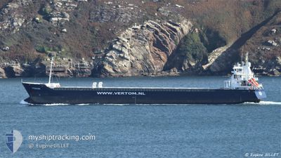
The current position of PENHAR is in English Channel with coordinates 50.56749° / 0.18826° as reported on 2024-10-21 07:54 by AIS to our vessel tracker app. The vessel's current speed is 9.1 Knots and is heading at the port of PARAMARIBO. The estimated time of arrival as calculated by MyShipTracking vessel tracking app is 2024-11-07 05:00 LT
The vessel PENHAR (IMO: 9534365, MMSI: 246666000) is a General Cargo that was built in 2010 ( 14 år gamle ). It's sailing under the flag of [NL] Netherlands.
In this page you can find informations about the vessels current position, last detected port calls, and current voyage information. If the vessels is not in coverage by AIS you will find the latest position.
The current position of PENHAR is detected by our AIS receivers and we are not responsible for the reliability of the data. The last position was recorded while the vessel was in Coverage by the Ais receivers of our vessel tracking app.
The current draught of PENHAR as reported by AIS is 5.9 meters
Weather
| Temperature | 14.4°C / 57.92°F |
|---|---|
| Wind Speed | 14 knots |
| Direction | 225° SW |
| Pressure | 1021.2 hPa |
| Humidity | 80.1 % |
| Cloud Coverage | 100 % |
Featured Company
Last Port Calls
| Port | Arrival | Departure | Time In Port |
|---|---|---|---|
| 2024-10-19 02:43 | 2024-10-20 13:34 | 1 d | |
| 2024-10-16 23:34 | 2024-10-18 22:39 | 1 d | |
| 2024-10-12 07:20 | 2024-10-15 21:00 | 3 d | |
| 2024-09-24 11:25 | 2024-10-07 04:23 | 12 d | |
| 2024-09-14 11:20 | 2024-09-17 19:20 | 3 d | |
| 2024-09-05 14:30 | 2024-09-06 18:17 | 1 d | |
| 2024-08-30 06:05 | 2024-08-30 20:32 | 14 h | |
| 2024-08-28 20:00 | 2024-08-30 03:50 | 1 d | |
| 2024-08-23 21:24 | 2024-08-25 23:58 | 2 d | |
| 2024-08-19 03:57 | 2024-08-20 07:26 | 1 d |
Most Visited Ports (Last year)
| Port | Arrivals | |
|---|---|---|
| 5 | ||
| 3 | ||
| 2 | ||
| 2 | ||
| 2 | ||
| 2 |
Last Trips
| Origin | Departure | Destination | Arrival | Distance | |
|---|---|---|---|---|---|
| 2024-10-19 00:39 | 2024-10-19 04:43 | 30.12 nm | |||
| 2024-10-15 22:00 | 2024-10-17 01:34 | 237.30 nm | |||
| 2024-10-07 06:23 | 2024-10-12 08:20 | 986.10 nm | |||
| 2024-09-17 21:20 | 2024-09-24 13:25 | 1102.93 nm | |||
| 2024-09-06 19:17 | 2024-09-14 13:20 | 637.55 nm | |||
| 2024-08-30 22:32 | 2024-09-05 15:30 | 632.04 nm | |||
| 2024-08-30 05:50 | 2024-08-30 08:05 | 16.99 nm | |||
| 2024-08-26 00:58 | 2024-08-28 22:00 | 218.88 nm | |||
| 2024-08-20 09:26 | 2024-08-23 22:24 | 583.59 nm | |||
| 2024-08-16 11:24 | 2024-08-19 05:57 | 212.32 nm |
Events
| Tid | Hændelsen | Detaljer | Position / Dest | Info |
|---|---|---|---|---|
| 2024-10-21 06:26 | Status er ændret | Under way using engine Default |
50.63254 / .55106
SRPBM
|
Fart: 9.9 kn Kurs: 234° |
| 2024-10-21 06:21 | Status er ændret | Default Under way using engine |
50.63832 / .56698
SRPBM
|
Fart: 9.9 kn Kurs: 235° |
| 2024-10-21 06:07 | Status er ændret | Under way using engine Default |
50.66080 / .61703
SRPBM
|
Fart: 9.6 kn Kurs: 234° |
| 2024-10-21 06:01 | Status er ændret | Default Under way using engine |
50.66995 / .63730
SRPBM
|
Fart: 9.6 kn Kurs: 234.6° |
| 2024-10-21 00:23 | Ændre havområde | United Kingdom part of the English Channel United Kingdom part of the North Sea |
51.07746 / 1.47236
English Channel
SRPBM
|
Fart: 6.1 kn Kurs: 232.7° |
| 2024-10-20 20:55 | Ændre havområde | United Kingdom part of the North Sea French part of the North Sea |
51.39291 / 2.06636
North Sea
SRPBM
|
Fart: 9.2 kn Kurs: 288.9° |
| 2024-10-20 19:44 | Fundet i havområde | French part of the North Sea |
51.34792 / 2.34297
North Sea
SRPBM
|
Fart: 9.3 kn Kurs: 251.8° |
| 2024-10-20 15:29 | Ændre havområde | Belgian part of the North Sea Dutch part of the North Sea |
51.40967 / 3.31296
North Sea
SRPBM
|
Fart: 8.2 kn Kurs: 276.6° |
| 2024-10-20 13:34 | Afsejlet fra sidste havn |
|
51.44688 / 3.67052
SRPBM
|
Fart: 8.3 kn Kurs: 228° |
| 2024-10-20 13:12 | START Sejllads |
51.45572 / 3.72261
[NL] VLISSINGEN
|
Fart: 4.1 kn Kurs: 233° |