
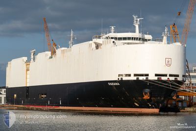
PARANA
Vehicles Carrier
Current Trip
| Trip Time | 1 day |
|---|---|
| Trip Distance | 612.73 nm |
| AVG Speed | 15.3 Knots |
| MAX Speed | 20.1 Knots |
| Dybgang | 8.2 m |
| AVG Wind | 12.2 knots |
| MAX Wind | 23 knots |
| MIN Temp | 6.7°C / 44.06°F |
| MAX Temp | 13.2°C / 55.76°F |
| Position Modtaget | 1 m siden |
Current Position
| Longitude | --- |
|---|---|
| Latitude | --- |
| Status | Under way using engine |
| Fart | |
| Kurs | 96° |
| Område | Bay of Biscay |
| Station | T-AIS |
| Position Modtaget | 1 m siden |
Info
Information
The current position of PARANA is in Bay of Biscay with coordinates 43.44250° / -3.82476° as reported on 2025-02-17 11:20 by AIS to our vessel tracker app. The vessel's current speed is 0 Knots and is currently inside the port of SANTANDER.
The vessel PARANA (IMO: 9427964, MMSI: 218562000) is a Vehicles Carrier that was built in 2012 ( 13 år gamle ). It's sailing under the flag of [DE] Germany.
In this page you can find informations about the vessels current position, last detected port calls, and current voyage information. If the vessels is not in coverage by AIS you will find the latest position.
The current position of PARANA is detected by our AIS receivers and we are not responsible for the reliability of the data. The last position was recorded while the vessel was in Coverage by the Ais receivers of our vessel tracking app.
The current draught of PARANA as reported by AIS is 8.2 meters
Weather
| Temperature | 13.6°C / 56.48°F |
|---|---|
| Wind Speed | 6 knots |
| Direction | 71° ENE |
| Pressure | 1016.4 hPa |
| Humidity | 80.5 % |
| Cloud Coverage | 47 % |
Featured Company
Last Port Calls
| Port | Arrival | Departure | Time In Port |
|---|---|---|---|
| 2025-02-17 10:44 | |||
| 2025-02-14 13:27 | 2025-02-15 21:53 | 1 d | |
| 2025-02-05 03:22 | 2025-02-06 18:24 | 1 d | |
| 2025-02-01 09:20 | 2025-02-02 14:31 | 1 d | |
| 2025-01-28 19:45 | 2025-01-30 02:10 | 1 d | |
| 2025-01-22 04:16 | 2025-01-24 03:23 | 1 d | |
| 2025-01-17 15:23 | 2025-01-18 15:38 | 1 d | |
| 2025-01-15 05:47 | 2025-01-15 19:15 | 13 h | |
| 2025-01-11 23:10 | 2025-01-13 02:28 | 1 d | |
| 2025-01-08 03:23 | 2025-01-09 16:24 | 1 d |
Last Trips
| Origin | Departure | Destination | Arrival | Distance | |
|---|---|---|---|---|---|
| 2025-02-15 21:53 | 2025-02-17 11:44 | 612.73 nm | |||
| 2025-02-06 18:24 | 2025-02-14 13:27 | 2121.20 nm | |||
| 2025-02-02 15:31 | 2025-02-05 03:22 | 670.28 nm | |||
| 2025-01-30 02:10 | 2025-02-01 10:20 | 626.77 nm | |||
| 2025-01-24 04:23 | 2025-01-28 19:45 | 1013.50 nm | |||
| 2025-01-18 15:38 | 2025-01-22 05:16 | 1361.13 nm | |||
| 2025-01-15 20:15 | 2025-01-17 15:23 | 637.63 nm | |||
| 2025-01-13 02:28 | 2025-01-15 06:47 | 627.36 nm | |||
| 2025-01-09 17:24 | 2025-01-11 23:10 | 811.51 nm | |||
| 2025-01-04 16:48 | 2025-01-08 04:23 | 904.49 nm |
Events
| Tid | Hændelsen | Detaljer | Position / Dest | Info |
|---|---|---|---|---|
| 2025-02-17 11:15 | STOP Sejllads |
43.44252 / -3.82467
[ES] SANTANDER
|
Fart: 0.2 kn Kurs: 98° |
|
| 2025-02-17 10:44 | Skibe i havn |
|
43.45799 / -3.79267
[ES] SANTANDER
|
Fart: 10.5 kn Kurs: 260° |
| 2025-02-17 09:14 | Status er ændret | Under way using engine Default |
43.71220 / -3.83924
IEDUB>ESSDR
|
Fart: 14.4 kn Kurs: 163° |
| 2025-02-17 09:11 | Status er ændret | Default Under way using engine |
43.72146 / -3.84323
IEDUB>ESSDR
|
Fart: 14.4 kn Kurs: 163.1° |
| 2025-02-17 09:11 | Ændre havområde | Spanish part of the Bay of Biscay French part of the Celtic Sea |
43.72262 / -3.84372
Bay of Biscay
IEDUB>ESSDR
|
Fart: 14.4 kn Kurs: 163.1° |
| 2025-02-17 09:10 | Status er ændret | Under way using engine Default |
43.72529 / -3.84485
IEDUB>ESSDR
|
Fart: 14.5 kn Kurs: 163° |
| 2025-02-17 08:55 | Indenfor Dækning |
43.72262 / -3.84372
Bay of Biscay
IEDUB>ESSDR
|
Fart: 14.4 kn Kurs: 163.1° |
|
| 2025-02-16 19:02 | Status er ændret | Default Under way using engine |
47.18333 / -5.36667
IEDUB>ESSDR
|
Fart: 17.3 kn Kurs: 162.2° |
| 2025-02-16 18:49 | Udenfor Dækning |
47.24088 / -5.39278
Celtic Sea
IEDUB>ESSDR
|
Fart: 17.3 kn Kurs: 162.2° |
|
| 2025-02-16 16:10 | Status er ændret | Under way using engine Default |
47.94219 / -5.71345
IEDUB>ESSDR
|
Fart: 15.7 kn Kurs: 162° |