
ONEGO RIO
General Cargo
Current Trip
| Time Travelled | 14 days |
|---|---|
| Remaining Time | --- |
| Distance Travelled | 699.45 nm |
| Remaining Distance | --- |
| AVG Speed | 9.7 Knots |
| MAX Speed | 15.7 Knots |
| AVG Wind | 11.9 knots |
| MAX Wind | 19.8 knots |
| MIN Temp | 7.5°C / 45.5°F |
| MAX Temp | 28.8°C / 83.84°F |
| Dybgang | 7.4 m |
| Position Modtaget | 3 h, 15 m siden |
Current Position
| Longitude | --- |
|---|---|
| Latitude | --- |
| Status | At anchor |
| Fart | 0.6 Knots |
| Kurs | 34° |
| Område | Gulf of Mexico |
| Station | T-AIS |
| Position Modtaget | 3 h, 15 m siden |
Info
Information
The current position of ONEGO RIO is in Gulf of Mexico with coordinates 22.42283° / -97.74115° as reported on 2024-10-21 23:04 by AIS to our vessel tracker app. The vessel's current speed is 0.6 Knots
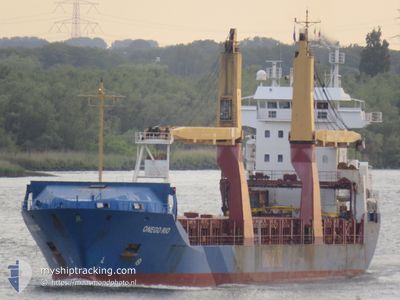
The vessel ONEGO RIO (IMO: 9258985, MMSI: 244150212) is a General Cargo that was built in 2003 ( 21 år gamle ). It's sailing under the flag of [NL] Netherlands.
In this page you can find informations about the vessels current position, last detected port calls, and current voyage information. If the vessels is not in coverage by AIS you will find the latest position.
The current position of ONEGO RIO is detected by our AIS receivers and we are not responsible for the reliability of the data. The last position was recorded while the vessel was in Coverage by the Ais receivers of our vessel tracking app.
The current draught of ONEGO RIO as reported by AIS is 7.4 meters
Weather
| Temperature | 26.8°C / 80.24°F |
|---|---|
| Wind Speed | 10 knots |
| Direction | 68° ENE |
| Pressure | 1016.9 hPa |
| Humidity | 77.1 % |
| Cloud Coverage | 100 % |
Featured Company
Last Port Calls
Most Visited Ports (Last year)
| Port | Arrivals | |
|---|---|---|
| 4 | ||
| 2 | ||
| 2 | ||
| 2 | ||
| 2 | ||
| 2 |
Last Trips
Events
| Tid | Hændelsen | Detaljer | Position / Dest | Info |
|---|---|---|---|---|
| 2024-10-21 23:07 | Status er ændret | Default At anchor |
22.42299 / -97.74113
MX ATM
|
Fart: 0.6 kn Kurs: 34° |
| 2024-10-21 23:04 | Status er ændret | At anchor Default |
22.42283 / -97.74115
MX ATM
|
Fart: 1.1 kn Kurs: 29° |
| 2024-10-21 23:04 | Indenfor Dækning |
22.42283 / -97.74115
Gulf of Mexico
|
Fart: 0.6 kn Kurs: 232.4° |
|
| 2024-10-21 23:04 | Udenfor Dækning |
22.42283 / -97.74115
Gulf of Mexico
|
Fart: 0.6 kn Kurs: 232.4° |
|
| 2024-10-21 11:55 | Status er ændret | Default At anchor |
22.42324 / -97.74162
MX ATM
|
Fart: 0.5 kn Kurs: 45° |
| 2024-10-21 11:43 | Udenfor Dækning |
22.42312 / -97.74153
Gulf of Mexico
|
Fart: 0.5 kn Kurs: 239.5° |
|
| 2024-10-21 11:40 | Indenfor Dækning |
22.42318 / -97.74156
Gulf of Mexico
|
Fart: 0.4 kn Kurs: 144.4° |
|
| 2024-10-21 08:58 | Status er ændret | Default At anchor |
22.42310 / -97.74145
MX ATM
|
Fart: 0.2 kn Kurs: 51° |
| 2024-10-21 08:46 | Udenfor Dækning |
22.42312 / -97.74146
Gulf of Mexico
|
Fart: 0.2 kn Kurs: 236.7° |
|
| 2024-10-21 08:43 | Status er ændret | At anchor Default |
22.42314 / -97.74144
MX ATM
|
Fart: 0.6 kn Kurs: 49° |