
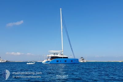
OHANA
Sailing
Current Trip
| Trip Time | 1 h, 44 mins |
|---|---|
| Trip Distance | 10.02 nm |
| AVG Speed | 8 Knots |
| MAX Speed | 8.8 Knots |
| Dybgang | --- |
| AVG Wind | 8.7 knots |
| MAX Wind | 9.8 knots |
| MIN Temp | 28.5°C / 83.3°F |
| MAX Temp | 28.7°C / 83.66°F |
| Position Modtaget | 3 m siden |
Current Position
| Longitude | -64.93032° |
|---|---|
| Latitude | 18.33359° |
| Status | Default |
| Fart | 0.1 Knots |
| Kurs | --- |
| Område | Caribbean Sea |
| Station | T-AIS |
| Position Modtaget | 3 m siden |
Info
Information
The current position of OHANA is in Caribbean Sea with coordinates 18.33359° / -64.93032° as reported on 2024-05-20 23:14 by AIS to our vessel tracker app. The vessel's current speed is 0.1 Knots and is currently inside the port of ST THOMAS.
The vessel OHANA (MMSI: 338445741) is a Sailing It's sailing under the flag of [US] USA.
In this page you can find informations about the vessels current position, last detected port calls, and current voyage information. If the vessels is not in coverage by AIS you will find the latest position.
The current position of OHANA is detected by our AIS receivers and we are not responsible for the reliability of the data. The last position was recorded while the vessel was in Coverage by the Ais receivers of our vessel tracking app.
Weather
| Temperature | 28.9°C / 84.02°F |
|---|---|
| Wind Speed | 13 knots |
| Direction | 115° ESE |
| Pressure | 1012.7 hPa |
| Humidity | 76.6 % |
| Cloud Coverage | 66 % |
Featured Company
Last Port Calls
| Port | Arrival | Departure | Time In Port |
|---|---|---|---|
| 2024-05-20 00:18 | |||
| 2024-05-19 19:11 | 2024-05-19 22:34 | 3 h | |
| 2024-05-17 13:17 | 2024-05-17 21:23 | 8 h | |
| 2024-05-14 20:19 | 2024-05-14 21:21 | 1 h | |
| 2024-05-12 12:15 | 2024-05-12 14:46 | 2 h | |
| 2024-05-10 20:19 | 2024-05-11 15:00 | 18 h | |
| 2024-04-27 20:35 | 2024-04-29 20:23 | 1 d | |
| 2024-04-26 16:08 | 2024-04-26 19:02 | 2 h | |
| 2024-04-25 17:37 | 2024-04-25 19:06 | 1 h | |
| 2024-04-24 19:47 | 2024-04-24 21:40 | 1 h |
Last Trips
| Origin | Departure | Destination | Arrival | Distance | |
|---|---|---|---|---|---|
| 2024-05-19 18:34 | 2024-05-19 20:18 | 10.02 nm | |||
| 2024-05-17 17:23 | 2024-05-19 15:11 | 13.53 nm | |||
| 2024-05-14 17:21 | 2024-05-17 09:17 | 40.04 nm | |||
| 2024-05-12 10:46 | 2024-05-14 16:19 | 42.02 nm | |||
| 2024-05-11 11:00 | 2024-05-12 08:15 | 27.68 nm | |||
| 2024-04-29 16:23 | 2024-05-10 16:19 | 120.61 nm | |||
| 2024-04-26 15:02 | 2024-04-27 16:35 | 22.31 nm | |||
| 2024-04-25 15:06 | 2024-04-26 12:08 | 4.51 nm | |||
| 2024-04-24 17:40 | 2024-04-25 13:37 | 4.27 nm | |||
| 2024-04-23 14:39 | 2024-04-24 15:47 | 13.46 nm |
Events
| Tid | Hændelsen | Detaljer | Position / Dest | Info |
|---|---|---|---|---|
| 2024-05-20 00:29 | STOP Sejllads |
18.33319 / -64.93023
[VI] ST THOMAS
|
Fart: 0.1 kn Kurs: 511° |
|
| 2024-05-20 00:18 | Skibe i havn |
|
18.32188 / -64.92662
[VI] ST THOMAS
|
Fart: 7.6 kn Kurs: 333° |
| 2024-05-19 23:07 | Fundet i havområde | Puerto Rican part of the Caribbean Sea |
18.35607 / -64.78442
Caribbean Sea
|
Fart: 8.4 kn Kurs: 248.3° |
| 2024-05-19 23:07 | START Sejllads | 1.63 nm, North East of CRUZ BAY |
18.35607 / -64.78442
|
Fart: 8.4 kn Kurs: 248.3° |
| 2024-05-19 22:34 | Afsejlet fra sidste havn |
|
18.35607 / -64.78442
|
Fart: 4.6 kn Kurs: 273.8° |
| 2024-05-19 20:50 | Indenfor Dækning |
18.38434 / -64.70788
Caribbean Sea
[VG] SOPERS HOLE
|
Fart: 0.1 kn Kurs: 511° |
|
| 2024-05-19 19:11 | Udenfor Dækning |
18.38453 / -64.70750
Caribbean Sea
[VG] SOPERS HOLE
|
Fart: 0.5 kn Kurs: 175.7° |
|
| 2024-05-19 19:11 | Fundet i havområde | British Virgin Islands part of the Caribbean Sea |
18.38453 / -64.70750
Caribbean Sea
|
Fart: 0.5 kn Kurs: 175.7° |
| 2024-05-19 19:11 | Skibe i havn |
|
18.38453 / -64.70750
[VG] SOPERS HOLE
|
Fart: 9.2 kn Kurs: 303.5° |
| 2024-05-19 18:34 | Fundet i havområde | Puerto Rican part of the Caribbean Sea |
18.33336 / -64.64390
Caribbean Sea
|
Fart: 8.8 kn Kurs: 324.5° |