
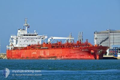
NCC SAMA
Oil/Chemical Tanker
Current Trip
| Time Travelled | 40 days |
|---|---|
| Remaining Time | --- |
| Distance Travelled | 1007.81 nm |
| Remaining Distance | --- |
| AVG Speed | 10.5 Knots |
| MAX Speed | 14.8 Knots |
| AVG Wind | 8.3 knots |
| MAX Wind | 22.5 knots |
| MIN Temp | 11.8°C / 53.24°F |
| MAX Temp | 25.6°C / 78.08°F |
| Dybgang | 7.4 m |
| Position Modtaget | 6 d siden |
Current Position
| Longitude | --- |
|---|---|
| Latitude | --- |
| Status | Under way using engine |
| Fart | 8.6 Knots |
| Kurs | 172.3° |
| Område | Gulf of Suez |
| Station | T-AIS |
| Position Modtaget | 6 d siden |
Info
Information
The current position of NCC SAMA is in Gulf of Suez with coordinates 29.86939° / 32.55143° as reported on 2025-12-28 09:14 by AIS to our vessel tracker app. The vessel's current speed is 8.6 Knots
The vessel NCC SAMA (IMO: 9480150, MMSI: 403529001) is a Oil/Chemical Tanker that was built in 2012 ( 14 år gamle ). It's sailing under the flag of [SA] Saudi Arabia.
In this page you can find informations about the vessels current position, last detected port calls, and current voyage information. If the vessels is not in coverage by AIS you will find the latest position.
The current position of NCC SAMA is detected by our AIS receivers and we are not responsible for the reliability of the data. The last position was recorded while the vessel was in Coverage by the Ais receivers of our vessel tracking app.
The current draught of NCC SAMA as reported by AIS is 7.4 meters
Weather
| Temperature | 25.6°C / 78.08°F |
|---|---|
| Wind Speed | 5 knots |
| Direction | 280° W |
| Pressure | 1013.6 hPa |
| Humidity | 66.5 % |
| Cloud Coverage | --- |
Featured Company
Last Trips
| Origin | Departure | Destination | Arrival | Distance | |
|---|---|---|---|---|---|
| 2025-10-30 11:05 | 2025-11-22 15:08 | 2830.21 nm |
Events
| Tid | Hændelsen | Detaljer | Position / Dest | Info |
|---|---|---|---|---|
| 2025-12-31 14:54 | START Sejllads | 5.8 nm, South West of JEDDAH |
21.40427 / 39.06437
SAGIZ
|
Fart: 4.6 kn Kurs: 277° |
| 2025-12-30 14:34 | STOP Sejllads | 5.66 nm, South West of JEDDAH |
21.40331 / 39.06821
SAGIZ
|
Fart: 0.3 kn Kurs: 319° |
| 2025-12-28 09:21 | Status er ændret | Default Under way using engine |
29.84763 / 32.55445
SAGIZ
|
Fart: 8.6 kn Kurs: 172.3° |
| 2025-12-28 09:14 | Udenfor Dækning |
29.86939 / 32.55143
Gulf of Suez
SAGIZ
|
Fart: 8.6 kn Kurs: 172.3° |
|
| 2025-12-28 08:55 | Destination er ændret | SAGIZ EGSUZ |
29.90381 / 32.52128
SAGIZ
|
Fart: 11.2 kn Kurs: 117.7° |
| 2025-12-28 08:55 | ETA er ændret | 2026/01/01 09:00 2026/11/25 19:00 |
29.90381 / 32.52128
SAGIZ
|
Fart: 11.2 kn Kurs: 117.7° |
| 2025-12-28 08:47 | START Sejllads | 2.49 nm, North East of AL ADABIYAH |
29.91618 / 32.50892
EGSUZ
|
Fart: 3.1 kn Kurs: 176° |
| 2025-12-28 08:41 | Status er ændret | Under way using engine Moored |
29.91756 / 32.50990
EGSUZ
|
Fart: 0.4 kn Kurs: 184° |
| 2025-12-28 03:31 | Status er ændret | Moored Default |
29.91733 / 32.51067
EGSUZ
|
Fart: Kurs: 172° |
| 2025-12-28 03:28 | Status er ændret | Default Moored |
29.91733 / 32.51067
EGSUZ
|
Fart: Kurs: 172° |