

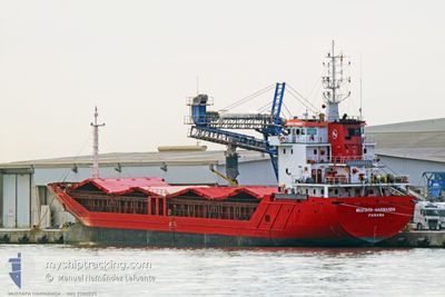
MUSTAFA HARMANDA
General Cargo

Current Trip
| Time Travelled | 3 days |
|---|---|
| Remaining Time | 1 day |
| Distance Travelled | 432.87 nm |
| Remaining Distance | 447.58 nm |
| AVG Speed | 7.3 Knots |
| MAX Speed | 9.1 Knots |
| AVG Wind | 16.1 knots |
| MAX Wind | 26.2 knots |
| MIN Temp | 3.3°C / 37.94°F |
| MAX Temp | 13.5°C / 56.3°F |
| Dybgang | 5.4 m |
| Position Modtaget | 1 d siden |
Current Position
| Longitude | --- |
|---|---|
| Latitude | --- |
| Status | Under way using engine |
| Fart | 8.5 Knots |
| Kurs | 130.6° |
| Område | Adriatic Sea |
| Station | T-AIS |
| Position Modtaget | 1 d siden |
Information
The current position of MUSTAFA HARMANDA is in Adriatic Sea with coordinates 41.82368° / 16.78328° as reported on 2025-02-16 19:14 by AIS to our vessel tracker app. The vessel's current speed is 8.5 Knots and is heading at the port of ELEFSIS. The estimated time of arrival as calculated by MyShipTracking vessel tracking app is 2025-02-19 19:09 LT
The vessel MUSTAFA HARMANDA (IMO: 9280225, MMSI: 371020000) is a General Cargo that was built in 2003 ( 22 år gamle ). It's sailing under the flag of [PA] Panama.
In this page you can find informations about the vessels current position, last detected port calls, and current voyage information. If the vessels is not in coverage by AIS you will find the latest position.
The current position of MUSTAFA HARMANDA is detected by our AIS receivers and we are not responsible for the reliability of the data. The last position was recorded while the vessel was in Coverage by the Ais receivers of our vessel tracking app.
The current draught of MUSTAFA HARMANDA as reported by AIS is 5.4 meters
Weather
| Temperature | 13.9°C / 57.02°F |
|---|---|
| Wind Speed | 17 knots |
| Direction | 346° NNW |
| Pressure | 1014.6 hPa |
| Humidity | 73.3 % |
| Cloud Coverage | 100 % |


Featured Company
Last Port Calls
| Port | Arrival | Departure | Time In Port |
|---|---|---|---|
| 2025-02-11 06:37 | 2025-02-14 07:27 | 3 d | |
| 2025-02-07 06:24 | 2025-02-10 14:26 | 3 d | |
| 2025-01-27 13:33 | 2025-01-29 02:21 | 1 d | |
| 2025-01-21 14:51 | 2025-01-24 18:57 | 3 d | |
| 2024-12-31 12:04 | 2025-01-15 15:26 | 15 d | |
| 2024-12-26 08:52 | 2024-12-28 06:24 | 1 d | |
| 2024-12-17 15:56 | 2024-12-19 10:22 | 1 d | |
| 2024-12-11 08:12 | 2024-12-16 15:52 | 5 d |
Most Visited Ports (Last year)
| Port | Arrivals | |
|---|---|---|
| 6 | ||
| 5 | ||
| 4 | ||
| 4 | ||
| 3 | ||
| 2 |
Last Trips
| Origin | Departure | Destination | Arrival | Distance | |
|---|---|---|---|---|---|
| 2025-02-10 15:26 | 2025-02-11 07:37 | 102.05 nm | |||
| 2025-01-29 04:21 | 2025-02-07 07:24 | 1378.14 nm | |||
| 2025-01-24 20:57 | 2025-01-27 15:33 | 547.19 nm | |||
| 2025-01-15 17:26 | 2025-01-21 16:51 | 612.70 nm | |||
| 2024-12-28 09:24 | 2024-12-31 14:04 | 259.63 nm | |||
| 2024-12-19 13:22 | 2024-12-26 11:52 | 590.77 nm | |||
| 2024-12-16 17:52 | 2024-12-17 18:56 | 199.19 nm | |||
| 2024-11-27 09:08 | 2024-12-11 10:12 | 728.72 nm |
Events
| Tid | Hændelsen | Detaljer | Position / Dest | Info |
|---|---|---|---|---|
| 2025-02-16 19:14 | Udenfor Dækning |
41.82368 / 16.78328
Adriatic Sea
GRELE
|
Fart: 8.5 kn Kurs: 130.6° |
|
| 2025-02-16 15:13 | Ændre havområde | Italian part of the Adriatic Sea Croatian part of the Adriatic Sea |
42.18716 / 16.20574
Adriatic Sea
GRELE
|
Fart: 8 kn Kurs: 129.4° |
| 2025-02-16 13:25 | Fundet i havområde | Croatian part of the Adriatic Sea |
42.34971 / 15.97858
Adriatic Sea
GRELE
|
Fart: 7.3 kn Kurs: 133° |
| 2025-02-16 12:23 | Ændre havområde | Italian part of the Adriatic Sea Croatian part of the Adriatic Sea |
42.45790 / 15.86495
Adriatic Sea
GRELE
|
Fart: 8.1 kn Kurs: 155.8° |
| 2025-02-16 10:38 | ETA er ændret | 2025/02/19 18:00 2025/02/19 06:00 |
42.65398 / 15.70932
GRELE
|
Fart: 7.6 kn Kurs: 158.5° |
| 2025-02-16 10:19 | Status er ændret | Under way using engine Default |
42.68900 / 15.68629
GRELE
|
Fart: 7 kn Kurs: 152° |
| 2025-02-16 10:19 | Indenfor Dækning |
42.68900 / 15.68629
Adriatic Sea
GRELE
|
Fart: 6.9 kn Kurs: 152.4° |
|
| 2025-02-15 18:43 | Status er ændret | Default Under way using engine |
44.48760 / 14.28163
GRELE
|
Fart: 8 kn Kurs: 125° |
| 2025-02-15 18:39 | Udenfor Dækning |
44.49356 / 14.26966
Adriatic Sea
GRELE
|
Fart: 8 kn Kurs: 125° |
|
| 2025-02-15 09:39 | Dybgangen er ændret | 5.4 5 |
45.51963 / 13.33356
GRELE
|
Fart: 7.6 kn Kurs: 161.2° |