
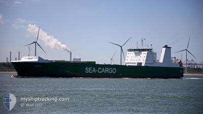
MISIDA
Ro-Ro Cargo
Current Trip
| Time Travelled | 9 h, 23 mins |
|---|---|
| Remaining Time | 16 h, 43 mins |
| Distance Travelled | 138.01 nm |
| Remaining Distance | 336.73 nm |
| AVG Speed | 13.3 Knots |
| MAX Speed | 16.3 Knots |
| AVG Wind | 11.6 knots |
| MAX Wind | 16.1 knots |
| MIN Temp | 7°C / 44.6°F |
| MAX Temp | 9.4°C / 48.92°F |
| Dybgang | 6.6 m |
| Position Modtaget | 5 h, 36 m siden |
Current Position
| Longitude | 0.63615° |
|---|---|
| Latitude | 54.07316° |
| Status | Under way using engine |
| Fart | 15.8 Knots |
| Kurs | 24° |
| Område | North Sea |
| Station | T-AIS |
| Position Modtaget | 5 h, 36 m siden |
Info
Information
The current position of MISIDA is in North Sea with coordinates 54.07316° / 0.63615° as reported on 2024-04-27 18:47 by AIS to our vessel tracker app. The vessel's current speed is 15.8 Knots and is heading at the port of TANANGER. The estimated time of arrival as calculated by MyShipTracking vessel tracking app is 2024-04-28 17:06 LT
The vessel MISIDA (IMO: 9348948, MMSI: 230995000) is a Ro-Ro Cargo that was built in 2007 ( 17 år gamle ). It's sailing under the flag of [FI] Finland.
In this page you can find informations about the vessels current position, last detected port calls, and current voyage information. If the vessels is not in coverage by AIS you will find the latest position.
The current position of MISIDA is detected by our AIS receivers and we are not responsible for the reliability of the data. The last position was recorded while the vessel was in Coverage by the Ais receivers of our vessel tracking app.
The current draught of MISIDA as reported by AIS is 6.6 meters
Weather
| Temperature | 7.3°C / 45.14°F |
|---|---|
| Wind Speed | 15 knots |
| Direction | 69° ENE |
| Pressure | 1007 hPa |
| Humidity | 89.4 % |
| Cloud Coverage | 100 % |
Featured Company
Last Port Calls
| Port | Arrival | Departure | Time In Port |
|---|---|---|---|
| 2024-04-27 07:13 | 2024-04-27 15:00 | 7 h | |
| 2024-04-26 04:41 | 2024-04-26 17:39 | 12 h | |
| 2024-04-24 16:59 | 2024-04-24 19:52 | 2 h | |
| 2024-04-24 12:29 | 2024-04-24 15:08 | 2 h | |
| 2024-04-22 23:33 | 2024-04-23 12:24 | 12 h | |
| 2024-04-22 01:06 | 2024-04-22 04:01 | 2 h | |
| 2024-04-21 18:29 | 2024-04-21 19:16 | 47 m | |
| 2024-04-21 13:38 | 2024-04-21 16:14 | 2 h | |
| 2024-04-19 05:41 | 2024-04-20 06:30 | 1 d | |
| 2024-04-15 17:05 | 2024-04-16 10:35 | 17 h |
Most Visited Ports (Last year)
| Port | Arrivals | |
|---|---|---|
| 85 | ||
| 53 | ||
| 53 | ||
| 47 | ||
| 28 | ||
| 10 |
Last Trips
| Origin | Departure | Destination | Arrival | Distance | |
|---|---|---|---|---|---|
| 2024-04-26 19:39 | 2024-04-27 08:13 | 201.85 nm | |||
| 2024-04-24 21:52 | 2024-04-26 06:41 | 454.20 nm | |||
| 2024-04-24 17:08 | 2024-04-24 18:59 | 26.15 nm | |||
| 2024-04-23 14:24 | 2024-04-24 14:29 | 352.02 nm | |||
| 2024-04-22 06:01 | 2024-04-23 01:33 | 269.86 nm | |||
| 2024-04-21 21:16 | 2024-04-22 03:06 | 76.18 nm | |||
| 2024-04-21 18:14 | 2024-04-21 20:29 | 27.71 nm | |||
| 2024-04-20 08:30 | 2024-04-21 15:38 | 447.70 nm | |||
| 2024-04-16 12:35 | 2024-04-19 07:41 | 808.00 nm | |||
| 2024-04-14 22:45 | 2024-04-15 19:05 | 279.76 nm |
Events
| Tid | Hændelsen | Detaljer | Position / Dest | Info |
|---|---|---|---|---|
| 2024-04-27 18:50 | Status er ændret | Default Under way using engine |
54.08667 / .64500
NO RISAVIKA
|
Fart: 15.8 kn Kurs: 24° |
| 2024-04-27 18:47 | Udenfor Dækning |
54.07316 / .63615
North Sea
NO RISAVIKA
|
Fart: 15.8 kn Kurs: 24° |
|
| 2024-04-27 18:43 | Status er ændret | Under way using engine Default |
54.06031 / .62644
NO RISAVIKA
|
Fart: 15.8 kn Kurs: 24° |
| 2024-04-27 18:39 | Status er ændret | Default Under way using engine |
54.04229 / .61282
NO RISAVIKA
|
Fart: 15.7 kn Kurs: 23.6° |
| 2024-04-27 18:11 | Status er ændret | Under way using engine Default |
53.92792 / .54087
NO RISAVIKA
|
Fart: 15.4 kn Kurs: 14° |
| 2024-04-27 18:08 | Indenfor Dækning |
53.94113 / .54657
North Sea
NO RISAVIKA
|
Fart: 15.4 kn Kurs: 14° |
|
| 2024-04-27 16:48 | Status er ændret | Default Under way using engine |
53.60931 / .34057
NO RISAVIKA
|
Fart: 14.8 kn Kurs: 41.7° |
| 2024-04-27 16:43 | Udenfor Dækning |
53.59190 / .31579
North Sea
NO RISAVIKA
|
Fart: 14.8 kn Kurs: 41.7° |
|
| 2024-04-27 15:00 | Afsejlet fra sidste havn |
|
53.63508 / -.17509
NO RISAVIKA
|
Fart: 6.4 kn Kurs: 93° |
| 2024-04-27 14:57 | START Sejllads |
53.63360 / -.18227
[GB] IMMINGHAM
|
Fart: 7.5 kn Kurs: 68° |