
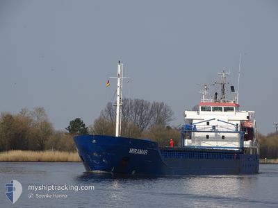
MIRAMAR
General Cargo
Current Trip
DERAN
| Time Travelled | 3 days |
|---|---|
| Remaining Time | --- |
| Distance Travelled | 499.48 nm |
| Remaining Distance | --- |
| AVG Speed | 11.4 Knots |
| MAX Speed | 12.6 Knots |
| AVG Wind | 6.7 knots |
| MAX Wind | 17 knots |
| MIN Temp | 0.2°C / 32.36°F |
| MAX Temp | 7.1°C / 44.78°F |
| Dybgang | 6.1 m |
| Position Modtaget | 1 m siden |
Current Position
| Longitude | 19.32769° |
|---|---|
| Latitude | 58.96864° |
| Status | Under way using engine |
| Fart | 10.7 Knots |
| Kurs | 209.7° |
| Område | Baltic Sea |
| Station | T-AIS |
| Position Modtaget | 1 m siden |
Info
Information
The current position of MIRAMAR is in Baltic Sea with coordinates 58.96864° / 19.32769° as reported on 2024-05-03 06:31 by AIS to our vessel tracker app. The vessel's current speed is 10.7 Knots
The vessel MIRAMAR (IMO: 9552044, MMSI: 212584000) is a General Cargo that was built in 2011 ( 13 år gamle ). It's sailing under the flag of [CY] Cyprus.
In this page you can find informations about the vessels current position, last detected port calls, and current voyage information. If the vessels is not in coverage by AIS you will find the latest position.
The current position of MIRAMAR is detected by our AIS receivers and we are not responsible for the reliability of the data. The last position was recorded while the vessel was in Coverage by the Ais receivers of our vessel tracking app.
The current draught of MIRAMAR as reported by AIS is 6.1 meters
Weather
| Temperature | 5.5°C / 41.9°F |
|---|---|
| Wind Speed | 10 knots |
| Direction | 90° E |
| Pressure | 1020.3 hPa |
| Humidity | 83.4 % |
| Cloud Coverage | 26 % |
Featured Company
Last Port Calls
| Port | Arrival | Departure | Time In Port |
|---|---|---|---|
| 2024-04-27 19:28 | 2024-04-29 18:38 | 1 d | |
| 2024-04-26 09:36 | 2024-04-27 11:52 | 1 d | |
| 2024-04-24 07:00 | 2024-04-26 01:08 | 1 d | |
| 2024-04-20 01:30 | 2024-04-20 01:33 | 2 m | |
| 2024-04-18 07:32 | 2024-04-18 09:03 | 1 h | |
| 2024-04-16 12:58 | 2024-04-18 06:03 | 1 d | |
| 2024-04-15 18:36 | 2024-04-16 12:21 | 17 h | |
| 2024-04-15 18:01 | 2024-04-15 18:18 | 16 m | |
| 2024-03-28 08:04 | 2024-04-09 19:24 | 12 d | |
| 2024-03-21 10:57 | 2024-03-21 11:00 | 3 m |
Last Trips
| Origin | Departure | Destination | Arrival | Distance | |
|---|---|---|---|---|---|
| 2024-04-27 13:52 | 2024-04-27 22:28 | 80.75 nm | |||
| 2024-04-26 04:08 | 2024-04-26 11:36 | 80.31 nm | |||
| 2024-04-20 03:33 | 2024-04-24 10:00 | 966.40 nm | |||
| 2024-04-18 11:03 | 2024-04-20 03:30 | 368.67 nm | |||
| 2024-04-18 08:03 | 2024-04-18 09:32 | 8.10 nm | |||
| 2024-04-16 14:21 | 2024-04-16 14:58 | 5.18 nm | |||
| 2024-04-15 20:18 | 2024-04-15 20:36 | 0.09 nm | |||
| 2024-04-09 22:24 | 2024-04-15 20:01 | 1325.26 nm | |||
| 2024-03-21 12:00 | 2024-03-28 10:04 | 991.00 nm | |||
| 2024-03-19 21:12 | 2024-03-21 11:57 | 367.69 nm |
Events
| Tid | Hændelsen | Detaljer | Position / Dest | Info |
|---|---|---|---|---|
| 2024-05-03 05:54 | Status er ændret | Under way using engine Default |
59.06757 / 19.43961
DERAN
|
Fart: 11 kn Kurs: 210° |
| 2024-05-03 05:48 | Status er ændret | Default Under way using engine |
59.08166 / 19.45561
DERAN
|
Fart: 11.1 kn Kurs: 208.6° |
| 2024-05-03 05:41 | Status er ændret | Under way using engine Default |
59.10228 / 19.47768
DERAN
|
Fart: 11.1 kn Kurs: 207° |
| 2024-05-03 05:37 | Status er ændret | Default Under way using engine |
59.11311 / 19.48881
DERAN
|
Fart: 11 kn Kurs: 206.6° |
| 2024-05-03 05:23 | Status er ændret | Under way using engine Default |
59.14917 / 19.52385
DERAN
|
Fart: 10.8 kn Kurs: 208° |
| 2024-05-03 05:20 | Status er ændret | Default Under way using engine |
59.15766 / 19.53229
DERAN
|
Fart: 10.8 kn Kurs: 210.3° |
| 2024-05-03 03:57 | Status er ændret | Under way using engine Default |
59.37710 / 19.79504
DERAN
|
Fart: 11.1 kn Kurs: 210° |
| 2024-05-03 03:49 | Status er ændret | Default Under way using engine |
59.39957 / 19.82089
DERAN
|
Fart: 11 kn Kurs: 210.5° |
| 2024-05-03 03:44 | Status er ændret | Under way using engine Default |
59.41233 / 19.83538
DERAN
|
Fart: 11 kn Kurs: 211° |
| 2024-05-03 03:36 | Status er ændret | Default Under way using engine |
59.43202 / 19.85817
DERAN
|
Fart: 11.1 kn Kurs: 209.8° |