
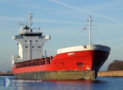
MERITA
General Cargo
Current Trip
| Trip Time | 2 days |
|---|---|
| Trip Distance | 598.35 nm |
| AVG Speed | 11.5 Knots |
| MAX Speed | 13.5 Knots |
| Dybgang | 4.5 m |
| AVG Wind | 10.7 knots |
| MAX Wind | 15 knots |
| MIN Temp | 5°C / 41°F |
| MAX Temp | 7.2°C / 44.96°F |
| Position Modtaget | 2 d siden |
Current Position
| Longitude | --- |
|---|---|
| Latitude | --- |
| Status | Under way using engine |
| Fart | 12.8 Knots |
| Kurs | 62.5° |
| Område | Kattegat |
| Station | T-AIS |
| Position Modtaget | 2 d siden |
Info
Information
The current position of MERITA is in Kattegat with coordinates 55.53684° / 15.05312° as reported on 2025-12-04 10:51 by AIS to our vessel tracker app. The vessel's current speed is 12.8 Knots and is currently inside the port of RIGA.
The vessel MERITA (IMO: 8422034, MMSI: 255805880) is a General Cargo that was built in 1985 ( 40 år gamle ). It's sailing under the flag of [PT] Portugal.
In this page you can find informations about the vessels current position, last detected port calls, and current voyage information. If the vessels is not in coverage by AIS you will find the latest position.
The current position of MERITA is detected by our AIS receivers and we are not responsible for the reliability of the data. The last position was recorded while the vessel was in Coverage by the Ais receivers of our vessel tracking app.
The current draught of MERITA as reported by AIS is 4.5 meters
Weather
| Temperature | 4.6°C / 40.28°F |
|---|---|
| Wind Speed | 12 knots |
| Direction | 166° SSE |
| Pressure | 1016.9 hPa |
| Humidity | 87.6 % |
| Cloud Coverage | 100 % |
Featured Company
Last Port Calls
| Port | Arrival | Departure | Time In Port |
|---|---|---|---|
| 2025-12-05 17:29 | |||
| 2025-12-02 06:19 | 2025-12-03 15:29 | 1 d | |
| 2025-11-28 19:37 | 2025-11-30 09:01 | 1 d | |
| 2025-11-27 07:21 | 2025-11-27 21:25 | 14 h | |
| 2025-11-24 09:51 | 2025-11-25 14:13 | 1 d | |
| 2025-11-22 00:12 | 2025-11-23 17:12 | 1 d | |
| 2025-11-19 09:04 | 2025-11-20 09:09 | 1 d | |
| 2025-11-16 15:20 | 2025-11-17 21:53 | 1 d | |
| 2025-11-14 09:08 | 2025-11-15 10:32 | 1 d | |
| 2025-11-11 19:03 | 2025-11-12 17:16 | 22 h |
Last Trips
| Origin | Departure | Destination | Arrival | Distance | |
|---|---|---|---|---|---|
| 2025-12-03 15:29 | 2025-12-05 17:29 | 598.35 nm | |||
| 2025-11-30 09:01 | 2025-12-02 06:19 | 507.12 nm | |||
| 2025-11-27 21:25 | 2025-11-28 19:37 | 227.54 nm | |||
| 2025-11-25 14:13 | 2025-11-27 07:21 | 442.28 nm | |||
| 2025-11-23 17:12 | 2025-11-24 09:51 | 193.25 nm | |||
| 2025-11-20 09:09 | 2025-11-22 00:12 | 451.43 nm | |||
| 2025-11-17 21:53 | 2025-11-19 09:04 | 346.85 nm | |||
| 2025-11-15 10:32 | 2025-11-16 15:20 | 351.85 nm | |||
| 2025-11-12 17:16 | 2025-11-14 09:08 | 181.18 nm | |||
| 2025-11-08 00:47 | 2025-11-11 19:03 | 712.74 nm |
Events
| Tid | Hændelsen | Detaljer | Position / Dest | Info |
|---|---|---|---|---|
| 2025-12-05 15:41 | STOP Sejllads |
56.98461 / 24.09341
[LV] RIGA
|
Fart: 0.2 kn Kurs: 186° |
|
| 2025-12-05 15:29 | Skibe i havn |
|
56.98671 / 24.09272
[LV] RIGA
|
Fart: 2.3 kn Kurs: 173° |
| 2025-12-04 10:53 | Status er ændret | Default Under way using engine |
55.53995 / 15.06452
LVRIX
|
Fart: 12.8 kn Kurs: 62.5° |
| 2025-12-04 10:51 | Udenfor Dækning |
55.53684 / 15.05312
Kattegat
LVRIX
|
Fart: 12.8 kn Kurs: 62.5° |
|
| 2025-12-04 10:44 | Status er ændret | Under way using engine Default |
55.52587 / 15.01337
LVRIX
|
Fart: 12.7 kn Kurs: 64° |
| 2025-12-04 10:41 | Status er ændret | Default Under way using engine |
55.52117 / 14.99631
LVRIX
|
Fart: 13 kn Kurs: 64.5° |
| 2025-12-04 10:22 | Status er ændret | Under way using engine Default |
55.49164 / 14.89064
LVRIX
|
Fart: 12.8 kn Kurs: 62° |
| 2025-12-04 10:21 | Status er ændret | Default Under way using engine |
55.48946 / 14.88305
LVRIX
|
Fart: 12.9 kn Kurs: 61° |
| 2025-12-04 10:09 | Status er ændret | Under way using engine Default |
55.46962 / 14.81574
LVRIX
|
Fart: 12.9 kn Kurs: 63° |
| 2025-12-04 10:01 | Status er ændret | Default Under way using engine |
55.45647 / 14.77121
LVRIX
|
Fart: 12.8 kn Kurs: 63° |