
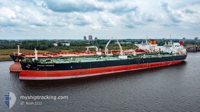
MARAN HERMES
Tanker
Current Trip
| Time Travelled | 8 days |
|---|---|
| Remaining Time | 7 days |
| Distance Travelled | 2446.79 nm |
| Remaining Distance | 2204.63 nm |
| AVG Speed | 11.5 Knots |
| MAX Speed | 14.8 Knots |
| AVG Wind | 10.3 knots |
| MAX Wind | 23.6 knots |
| MIN Temp | 26.1°C / 78.98°F |
| MAX Temp | 28.8°C / 83.84°F |
| Dybgang | 14.9 m |
| Position Modtaget | 6 d siden |
Current Position
| Longitude | --- |
|---|---|
| Latitude | --- |
| Status | Under way using engine |
| Fart | 13.2 Knots |
| Kurs | 129.1° |
| Område | Gulf of Oman |
| Station | T-AIS |
| Position Modtaget | 6 d siden |
Info
Information
The current position of MARAN HERMES is in Gulf of Oman with coordinates 24.97205° / 57.22725° as reported on 2024-11-15 22:34 by AIS to our vessel tracker app. The vessel's current speed is 13.2 Knots and is heading at the port of DURBAN. The estimated time of arrival as calculated by MyShipTracking vessel tracking app is 2024-11-29 13:10 LT
The vessel MARAN HERMES (IMO: 9761346, MMSI: 241486000) is a Tanker It's sailing under the flag of [GR] Greece.
In this page you can find informations about the vessels current position, last detected port calls, and current voyage information. If the vessels is not in coverage by AIS you will find the latest position.
The current position of MARAN HERMES is detected by our AIS receivers and we are not responsible for the reliability of the data. The last position was recorded while the vessel was in Coverage by the Ais receivers of our vessel tracking app.
The current draught of MARAN HERMES as reported by AIS is 14.9 meters
Weather
| Temperature | 27.6°C / 81.68°F |
|---|---|
| Wind Speed | 6 knots |
| Direction | 243° WSW |
| Pressure | 1009.4 hPa |
| Humidity | 73.7 % |
| Cloud Coverage | 66 % |
Featured Company
Last Port Calls
| Port | Arrival | Departure | Time In Port |
|---|---|---|---|
| 2024-11-12 18:49 | 2024-11-14 02:16 | 1 d | |
| 2024-10-15 03:15 | 2024-10-16 21:13 | 1 d | |
| 2024-10-11 09:41 | 2024-10-13 07:00 | 1 d |
Most Visited Ports (Last year)
| Port | Arrivals | |
|---|---|---|
| 4 | ||
| 2 | ||
| 1 | ||
| 1 | ||
| 1 | ||
| 1 |
Last Trips
| Origin | Departure | Destination | Arrival | Distance | |
|---|---|---|---|---|---|
| 2024-10-16 21:13 | 2024-11-12 18:49 | 4435.76 nm | |||
| 2024-10-13 07:00 | 2024-10-15 03:15 | 42.87 nm | |||
| 2024-08-23 05:49 | 2024-10-11 09:41 | 9426.48 nm |
Events
| Tid | Hændelsen | Detaljer | Position / Dest | Info |
|---|---|---|---|---|
| 2024-11-15 22:35 | Status er ændret | Default Under way using engine |
24.96907 / 57.23125
ZA DUR
|
Fart: 13.2 kn Kurs: 129.1° |
| 2024-11-15 22:34 | Udenfor Dækning |
24.97205 / 57.22725
Gulf of Oman
ZA DUR
|
Fart: 13.2 kn Kurs: 129.1° |
|
| 2024-11-15 21:49 | Ændre havområde | Omani part of the Gulf of Oman United Arab Emirates part of the Gulf of Oman |
25.08003 / 57.09296
Gulf of Oman
ZA DUR
|
Fart: 13.1 kn Kurs: 134.3° |
| 2024-11-15 21:48 | Status er ændret | Under way using engine Default |
25.08475 / 57.08774
ZA DUR
|
Fart: 13 kn Kurs: 138° |
| 2024-11-15 21:41 | Status er ændret | Default Under way using engine |
25.10185 / 57.06995
ZA DUR
|
Fart: 13 kn Kurs: 138.6° |
| 2024-11-15 18:49 | Ændre havområde | United Arab Emirates part of the Gulf of Oman Omani part of the Gulf of Oman |
25.66394 / 56.79439
Gulf of Oman
ZA DUR
|
Fart: 12.9 kn Kurs: 158.7° |
| 2024-11-15 17:37 | Ændre havområde | Omani part of the Gulf of Oman United Arab Emirates part of the Persian Gulf |
25.91486 / 56.72786
Gulf of Oman
ZA DUR
|
Fart: 12.6 kn Kurs: 171.6° |
| 2024-11-15 17:36 | Status er ændret | Under way using engine Default |
25.91891 / 56.72730
ZA DUR
|
Fart: 12.6 kn Kurs: 175° |
| 2024-11-15 17:36 | Indenfor Dækning |
25.91486 / 56.72786
Gulf of Oman
ZA DUR
|
Fart: 12.6 kn Kurs: 171.6° |
|
| 2024-11-15 07:24 | Udenfor Dækning |
26.06731 / 55.80102
Persian Gulf
ZA DUR
|
Fart: 3 kn Kurs: 78.5° |