
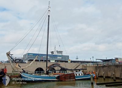
MALLEJAN
Sailing
Current Trip
NL HAR
| Time Travelled | 18 h, 40 mins |
|---|---|
| Remaining Time | --- |
| Distance Travelled | 0.23 nm |
| Remaining Distance | --- |
| AVG Speed | --- |
| MAX Speed | --- |
| AVG Wind | 6.8 knots |
| MAX Wind | 6.8 knots |
| MIN Temp | 11.9°C / 53.42°F |
| MAX Temp | 11.9°C / 53.42°F |
| Dybgang | 0.8 m |
| Position Modtaget | 18 h, 38 m siden |
Current Position
| Longitude | 5.39628° |
|---|---|
| Latitude | 53.17186° |
| Status | Under way sailing |
| Fart | 6.3 Knots |
| Kurs | 217.3° |
| Område | North Sea |
| Station | T-AIS |
| Position Modtaget | 18 h, 38 m siden |
Info
Information
The current position of MALLEJAN is in North Sea with coordinates 53.17186° / 5.39628° as reported on 2024-05-03 06:38 by AIS to our vessel tracker app. The vessel's current speed is 6.3 Knots
The vessel MALLEJAN (MMSI: 244000662) is a Sailing It's sailing under the flag of [NL] Netherlands.
In this page you can find informations about the vessels current position, last detected port calls, and current voyage information. If the vessels is not in coverage by AIS you will find the latest position.
The current position of MALLEJAN is detected by our AIS receivers and we are not responsible for the reliability of the data. The last position was recorded while the vessel was in Coverage by the Ais receivers of our vessel tracking app.
The current draught of MALLEJAN as reported by AIS is 0.8 meters
Weather
| Temperature | 11.9°C / 53.42°F |
|---|---|
| Wind Speed | 6 knots |
| Direction | 196° SSW |
| Pressure | 1002.6 hPa |
| Humidity | 95.4 % |
| Cloud Coverage | 46 % |
Featured Company
Last Port Calls
| Port | Arrival | Departure | Time In Port |
|---|---|---|---|
| 2024-04-21 10:30 | 2024-05-03 06:36 | 11 d | |
| 2024-04-01 11:31 | 2024-04-20 14:24 | 19 d | |
| 2024-03-31 09:21 | 2024-04-01 07:09 | 21 h | |
| 2024-03-25 14:41 | 2024-03-30 09:49 | 4 d | |
| 2024-03-25 07:51 | 2024-03-25 12:52 | 5 h | |
| 2024-03-23 13:27 | 2024-03-25 05:12 | 1 d | |
| 2024-03-02 16:42 | 2024-03-23 09:50 | 20 d | |
| 2024-03-02 12:31 |
Most Visited Ports (Last year)
| Port | Arrivals | |
|---|---|---|
| 5 | ||
| 2 |
Last Trips
| Origin | Departure | Destination | Arrival | Distance | |
|---|---|---|---|---|---|
| 2024-04-20 16:24 | 2024-04-21 12:30 | 1.56 nm | |||
| 2024-04-01 09:09 | 2024-04-01 13:31 | 18.18 nm | |||
| 2024-03-30 10:49 | 2024-03-31 11:21 | 21.95 nm | |||
| 2024-03-25 13:52 | 2024-03-25 15:41 | 3.42 nm | |||
| 2024-03-25 06:12 | 2024-03-25 08:51 | 16.05 nm | |||
| 2024-03-23 10:50 | 2024-03-23 14:27 | 14.58 nm | |||
| 2024-03-02 13:31 | 2024-03-02 17:42 | 16.51 nm |
Events
| Tid | Hændelsen | Detaljer | Position / Dest | Info |
|---|---|---|---|---|
| 2024-05-03 06:38 | Udenfor Dækning |
53.17186 / 5.39628
North Sea
|
Fart: 6.3 kn Kurs: 217.3° |
|
| 2024-05-03 06:36 | Afsejlet fra sidste havn |
|
53.17485 / 5.40005
NL HAR
|
Fart: 7.4 kn Kurs: 212.8° |
| 2024-05-03 06:32 | START Sejllads |
53.17492 / 5.40808
[NL] HARLINGEN
|
Fart: 5.9 kn Kurs: 261° |
|
| 2024-05-03 00:02 | Indenfor Dækning |
53.17605 / 5.41385
North Sea
[NL] HARLINGEN
|
Fart: Kurs: 7.1° |
|
| 2024-05-02 22:09 | Udenfor Dækning |
53.17608 / 5.41377
North Sea
[NL] HARLINGEN
|
Fart: Kurs: 262.9° |
|
| 2024-05-02 21:55 | Indenfor Dækning |
53.17602 / 5.41367
North Sea
[NL] HARLINGEN
|
Fart: Kurs: 273.2° |
|
| 2024-05-02 17:14 | Udenfor Dækning |
53.17601 / 5.41384
North Sea
[NL] HARLINGEN
|
Fart: Kurs: 124.4° |
|
| 2024-05-02 15:40 | Indenfor Dækning |
53.17599 / 5.41365
North Sea
[NL] HARLINGEN
|
Fart: Kurs: 220° |
|
| 2024-05-02 14:09 | Udenfor Dækning |
53.17613 / 5.41375
North Sea
[NL] HARLINGEN
|
Fart: 0.5 kn Kurs: 279.3° |
|
| 2024-05-02 14:09 | Indenfor Dækning |
53.17613 / 5.41375
North Sea
[NL] HARLINGEN
|
Fart: 0.5 kn Kurs: 279.3° |