
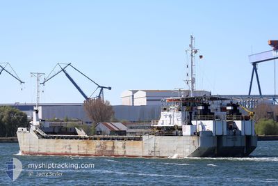
MAGELLANO 1800
Motor Hopper
Current Trip
| Time Travelled | 1 day |
|---|---|
| Remaining Time | --- |
| Distance Travelled | 188.59 nm |
| Remaining Distance | --- |
| AVG Speed | 6.4 Knots |
| MAX Speed | 9.6 Knots |
| AVG Wind | 12.8 knots |
| MAX Wind | 18.9 knots |
| MIN Temp | 10.5°C / 50.9°F |
| MAX Temp | 16.7°C / 62.06°F |
| Dybgang | 2.2 m |
| Position Modtaget | Nu |
Current Position
| Longitude | 12.11444° |
|---|---|
| Latitude | 54.29763° |
| Status | Under way using engine |
| Fart | 6.3 Knots |
| Kurs | 30.5° |
| Område | Baltic Sea |
| Station | T-AIS |
| Position Modtaget | Nu |
Info
Information
The current position of MAGELLANO 1800 is in Baltic Sea with coordinates 54.29763° / 12.11444° as reported on 2024-05-02 11:17 by AIS to our vessel tracker app. The vessel's current speed is 6.3 Knots
The vessel MAGELLANO 1800 (IMO: 7931002, MMSI: 645159000) is a Motor Hopper that was built in 1979 ( 45 år gamle ). It's sailing under the flag of [MU] Mauritius.
In this page you can find informations about the vessels current position, last detected port calls, and current voyage information. If the vessels is not in coverage by AIS you will find the latest position.
The current position of MAGELLANO 1800 is detected by our AIS receivers and we are not responsible for the reliability of the data. The last position was recorded while the vessel was in Coverage by the Ais receivers of our vessel tracking app.
The current draught of MAGELLANO 1800 as reported by AIS is 2.2 meters
Weather
| Temperature | 16.7°C / 62.06°F |
|---|---|
| Wind Speed | 12 knots |
| Direction | 106° ESE |
| Pressure | 1006.6 hPa |
| Humidity | 69.2 % |
| Cloud Coverage | 45 % |
Featured Company
Last Port Calls
| Port | Arrival | Departure | Time In Port |
|---|---|---|---|
| 2024-04-30 04:35 | 2024-04-30 15:58 | 11 h | |
| 2024-04-26 10:21 | 2024-04-26 17:31 | 7 h | |
| 2024-04-19 21:25 | 2024-04-20 04:21 | 6 h | |
| 2024-04-18 21:54 | 2024-04-19 07:59 | 10 h | |
| 2024-04-15 21:39 | 2024-04-16 09:49 | 12 h | |
| 2024-04-15 06:14 | 2024-04-15 17:22 | 11 h | |
| 2024-04-14 05:58 | 2024-04-15 03:06 | 21 h | |
| 2024-04-11 08:37 | 2024-04-11 13:41 | 5 h | |
| 2024-04-09 22:55 | 2024-04-10 14:00 | 15 h | |
| 2024-04-05 17:39 | 2024-04-06 04:59 | 11 h |
Last Trips
| Origin | Departure | Destination | Arrival | Distance | |
|---|---|---|---|---|---|
| 2024-04-26 19:31 | 2024-04-30 06:35 | 357.36 nm | |||
| 2024-04-20 06:21 | 2024-04-26 12:21 | 642.19 nm | |||
| 2024-04-19 09:59 | 2024-04-19 23:25 | 53.18 nm | |||
| 2024-04-16 11:49 | 2024-04-18 23:54 | 264.35 nm | |||
| 2024-04-15 19:22 | 2024-04-15 23:39 | 17.62 nm | |||
| 2024-04-15 05:06 | 2024-04-15 08:14 | 17.56 nm | |||
| 2024-04-11 15:41 | 2024-04-14 07:58 | 273.14 nm | |||
| 2024-04-10 16:00 | 2024-04-11 10:37 | 101.98 nm | |||
| 2024-04-06 06:59 | 2024-04-10 00:55 | 421.33 nm | |||
| 2024-04-05 06:50 | 2024-04-05 19:39 | 70.22 nm |
Events
| Tid | Hændelsen | Detaljer | Position / Dest | Info |
|---|---|---|---|---|
| 2024-05-02 10:40 | START Sejllads | 7.23 nm, North of ROSTOCK |
54.24599 / 12.05784
ROSTOCK
|
Fart: 5.1 kn Kurs: 70.6° |
| 2024-05-02 10:20 | STOP Sejllads | 7.28 nm, North of ROSTOCK |
54.24648 / 12.05471
ROSTOCK
|
Fart: 0.2 kn Kurs: 336° |
| 2024-05-02 09:40 | START Sejllads | 10.69 nm, North of ROSTOCK |
54.30497 / 12.12154
ROSTOCK
|
Fart: 3.1 kn Kurs: 333° |
| 2024-05-02 09:34 | STOP Sejllads | 10.8 nm, North of ROSTOCK |
54.30678 / 12.12203
ROSTOCK
|
Fart: 0.2 kn Kurs: 20° |
| 2024-05-02 08:52 | START Sejllads | 7.38 nm, North of ROSTOCK |
54.24815 / 12.05378
ROSTOCK
|
Fart: 4.5 kn Kurs: 21° |
| 2024-05-02 08:05 | STOP Sejllads | 7.27 nm, North of ROSTOCK |
54.24636 / 12.05479
ROSTOCK
|
Fart: 0.3 kn Kurs: 340° |
| 2024-05-02 07:24 | START Sejllads | 10.66 nm, North of ROSTOCK |
54.30460 / 12.11815
ROSTOCK
|
Fart: 3.1 kn Kurs: 199° |
| 2024-05-02 07:19 | STOP Sejllads | 10.77 nm, North of ROSTOCK |
54.30640 / 12.12036
ROSTOCK
|
Fart: 0.2 kn Kurs: 40° |
| 2024-05-02 06:39 | START Sejllads | 7.38 nm, North of ROSTOCK |
54.24811 / 12.05400
ROSTOCK
|
Fart: 4.7 kn Kurs: 11° |
| 2024-05-02 06:18 | STOP Sejllads | 7.27 nm, North of ROSTOCK |
54.24629 / 12.05484
ROSTOCK
|
Fart: 0.3 kn Kurs: 348° |