
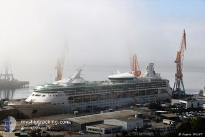
M/V RHAPSODY OTS
Passengers Ship
Current Trip
| Time Travelled | 8 h, 45 mins |
|---|---|
| Remaining Time | 1 h, 39 mins |
| Distance Travelled | 73.69 nm |
| Remaining Distance | 16.63 nm |
| AVG Speed | 8.4 Knots |
| MAX Speed | 9.1 Knots |
| AVG Wind | 8.4 knots |
| MAX Wind | 10.3 knots |
| MIN Temp | 25.4°C / 77.72°F |
| MAX Temp | 26.4°C / 79.52°F |
| Dybgang | 7.8 m |
| Position Modtaget | 1 m siden |
Current Position
| Longitude | --- |
|---|---|
| Latitude | --- |
| Status | Under way using engine |
| Fart | 9.3 Knots |
| Kurs | 163.3° |
| Område | Caribbean Sea |
| Station | T-AIS |
| Position Modtaget | 1 m siden |
Info
Information
The current position of M/V RHAPSODY OTS is in Caribbean Sea with coordinates 18.31536° / -65.15469° as reported on 2025-03-08 09:46 by AIS to our vessel tracker app. The vessel's current speed is 9.3 Knots and is heading at the port of ST THOMAS. The estimated time of arrival as calculated by MyShipTracking vessel tracking app is 2025-03-08 07:26 LT
The vessel M/V RHAPSODY OTS (IMO: 9116864, MMSI: 311805000) is a Passengers Ship that was built in 1997 ( 28 år gamle ). It's sailing under the flag of [BS] Bahamas.
In this page you can find informations about the vessels current position, last detected port calls, and current voyage information. If the vessels is not in coverage by AIS you will find the latest position.
The current position of M/V RHAPSODY OTS is detected by our AIS receivers and we are not responsible for the reliability of the data. The last position was recorded while the vessel was in Coverage by the Ais receivers of our vessel tracking app.
The current draught of M/V RHAPSODY OTS as reported by AIS is 7.8 meters
Weather
| Temperature | 26°C / 78.8°F |
|---|---|
| Wind Speed | 9 knots |
| Direction | 66° ENE |
| Pressure | 1015.3 hPa |
| Humidity | 76.3 % |
| Cloud Coverage | 1 % |
Featured Company
Last Port Calls
| Port | Arrival | Departure | Time In Port |
|---|---|---|---|
| 2025-03-07 05:21 | 2025-03-07 21:02 | 15 h | |
| 2025-03-05 09:12 | 2025-03-05 21:27 | 12 h | |
| 2025-02-28 08:43 | 2025-03-05 02:19 | 4 d | |
| 2025-02-26 05:21 | 2025-02-26 20:46 | 15 h | |
| 2025-02-23 07:11 | 2025-02-23 19:59 | 12 h | |
| 2025-02-20 07:16 | 2025-02-20 18:12 | 10 h | |
| 2025-02-19 06:36 | 2025-02-19 18:03 | 11 h | |
| 2025-02-17 07:46 | 2025-02-17 17:52 | 10 h | |
| 2025-02-16 05:19 | 2025-02-16 20:22 | 15 h | |
| 2025-02-14 07:10 | 2025-02-14 18:06 | 10 h |
Most Visited Ports (Last year)
| Port | Arrivals | |
|---|---|---|
| 45 | ||
| 43 | ||
| 37 | ||
| 31 | ||
| 28 | ||
| 16 |
Last Trips
| Origin | Departure | Destination | Arrival | Distance | |
|---|---|---|---|---|---|
| 2025-03-05 21:27 | 2025-03-07 05:21 | 596.87 nm | |||
| 2025-03-05 02:19 | 2025-03-05 09:12 | 95.84 nm | |||
| 2025-02-26 20:46 | 2025-02-28 08:43 | 584.23 nm | |||
| 2025-02-23 19:59 | 2025-02-26 05:21 | 568.49 nm | |||
| 2025-02-20 18:12 | 2025-02-23 07:11 | 578.19 nm | |||
| 2025-02-19 18:03 | 2025-02-20 07:16 | 97.50 nm | |||
| 2025-02-17 17:52 | 2025-02-19 06:36 | 199.44 nm | |||
| 2025-02-16 20:22 | 2025-02-17 07:46 | 113.78 nm | |||
| 2025-02-14 18:06 | 2025-02-16 05:19 | 511.64 nm | |||
| 2025-02-13 18:15 | 2025-02-14 07:10 | 110.98 nm |
Events
| Tid | Hændelsen | Detaljer | Position / Dest | Info |
|---|---|---|---|---|
| 2025-03-08 05:10 | Fundet i havområde | Puerto Rican part of the Caribbean Sea |
18.67567 / -65.62740
Caribbean Sea
PR SJU >>> VI STT
|
Fart: 8.4 kn Kurs: 97.2° |
| 2025-03-08 04:46 | Destination er ændret | PR SJU >>> VI STT TTSCA>>>PR SJU |
18.68301 / -65.68578
PR SJU >>> VI STT
|
Fart: 8.4 kn Kurs: 97.2° |
| 2025-03-08 04:46 | ETA er ændret | 2025/03/09 11:00 2025/03/07 09:00 |
18.68301 / -65.68578
PR SJU >>> VI STT
|
Fart: 8.4 kn Kurs: 97.2° |
| 2025-03-08 04:05 | Status er ændret | Under way using engine Default |
18.69509 / -65.78675
TTSCA>>>PR SJU
|
Fart: 8.5 kn Kurs: 97° |
| 2025-03-08 04:03 | Status er ændret | Default Under way using engine |
18.69572 / -65.79212
TTSCA>>>PR SJU
|
Fart: 8.5 kn Kurs: 96.3° |
| 2025-03-08 03:41 | Fundet i havområde | Puerto Rican part of the North Atlantic Ocean |
18.70210 / -65.84602
North Atlantic Ocean
|
Fart: 8.5 kn Kurs: 97.3° |
| 2025-03-08 03:40 | Status er ændret | Under way using engine Default |
18.70220 / -65.84685
TTSCA>>>PR SJU
|
Fart: 8.6 kn Kurs: 98° |
| 2025-03-08 03:21 | Indenfor Dækning |
18.70210 / -65.84602
North Atlantic Ocean
|
Fart: 8.5 kn Kurs: 97.3° |
|
| 2025-03-08 01:02 | Afsejlet fra sidste havn |
|
18.50117 / -66.12356
TTSCA>>>PR SJU
|
Fart: 10.5 kn Kurs: 350° |
| 2025-03-08 00:44 | START Sejllads |
18.45653 / -66.11597
[PR] SAN JUAN
|
Fart: 6.9 kn Kurs: 287° |