
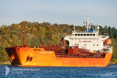
LUMPHINI PARK
Oil/Chemical Tanker
Current Trip
| Time Travelled | 9 days |
|---|---|
| Remaining Time | --- |
| Distance Travelled | 1405.94 nm |
| Remaining Distance | --- |
| AVG Speed | 10.9 Knots |
| MAX Speed | 14.8 Knots |
| AVG Wind | 10.8 knots |
| MAX Wind | 27.8 knots |
| MIN Temp | 10.9°C / 51.62°F |
| MAX Temp | 33.6°C / 92.48°F |
| Dybgang | 7 m |
| Position Modtaget | 18 h, 27 m siden |
Current Position
| Longitude | -57.76303° |
|---|---|
| Latitude | -34.73669° |
| Status | Under way using engine |
| Fart | 6.1 Knots |
| Kurs | 245.1° |
| Område | Rio de La Plata |
| Station | T-AIS |
| Position Modtaget | 18 h, 27 m siden |
Info
Information
The current position of LUMPHINI PARK is in Rio de La Plata with coordinates -34.73669° / -57.76303° as reported on 2024-05-02 11:05 by AIS to our vessel tracker app. The vessel's current speed is 6.1 Knots
The vessel LUMPHINI PARK (IMO: 9640114, MMSI: 636015589) is a Oil/Chemical Tanker that was built in 2013 ( 11 år gamle ). It's sailing under the flag of [LR] Liberia.
In this page you can find informations about the vessels current position, last detected port calls, and current voyage information. If the vessels is not in coverage by AIS you will find the latest position.
The current position of LUMPHINI PARK is detected by our AIS receivers and we are not responsible for the reliability of the data. The last position was recorded while the vessel was in Coverage by the Ais receivers of our vessel tracking app.
The current draught of LUMPHINI PARK as reported by AIS is 7 meters
Weather
| Temperature | 11.5°C / 52.7°F |
|---|---|
| Wind Speed | 4 knots |
| Direction | 203° SSW |
| Pressure | 1017.1 hPa |
| Humidity | 56.7 % |
| Cloud Coverage | --- |
Featured Company
Last Port Calls
| Port | Arrival | Departure | Time In Port |
|---|---|---|---|
| 2024-04-23 19:04 | 2024-04-23 19:51 | 46 m | |
| 2024-03-25 01:45 | 2024-03-26 14:23 | 1 d | |
| 2024-03-21 10:58 | 2024-03-23 15:49 | 2 d | |
| 2024-03-19 05:48 | 2024-03-20 01:05 | 19 h | |
| 2024-03-15 12:32 | 2024-03-16 18:58 | 1 d | |
| 2024-03-04 03:29 |
Most Visited Ports (Last year)
| Port | Arrivals | |
|---|---|---|
| 4 | ||
| 4 | ||
| 3 | ||
| 2 | ||
| 2 | ||
| 2 |
Last Trips
| Origin | Departure | Destination | Arrival | Distance | |
|---|---|---|---|---|---|
| 2024-03-26 09:23 | 2024-04-23 16:04 | 5625.08 nm | |||
| 2024-03-23 10:49 | 2024-03-24 20:45 | 415.18 nm | |||
| 2024-03-19 20:05 | 2024-03-21 05:58 | 112.88 nm | |||
| 2024-03-16 13:58 | 2024-03-19 00:48 | 63.94 nm | |||
| 2024-03-03 21:29 | 2024-03-15 07:32 | 662.63 nm |
Events
| Tid | Hændelsen | Detaljer | Position / Dest | Info |
|---|---|---|---|---|
| 2024-05-02 11:54 | STOP Sejllads | 7.7 nm, North East of LA PLATA |
-34.74655 / -57.79361
ARBUE
|
Fart: Kurs: 145° |
| 2024-05-02 11:07 | Status er ændret | Default Under way using engine |
-34.73838 / -57.76763
ARBUE
|
Fart: 6.1 kn Kurs: 245.1° |
| 2024-05-02 11:05 | Udenfor Dækning |
-34.73669 / -57.76303
Rio de La Plata
ARBUE
|
Fart: 6.1 kn Kurs: 245.1° |
|
| 2024-05-02 10:52 | Status er ændret | Under way using engine Default |
-34.73660 / -57.71528
ARBUE
|
Fart: 14 kn Kurs: 285° |
| 2024-05-02 10:38 | Indenfor Dækning |
-34.73654 / -57.71688
Rio de La Plata
ARBUE
|
Fart: 13.6 kn Kurs: 272.3° |
|
| 2024-05-02 09:32 | Status er ændret | Default Under way using engine |
-34.85073 / -57.37276
ARBUE
|
Fart: 14.1 kn Kurs: 308.2° |
| 2024-05-02 09:25 | Ændre havområde | Argentinean part of the Rio de La Plata Uruguayan part of the Rio de La Plata |
-34.86561 / -57.34549
Rio de La Plata
ARBUE
|
Fart: 14.1 kn Kurs: 308.2° |
| 2024-05-02 09:25 | Udenfor Dækning |
-34.86561 / -57.34549
Rio de La Plata
ARBUE
|
Fart: 14.1 kn Kurs: 308.2° |
|
| 2024-05-02 09:25 | Status er ændret | Under way using engine Default |
-34.86608 / -57.34474
ARBUE
|
Fart: 14.2 kn Kurs: 318° |
| 2024-05-02 09:25 | Indenfor Dækning |
-34.86561 / -57.34549
Rio de La Plata
ARBUE
|
Fart: 14.1 kn Kurs: 308.2° |