
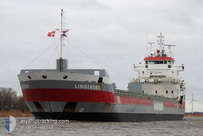
LINGEBORG
General Cargo
Current Trip
| Trip Time | 11 h, 4 mins |
|---|---|
| Trip Distance | 118.58 nm |
| AVG Speed | 10.1 Knots |
| MAX Speed | 15.1 Knots |
| Dybgang | 4.1 m |
| AVG Wind | 7 knots |
| MAX Wind | 12 knots |
| MIN Temp | 11.5°C / 52.7°F |
| MAX Temp | 15.1°C / 59.18°F |
| Position Modtaget | Nu |
Current Position
| Longitude | 1.57254° |
|---|---|
| Latitude | 50.72297° |
| Status | Moored |
| Fart | |
| Kurs | 196° |
| Område | English Channel |
| Station | T-AIS |
| Position Modtaget | Nu |
Info
Information
The current position of LINGEBORG is in English Channel with coordinates 50.72297° / 1.57254° as reported on 2024-05-02 03:43 by AIS to our vessel tracker app. The vessel's current speed is 0 Knots and is currently inside the port of BOULOGNE-SUR-MER.
The vessel LINGEBORG (IMO: 9399399, MMSI: 245046000) is a General Cargo that was built in 2007 ( 17 år gamle ). It's sailing under the flag of [NL] Netherlands.
In this page you can find informations about the vessels current position, last detected port calls, and current voyage information. If the vessels is not in coverage by AIS you will find the latest position.
The current position of LINGEBORG is detected by our AIS receivers and we are not responsible for the reliability of the data. The last position was recorded while the vessel was in Coverage by the Ais receivers of our vessel tracking app.
The current draught of LINGEBORG as reported by AIS is 4.1 meters
Weather
| Temperature | 11.5°C / 52.7°F |
|---|---|
| Wind Speed | 5 knots |
| Direction | 6° N |
| Pressure | 999.9 hPa |
| Humidity | 96.7 % |
| Cloud Coverage | 100 % |
Featured Company
Last Port Calls
| Port | Arrival | Departure | Time In Port |
|---|---|---|---|
| 2024-05-01 09:17 | |||
| 2024-04-29 13:18 | 2024-04-30 22:13 | 1 d | |
| 2024-04-24 04:00 | 2024-04-24 19:57 | 15 h | |
| 2024-04-22 05:43 | 2024-04-22 20:48 | 15 h | |
| 2024-04-18 10:40 | 2024-04-19 22:28 | 1 d | |
| 2024-04-15 23:03 | 2024-04-17 09:40 | 1 d | |
| 2024-04-10 09:10 | 2024-04-11 21:13 | 1 d | |
| 2024-04-07 10:15 | 2024-04-09 22:28 | 2 d | |
| 2024-03-10 04:46 | 2024-04-01 20:28 | 22 d | |
| 2024-03-05 01:32 |
Last Trips
| Origin | Departure | Destination | Arrival | Distance | |
|---|---|---|---|---|---|
| 2024-05-01 00:13 | 2024-05-01 11:17 | 118.58 nm | |||
| 2024-04-24 22:57 | 2024-04-29 15:18 | 1017.55 nm | |||
| 2024-04-22 23:48 | 2024-04-24 07:00 | 335.87 nm | |||
| 2024-04-20 01:28 | 2024-04-22 08:43 | 321.64 nm | |||
| 2024-04-17 12:40 | 2024-04-18 13:40 | 212.03 nm | |||
| 2024-04-11 23:13 | 2024-04-16 02:03 | 943.80 nm | |||
| 2024-04-10 00:28 | 2024-04-10 11:10 | 107.90 nm | |||
| 2024-04-01 23:28 | 2024-04-07 12:15 | 1331.07 nm | |||
| 2024-03-05 02:32 | 2024-03-10 06:46 | 1418.91 nm |
Events
| Tid | Hændelsen | Detaljer | Position / Dest | Info |
|---|---|---|---|---|
| 2024-05-01 10:22 | Status er ændret | Moored Under way using engine |
50.72299 / 1.57250
[FR] BOULOGNE-SUR-MER
|
Fart: Kurs: 196° |
| 2024-05-01 09:31 | STOP Sejllads |
50.72311 / 1.57264
[FR] BOULOGNE-SUR-MER
|
Fart: 0.3 kn Kurs: 197° |
|
| 2024-05-01 09:17 | Skibe i havn |
|
50.73064 / 1.57656
[FR] BOULOGNE-SUR-MER
|
Fart: 4.9 kn Kurs: 177° |
| 2024-05-01 06:50 | Ændre havområde | French part of the English Channel United Kingdom part of the English Channel |
51.00137 / 1.49117
English Channel
FRBOL
|
Fart: 11 kn Kurs: 131.8° |
| 2024-05-01 06:26 | Ændre havområde | United Kingdom part of the English Channel United Kingdom part of the North Sea |
51.05110 / 1.51428
English Channel
FRBOL
|
Fart: 10.4 kn Kurs: 225.8° |
| 2024-05-01 03:11 | Ændre havområde | United Kingdom part of the North Sea French part of the North Sea |
51.39867 / 2.06491
North Sea
FRBOL
|
Fart: 10.8 kn Kurs: 296.6° |
| 2024-05-01 02:09 | Fundet i havområde | French part of the North Sea |
51.35584 / 2.33780
North Sea
FRBOL
|
Fart: 11.1 kn Kurs: 253° |
| 2024-04-30 23:07 | Ændre havområde | Belgian part of the North Sea Dutch part of the North Sea |
51.40875 / 3.32758
North Sea
FRBOL
|
Fart: 14.1 kn Kurs: 267.3° |
| 2024-04-30 22:16 | Status er ændret | Under way using engine Moored |
51.44309 / 3.65745
FRBOL
|
Fart: 13.9 kn Kurs: 258° |
| 2024-04-30 22:13 | Afsejlet fra sidste havn |
|
51.44702 / 3.67069
FRBOL
|
Fart: 11.8 kn Kurs: 209° |