
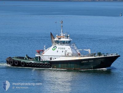
LINDSEY FOSS
Tug
Current Trip
| Time Travelled | 1 h, 4 mins |
|---|---|
| Remaining Time | 1 h, 2 mins |
| Distance Travelled | 11.78 nm |
| Remaining Distance | 16.25 nm |
| AVG Speed | 12.2 Knots |
| MAX Speed | 12.9 Knots |
| AVG Wind | 3.9 knots |
| MAX Wind | 4.3 knots |
| MIN Temp | 6.9°C / 44.42°F |
| MAX Temp | 7.2°C / 44.96°F |
| Dybgang | 7 m |
| Position Modtaget | 1 m siden |
Current Position
| Longitude | --- |
|---|---|
| Latitude | --- |
| Status | Under way using engine |
| Fart | 11.3 Knots |
| Kurs | 196° |
| Område | The Coastal Waters of Southeast Alaska and British Columbia |
| Station | T-AIS |
| Position Modtaget | 1 m siden |
Info
Information
The current position of LINDSEY FOSS is in The Coastal Waters of Southeast Alaska and British Columbia with coordinates 47.81475° / -122.41040° as reported on 2026-01-05 21:51 by AIS to our vessel tracker app. The vessel's current speed is 11.3 Knots and is heading at the port of SEATTLE. The estimated time of arrival as calculated by MyShipTracking vessel tracking app is 2026-01-05 14:54 LT
The vessel LINDSEY FOSS (IMO: 9070254, MMSI: 366767150) is a Tug that was built in 1993 ( 33 år gamle ). It's sailing under the flag of [US] USA.
In this page you can find informations about the vessels current position, last detected port calls, and current voyage information. If the vessels is not in coverage by AIS you will find the latest position.
The current position of LINDSEY FOSS is detected by our AIS receivers and we are not responsible for the reliability of the data. The last position was recorded while the vessel was in Coverage by the Ais receivers of our vessel tracking app.
The current draught of LINDSEY FOSS as reported by AIS is 7 meters
Weather
| Temperature | 7.1°C / 44.78°F |
|---|---|
| Wind Speed | 4 knots |
| Direction | 172° S |
| Pressure | 1014.5 hPa |
| Humidity | 79.3 % |
| Cloud Coverage | 97 % |
Featured Company
Last Port Calls
| Port | Arrival | Departure | Time In Port |
|---|---|---|---|
| 2026-01-05 10:43 | 2026-01-05 12:48 | 2 h | |
| 2026-01-04 19:07 | 2026-01-04 19:46 | 38 m | |
| 2026-01-04 06:46 | 2026-01-04 07:31 | 45 m | |
| 2026-01-04 05:52 | 2026-01-04 06:43 | 51 m | |
| 2026-01-04 03:32 | 2026-01-04 04:13 | 41 m | |
| 2026-01-03 11:09 | 2026-01-03 12:00 | 51 m | |
| 2026-01-02 21:10 | 2026-01-03 07:29 | 10 h | |
| 2026-01-02 15:12 | 2026-01-02 20:49 | 5 h | |
| 2026-01-02 07:03 | 2026-01-02 08:25 | 1 h | |
| 2026-01-02 05:01 | 2026-01-02 05:52 | 51 m |
Most Visited Ports (Last year)
| Port | Arrivals | |
|---|---|---|
| 372 | ||
| 111 | ||
| 89 | ||
| 66 | ||
| 66 | ||
| 54 |
Last Trips
| Origin | Departure | Destination | Arrival | Distance | |
|---|---|---|---|---|---|
| 2026-01-04 19:46 | 2026-01-05 10:43 | 98.99 nm | |||
| 2026-01-04 07:31 | 2026-01-04 19:07 | 88.27 nm | |||
| 2026-01-04 06:43 | 2026-01-04 06:46 | 0.21 nm | |||
| 2026-01-04 04:13 | 2026-01-04 05:52 | 6.03 nm | |||
| 2026-01-03 12:00 | 2026-01-04 03:32 | 22.64 nm | |||
| 2026-01-03 07:29 | 2026-01-03 11:09 | 41.87 nm | |||
| 2026-01-02 20:49 | 2026-01-02 21:10 | 2.38 nm | |||
| 2026-01-02 08:25 | 2026-01-02 15:12 | 58.73 nm | |||
| 2026-01-02 05:52 | 2026-01-02 07:03 | 5.10 nm | |||
| 2026-01-01 22:04 | 2026-01-02 05:01 | 1.65 nm |
Events
| Tid | Hændelsen | Detaljer | Position / Dest | Info |
|---|---|---|---|---|
| 2026-01-05 21:06 | Destination er ændret | SEATTLE EVERETT |
47.95435 / -122.31078
SEATTLE
|
Fart: 12 kn Kurs: 226° |
| 2026-01-05 21:06 | ETA er ændret | 2026/01/05 23:00 2026/01/05 19:00 |
47.95435 / -122.31078
SEATTLE
|
Fart: 12 kn Kurs: 226° |
| 2026-01-05 20:56 | Destination er ændret | EVERETT SEATTLE |
47.96755 / -122.26632
EVERETT
|
Fart: 12 kn Kurs: 251° |
| 2026-01-05 20:56 | ETA er ændret | 2026/01/05 19:00 2026/01/05 23:00 |
47.96755 / -122.26632
EVERETT
|
Fart: 12 kn Kurs: 251° |
| 2026-01-05 20:54 | Destination er ændret | SEATTLE EVERETT |
47.96962 / -122.25752
SEATTLE
|
Fart: 11.8 kn Kurs: 248.5° |
| 2026-01-05 20:54 | ETA er ændret | 2026/01/05 23:00 2026/01/05 19:00 |
47.96962 / -122.25752
SEATTLE
|
Fart: 11.8 kn Kurs: 248.5° |
| 2026-01-05 20:49 | Destination er ændret | EVERETT SEATTLE |
47.97415 / -122.23809
EVERETT
|
Fart: 10.4 kn Kurs: 251.5° |
| 2026-01-05 20:49 | ETA er ændret | 2026/01/05 19:00 2026/01/05 23:00 |
47.97415 / -122.23809
EVERETT
|
Fart: 10.4 kn Kurs: 251.5° |
| 2026-01-05 20:48 | Afsejlet fra sidste havn |
|
47.97483 / -122.23525
SEATTLE
|
Fart: 10 kn Kurs: 252° |
| 2026-01-05 20:48 | Destination er ændret | SEATTLE EVERETT |
47.97552 / -122.23173
[US] EVERETT
|
Fart: 9.4 kn Kurs: 253° |