
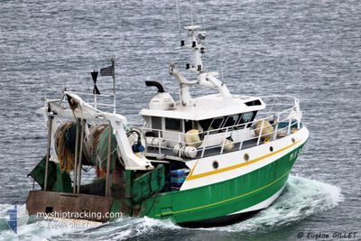
LE PRELUDE
Fishing
Current Trip
BREST
Unknown Port
ETA*
---
| Time Travelled | --- |
|---|---|
| Remaining Time | --- |
| Distance Travelled | 243.59 nm |
| Remaining Distance | --- |
| AVG Speed | 4.7 Knots |
| MAX Speed | 9.5 Knots |
| AVG Wind | 13.2 knots |
| MAX Wind | 24.8 knots |
| MIN Temp | 12.1°C / 53.78°F |
| MAX Temp | 17.7°C / 63.86°F |
| Dybgang | 0 m |
| Position Modtaget | 2 m siden |
Current Position
| Longitude | --- |
|---|---|
| Latitude | --- |
| Status | Engaged in Fishing |
| Fart | 7.6 Knots |
| Kurs | 220.5° |
| Område | English Channel |
| Station | T-AIS |
| Position Modtaget | 2 m siden |
Info
info
Information
The current position of LE PRELUDE is in English Channel with coordinates 49.63737° / -0.54132° as reported on 2024-10-07 06:48 by AIS to our vessel tracker app. The vessel's current speed is 7.6 Knots
The vessel LE PRELUDE (MMSI: 227127800) is a Fishing It's sailing under the flag of [FR] France.
In this page you can find informations about the vessels current position, last detected port calls, and current voyage information. If the vessels is not in coverage by AIS you will find the latest position.
The current position of LE PRELUDE is detected by our AIS receivers and we are not responsible for the reliability of the data. The last position was recorded while the vessel was in Coverage by the Ais receivers of our vessel tracking app.
Weather
| Temperature | 15.2°C / 59.36°F |
|---|---|
| Wind Speed | 19 knots |
| Direction | 215° SW |
| Pressure | 1000 hPa |
| Humidity | 79.6 % |
| Cloud Coverage | 56 % |
Featured Company
Limited time offer - Install a base station receiver to your area and list your company on MyShipTracking Free forever!
Last Port Calls
Most Visited Ports (Last year)
| Port | Arrivals | |
|---|---|---|
| 17 | ||
| 1 |
Last Trips
| Origin | Departure | Destination | Arrival | Distance |
|---|
Events
| Tid | Hændelsen | Detaljer | Position / Dest | Info |
|---|---|---|---|---|
| 2024-10-07 00:55 | START Sejllads | 19.53 nm, West of ANTIFER |
49.74164 / -.34757
BREST
|
Fart: 4.2 kn Kurs: 256.2° |
| 2024-10-07 00:51 | STOP Sejllads | 19.39 nm, West of ANTIFER |
49.74155 / -.34386
BREST
|
Fart: 0.2 kn Kurs: 511° |
| 2024-10-06 23:30 | START Sejllads | 16.59 nm, West of ANTIFER |
49.74353 / -.26800
BREST
|
Fart: 3.5 kn Kurs: 267.8° |
| 2024-10-06 23:26 | STOP Sejllads | 16.48 nm, West of ANTIFER |
49.74368 / -.26502
BREST
|
Fart: 0.3 kn Kurs: 511° |
| 2024-10-06 23:15 | START Sejllads | 16.15 nm, West of ANTIFER |
49.74429 / -.25573
BREST
|
Fart: 3.6 kn Kurs: 256.3° |
| 2024-10-06 23:11 | STOP Sejllads | 16.05 nm, West of ANTIFER |
49.74472 / -.25279
BREST
|
Fart: 0.3 kn Kurs: 511° |
| 2024-10-06 22:56 | START Sejllads | 15.62 nm, West of ANTIFER |
49.74539 / -.24073
BREST
|
Fart: 3.9 kn Kurs: 271° |
| 2024-10-06 22:45 | STOP Sejllads | 15.32 nm, West of ANTIFER |
49.74609 / -.23216
BREST
|
Fart: 0.3 kn Kurs: 511° |
| 2024-10-06 22:42 | START Sejllads | 15.24 nm, West of ANTIFER |
49.74631 / -.22997
BREST
|
Fart: 3.1 kn Kurs: 250.9° |
| 2024-10-06 22:38 | STOP Sejllads | 15.15 nm, West of ANTIFER |
49.74699 / -.22700
BREST
|
Fart: 0.2 kn Kurs: 511° |