
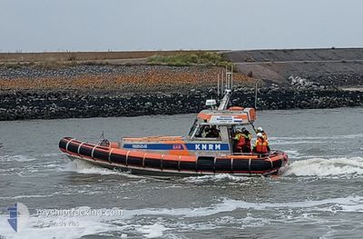
KNRM-WIECHER JAP VP
Search and Rescue vessel
Current Trip
ON DUTY
| Time Travelled | 32 days |
|---|---|
| Remaining Time | --- |
| Distance Travelled | 49.43 nm |
| Remaining Distance | --- |
| AVG Speed | 22.9 Knots |
| MAX Speed | 22.9 Knots |
| AVG Wind | 9 knots |
| MAX Wind | 16 knots |
| MIN Temp | -0.6°C / 30.92°F |
| MAX Temp | 14.9°C / 58.82°F |
| Dybgang | 0.8 m |
| Position Modtaget | 13 h, 22 m siden |
Current Position
| Longitude | --- |
|---|---|
| Latitude | --- |
| Status | Under way using engine |
| Fart | |
| Kurs | --- |
| Område | North Sea |
| Station | T-AIS |
| Position Modtaget | 13 h, 22 m siden |
Info
Information
The current position of KNRM-WIECHER JAP VP is in North Sea with coordinates 52.64145° / 5.09017° as reported on 2025-03-17 10:29 by AIS to our vessel tracker app. The vessel's current speed is 0 Knots
The vessel KNRM-WIECHER JAP VP (MMSI: 244318000) is a Search and Rescue vessel It's sailing under the flag of [NL] Netherlands.
In this page you can find informations about the vessels current position, last detected port calls, and current voyage information. If the vessels is not in coverage by AIS you will find the latest position.
The current position of KNRM-WIECHER JAP VP is detected by our AIS receivers and we are not responsible for the reliability of the data. The last position was recorded while the vessel was in Coverage by the Ais receivers of our vessel tracking app.
The current draught of KNRM-WIECHER JAP VP as reported by AIS is 0.8 meters
Weather
| Temperature | 5°C / 41°F |
|---|---|
| Wind Speed | 14 knots |
| Direction | 81° E |
| Pressure | 1030.7 hPa |
| Humidity | 66.4 % |
| Cloud Coverage | 40 % |
Featured Company
Most Visited Ports (Last year)
| Port | Arrivals | |
|---|---|---|
| 126 | ||
| 4 | ||
| 2 |
Last Trips
Events
| Tid | Hændelsen | Detaljer | Position / Dest | Info |
|---|---|---|---|---|
| 2025-03-17 10:29 | Udenfor Dækning |
52.64145 / 5.09017
North Sea
|
Fart: Kurs: 21.8° |
|
| 2025-03-17 10:14 | Indenfor Dækning |
52.64161 / 5.09013
North Sea
|
Fart: Kurs: 313.3° |
|
| 2025-03-14 10:48 | Udenfor Dækning |
52.64151 / 5.09015
North Sea
|
Fart: Kurs: 36.1° |
|
| 2025-03-14 08:37 | Indenfor Dækning |
52.64155 / 5.09041
North Sea
|
Fart: Kurs: 329.4° |
|
| 2025-03-12 07:59 | Udenfor Dækning |
52.64151 / 5.09003
North Sea
|
Fart: Kurs: 21.6° |
|
| 2025-03-12 06:34 | Indenfor Dækning |
52.64144 / 5.09023
North Sea
|
Fart: Kurs: 244.1° |
|
| 2025-03-11 15:58 | Udenfor Dækning |
52.64162 / 5.09007
North Sea
|
Fart: Kurs: 246.5° |
|
| 2025-03-11 06:34 | Indenfor Dækning |
52.64127 / 5.09007
North Sea
|
Fart: 0.1 kn Kurs: 285.8° |
|
| 2025-03-10 15:54 | Udenfor Dækning |
52.64169 / 5.09027
North Sea
|
Fart: Kurs: 71.1° |
|
| 2025-03-10 10:05 | Indenfor Dækning |
52.64145 / 5.09017
North Sea
|
Fart: Kurs: 112.8° |