
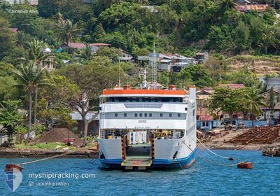
KMP.BRR
Passenger
Current Trip
ULEE-LHEUE - BALOHAN
| Time Travelled | 4 h, 37 mins |
|---|---|
| Remaining Time | --- |
| Distance Travelled | 1.75 nm |
| Remaining Distance | --- |
| AVG Speed | --- |
| MAX Speed | --- |
| AVG Wind | 4.8 knots |
| MAX Wind | 5 knots |
| MIN Temp | 26.9°C / 80.42°F |
| MAX Temp | 27°C / 80.6°F |
| Dybgang | 2.8 m |
| Position Modtaget | 2024-11-04 02:48 |
Current Position
| Longitude | --- |
|---|---|
| Latitude | --- |
| Status | Under way using engine |
| Fart | 4.8 Knots |
| Kurs | 0.5° |
| Område | Andaman or Burma Sea |
| Station | T-AIS |
| Position Modtaget | 2024-11-04 02:48 |
Information
The current position of KMP.BRR is in Andaman or Burma Sea with coordinates 5.82351° / 95.34671° as reported on 2024-11-04 02:48 by AIS to our vessel tracker app. The vessel's current speed is 4.8 Knots
The vessel KMP.BRR (IMO: 9549475, MMSI: 525015336) is a Passenger It's sailing under the flag of [ID] Indonesia.
In this page you can find informations about the vessels current position, last detected port calls, and current voyage information. If the vessels is not in coverage by AIS you will find the latest position.
The current position of KMP.BRR is detected by our AIS receivers and we are not responsible for the reliability of the data. The last position was recorded while the vessel was in Coverage by the Ais receivers of our vessel tracking app.
The current draught of KMP.BRR as reported by AIS is 2.8 meters
Weather
| Temperature | 26.7°C / 80.06°F |
|---|---|
| Wind Speed | 4 knots |
| Direction | 69° ENE |
| Pressure | 1010.6 hPa |
| Humidity | 79.1 % |
| Cloud Coverage | 100 % |
Featured Company
Last Port Calls
| Port | Arrival | Departure | Time In Port |
|---|---|---|---|
| 2025-03-29 10:18 | 2025-03-30 01:26 | 15 h | |
| 2025-03-29 02:42 | 2025-03-29 05:26 | 2 h | |
| 2025-03-28 05:46 | 2025-03-28 09:25 | 3 h | |
| 2025-03-27 10:14 | 2025-03-28 01:26 | 15 h | |
| 2025-03-27 02:46 | 2025-03-27 05:18 | 2 h | |
| 2025-03-26 06:50 | 2025-03-26 08:50 | 1 h | |
| 2025-03-25 10:38 | 2025-03-26 01:22 | 14 h | |
| 2025-03-25 02:46 | 2025-03-25 05:34 | 2 h | |
| 2025-03-24 06:54 | 2025-03-24 08:50 | 1 h | |
| 2025-03-23 10:30 | 2025-03-24 01:34 | 15 h |
Most Visited Ports (Last year)
| Port | Arrivals | |
|---|---|---|
| 490 |
Last Trips
| Origin | Departure | Destination | Arrival | Distance | |
|---|---|---|---|---|---|
| 2025-03-29 12:26 | 2025-03-29 17:18 | 30.96 nm | |||
| 2025-03-28 16:25 | 2025-03-29 09:42 | 30.84 nm | |||
| 2025-03-28 08:26 | 2025-03-28 12:46 | 31.16 nm | |||
| 2025-03-27 12:18 | 2025-03-27 17:14 | 31.67 nm | |||
| 2025-03-26 15:50 | 2025-03-27 09:46 | 29.95 nm | |||
| 2025-03-26 08:22 | 2025-03-26 13:50 | 31.46 nm | |||
| 2025-03-25 12:34 | 2025-03-25 17:38 | 29.35 nm | |||
| 2025-03-24 15:50 | 2025-03-25 09:46 | 31.48 nm | |||
| 2025-03-24 08:34 | 2025-03-24 13:54 | 31.50 nm | |||
| 2025-03-23 12:17 | 2025-03-23 17:30 | 31.85 nm |
Events
| Tid | Hændelsen | Detaljer | Position / Dest | Info |
|---|---|---|---|---|
| 2025-03-30 05:38 | START Sejllads | 8.27 nm, South of SABANG |
5.74893 / 95.34120
ULEE-LHEUE - BALOHAN
|
Fart: 11.6 kn Kurs: 198° |
| 2025-03-30 01:26 | Afsejlet fra sidste havn |
|
5.57757 / 95.29568
ULEE-LHEUE - BALOHAN
|
Fart: 5.7 kn Kurs: -1° |
| 2025-03-30 01:22 | START Sejllads |
5.56824 / 95.29645
[ID] BANDA ACEH
|
Fart: 5.7 kn Kurs: -1° |
|
| 2025-03-29 10:22 | STOP Sejllads |
5.56476 / 95.29530
[ID] BANDA ACEH
|
Fart: 0.3 kn Kurs: -1° |
|
| 2025-03-29 10:18 | Skibe i havn |
|
5.56739 / 95.29663
[ID] BANDA ACEH
|
Fart: 9.8 kn Kurs: 178° |
| 2025-03-29 08:49 | START Sejllads | 4.88 nm, South East of SABANG |
5.81094 / 95.35197
ULEE-LHEUE - BALOHAN
|
Fart: 10.4 kn Kurs: 168° |
| 2025-03-29 07:14 | STOP Sejllads | 3.95 nm, South East of SABANG |
5.82584 / 95.34717
ULEE-LHEUE - BALOHAN
|
Fart: Kurs: -1° |
| 2025-03-29 05:26 | Afsejlet fra sidste havn |
|
5.58303 / 95.29630
ULEE-LHEUE - BALOHAN
|
Fart: 9.3 kn Kurs: -1° |
| 2025-03-29 05:22 | START Sejllads |
5.57288 / 95.29572
[ID] BANDA ACEH
|
Fart: 9.3 kn Kurs: -1° |
|
| 2025-03-29 02:50 | STOP Sejllads |
5.56469 / 95.29512
[ID] BANDA ACEH
|
Fart: Kurs: -1° |