
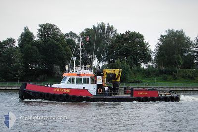
KATRINE
Pusher Tug
Current Trip
LAG0S LADOL
| Time Travelled | 9 days |
|---|---|
| Remaining Time | --- |
| Distance Travelled | 95.53 nm |
| Remaining Distance | --- |
| AVG Speed | 7.1 Knots |
| MAX Speed | 8.4 Knots |
| AVG Wind | 5.1 knots |
| MAX Wind | 12.8 knots |
| MIN Temp | 24.2°C / 75.56°F |
| MAX Temp | 37.3°C / 99.14°F |
| Dybgang | 2.6 m |
| Position Modtaget | 2023-12-25 08:50 |
Current Position
| Longitude | 3.44714° |
|---|---|
| Latitude | 6.41326° |
| Status | At anchor |
| Fart | |
| Kurs | --- |
| Område | Gulf of Guinea |
| Station | T-AIS |
| Position Modtaget | 2023-12-25 08:50 |
Info
Information
The current position of KATRINE is in Gulf of Guinea with coordinates 6.41326° / 3.44714° as reported on 2023-12-25 08:50 by AIS to our vessel tracker app. The vessel's current speed is 0 Knots
The vessel KATRINE (IMO: 9280457, MMSI: 657190000) is a Pusher Tug that was built in 2002 ( 22 år gamle ). It's sailing under the flag of [NG] Nigeria.
In this page you can find informations about the vessels current position, last detected port calls, and current voyage information. If the vessels is not in coverage by AIS you will find the latest position.
The current position of KATRINE is detected by our AIS receivers and we are not responsible for the reliability of the data. The last position was recorded while the vessel was in Coverage by the Ais receivers of our vessel tracking app.
The current draught of KATRINE as reported by AIS is 2.6 meters
Weather
| Temperature | 27.2°C / 80.96°F |
|---|---|
| Wind Speed | 4 knots |
| Direction | 241° WSW |
| Pressure | 1009.3 hPa |
| Humidity | 87.8 % |
| Cloud Coverage | 100 % |
Featured Company
Last Port Calls
| Port | Arrival | Departure | Time In Port |
|---|---|---|---|
| 2024-04-21 16:32 | 2024-04-22 10:00 | 17 h | |
| 2024-04-21 15:23 | 2024-04-21 15:28 | 5 m | |
| 2024-04-21 14:39 | 2024-04-21 14:44 | 4 m | |
| 2024-04-21 13:28 | 2024-04-21 13:40 | 11 m | |
| 2024-04-21 08:15 | 2024-04-21 08:36 | 21 m | |
| 2024-04-20 14:44 | 2024-04-21 07:08 | 16 h | |
| 2024-04-20 10:13 | 2024-04-20 11:52 | 1 h | |
| 2024-04-19 17:04 | 2024-04-20 06:16 | 13 h | |
| 2024-04-17 15:52 | 2024-04-19 15:52 | 2 d | |
| 2024-04-17 07:07 | 2024-04-17 13:44 | 6 h |
Last Trips
| Origin | Departure | Destination | Arrival | Distance | |
|---|---|---|---|---|---|
| 2024-04-21 16:28 | 2024-04-21 17:32 | 2.87 nm | |||
| 2024-04-21 15:44 | 2024-04-21 16:23 | 1.47 nm | |||
| 2024-04-21 14:40 | 2024-04-21 15:39 | 1.94 nm | |||
| 2024-04-21 09:36 | 2024-04-21 14:28 | 4.65 nm | |||
| 2024-04-21 08:08 | 2024-04-21 09:15 | 0.98 nm | |||
| 2024-04-20 12:52 | 2024-04-20 15:44 | 1.60 nm | |||
| 2024-04-20 07:16 | 2024-04-20 11:13 | 2.34 nm | |||
| 2024-04-19 16:52 | 2024-04-19 18:04 | 2.60 nm | |||
| 2024-04-17 14:44 | 2024-04-17 16:52 | 0.35 nm | |||
| 2024-04-17 07:40 | 2024-04-17 08:07 | 0.87 nm |
Events
| Tid | Hændelsen | Detaljer | Position / Dest | Info |
|---|---|---|---|---|
| 2024-04-22 13:08 | STOP Sejllads | 7.88 nm, North West of ONNE |
4.74978 / 7.04361
LAG0S LADOL
|
Fart: 0.3 kn Kurs: -1° |
| 2024-04-22 13:04 | START Sejllads | 7.91 nm, North West of ONNE |
4.75084 / 7.04360
LAG0S LADOL
|
Fart: 3.8 kn Kurs: -1° |
| 2024-04-22 11:36 | STOP Sejllads | 7.7 nm, North West of ONNE |
4.75163 / 7.04810
LAG0S LADOL
|
Fart: 0.1 kn Kurs: -1° |
| 2024-04-22 10:04 | START Sejllads | 1.61 nm, South of ONNE |
4.65798 / 7.15107
LAG0S LADOL
|
Fart: 7.1 kn Kurs: 193° |
| 2024-04-22 10:00 | Afsejlet fra sidste havn |
|
4.66267 / 7.15275
LAG0S LADOL
|
Fart: 0.6 kn Kurs: -1° |