
JAMAICA
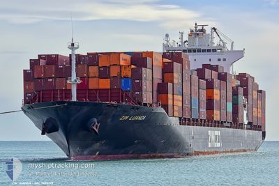
Container Ship
Current Trip
| Time Travelled | 3 days |
|---|---|
| Remaining Time | 13 mins |
| Distance Travelled | 1687.78 nm |
| Remaining Distance | 6.21 nm |
| AVG Speed | 18.2 Knots |
| MAX Speed | 20.8 Knots |
| AVG Wind | 7.7 knots |
| MAX Wind | 23 knots |
| MIN Temp | 15.2°C / 59.36°F |
| MAX Temp | 19.1°C / 66.38°F |
| Dybgang | 10.8 m |
| Position Modtaget | Nu |
Current Position
| Longitude | --- |
|---|---|
| Latitude | --- |
| Status | Under way using engine |
| Fart | 3.3 Knots |
| Kurs | 152° |
| Område | Mediterranean Sea - Eastern Basin |
| Station | T-AIS |
| Position Modtaget | Nu |
Info
Information
The current position of JAMAICA is in Mediterranean Sea - Eastern Basin with coordinates 32.91235° / 34.97946° as reported on 2025-12-11 16:57 by AIS to our vessel tracker app. The vessel's current speed is 3.3 Knots and is heading at the port of HAIFA. The estimated time of arrival as calculated by MyShipTracking vessel tracking app is 2025-12-11 19:11 LT
The vessel JAMAICA (IMO: 9403229, MMSI: 249830000) is a Container Ship that was built in 2009 ( 16 år gamle ). It's sailing under the flag of [MT] Malta.
In this page you can find informations about the vessels current position, last detected port calls, and current voyage information. If the vessels is not in coverage by AIS you will find the latest position.
The current position of JAMAICA is detected by our AIS receivers and we are not responsible for the reliability of the data. The last position was recorded while the vessel was in Coverage by the Ais receivers of our vessel tracking app.
The current draught of JAMAICA as reported by AIS is 10.8 meters
Weather
| Temperature | 17°C / 62.6°F |
|---|---|
| Wind Speed | 8 knots |
| Direction | 166° SSE |
| Pressure | 1013.4 hPa |
| Humidity | 73 % |
| Cloud Coverage | 100 % |
Featured Company
Last Port Calls
| Port | Arrival | Departure | Time In Port |
|---|---|---|---|
| 2025-12-07 10:50 | 2025-12-08 01:02 | 14 h | |
| 2025-12-05 00:44 | 2025-12-06 04:15 | 1 d | |
| 2025-11-23 00:35 | 2025-11-24 18:51 | 1 d | |
| 2025-11-19 02:54 | 2025-11-19 20:08 | 17 h | |
| 2025-11-15 03:11 | 2025-11-15 14:52 | 11 h | |
| 2025-11-13 04:26 | 2025-11-13 23:38 | 19 h | |
| 2025-11-10 12:02 | 2025-11-11 09:50 | 21 h | |
| 2025-10-30 17:57 | 2025-10-31 07:32 | 13 h | |
| 2025-10-29 00:37 | 2025-10-29 17:52 | 17 h | |
| 2025-10-26 09:05 | 2025-10-27 22:28 | 1 d |
Last Trips
| Origin | Departure | Destination | Arrival | Distance | |
|---|---|---|---|---|---|
| 2025-12-06 04:15 | 2025-12-07 10:50 | 216.07 nm | |||
| 2025-11-24 18:51 | 2025-12-05 00:44 | 4387.27 nm | |||
| 2025-11-19 20:08 | 2025-11-23 00:35 | 1081.68 nm | |||
| 2025-11-15 14:52 | 2025-11-19 02:54 | 576.60 nm | |||
| 2025-11-13 23:38 | 2025-11-15 03:11 | 293.94 nm | |||
| 2025-11-11 09:50 | 2025-11-13 04:26 | 591.18 nm | |||
| 2025-10-31 07:32 | 2025-11-10 12:02 | 3699.88 nm | |||
| 2025-10-29 17:52 | 2025-10-30 17:57 | 177.80 nm | |||
| 2025-10-27 22:28 | 2025-10-29 00:37 | 402.45 nm | |||
| 2025-10-24 18:06 | 2025-10-26 09:05 | 237.88 nm |
Events
| Tid | Hændelsen | Detaljer | Position / Dest | Info |
|---|---|---|---|---|
| 2025-12-11 14:35 | Ændre havområde | Israeli part of the Mediterranean Sea - Eastern Basin Greek part of the Mediterranean Sea - Eastern Basin |
32.94173 / 34.47241
Mediterranean Sea - Eastern Basin
ESBCN-ILHFA
|
Fart: 17.5 kn Kurs: 100.1° |
| 2025-12-11 14:35 | Status er ændret | Under way using engine Default |
32.94173 / 34.47241
ESBCN-ILHFA
|
Fart: 17.6 kn Kurs: 100° |
| 2025-12-11 14:24 | Indenfor Dækning |
32.94173 / 34.47241
Mediterranean Sea - Eastern Basin
ESBCN-ILHFA
|
Fart: 17.5 kn Kurs: 100.1° |
|
| 2025-12-10 14:12 | Status er ændret | Default Under way using engine |
34.30587 / 25.78125
ESBCN-ILHFA
|
Fart: 18.5 kn Kurs: 100.7° |
| 2025-12-10 14:05 | Udenfor Dækning |
34.31217 / 25.73886
Mediterranean Sea - Eastern Basin
ESBCN-ILHFA
|
Fart: 18.5 kn Kurs: 100.7° |
|
| 2025-12-10 13:58 | Status er ændret | Under way using engine Default |
34.31854 / 25.69624
ESBCN-ILHFA
|
Fart: 18.1 kn Kurs: 100° |
| 2025-12-10 13:36 | Status er ændret | Default Under way using engine |
34.33721 / 25.56671
ESBCN-ILHFA
|
Fart: 18.1 kn Kurs: 99.9° |
| 2025-12-10 13:12 | Status er ændret | Under way using engine Default |
34.35919 / 25.42248
ESBCN-ILHFA
|
Fart: 18.4 kn Kurs: 103° |
| 2025-12-10 12:54 | Indenfor Dækning |
34.35863 / 25.42548
Mediterranean Sea - Eastern Basin
ESBCN-ILHFA
|
Fart: 18.2 kn Kurs: 101.6° |
|
| 2025-12-10 12:07 | Udenfor Dækning |
34.43147 / 25.03067
Mediterranean Sea - Eastern Basin
ESBCN-ILHFA
|
Fart: 18.2 kn Kurs: 100.9° |