
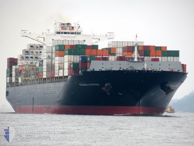
ISTANBUL EXPRESS
Cargo D
Current Trip
| Time Travelled | 3 days |
|---|---|
| Remaining Time | --- |
| Distance Travelled | 1358.41 nm |
| Remaining Distance | 2518.48 nm |
| AVG Speed | 14.9 Knots |
| MAX Speed | 19 Knots |
| AVG Wind | 13.1 knots |
| MAX Wind | 26.8 knots |
| MIN Temp | 11.2°C / 52.16°F |
| MAX Temp | 17.8°C / 64.04°F |
| Dybgang | 12.9 m |
| Position Modtaget | 2 d siden |
Current Position
| Longitude | -8.21955° |
|---|---|
| Latitude | 49.30699° |
| Status | Under way using engine |
| Fart | 16.1 Knots |
| Kurs | 258.6° |
| Område | Celtic Sea |
| Station | T-AIS |
| Position Modtaget | 2 d siden |
Info
Information
The current position of ISTANBUL EXPRESS is in Celtic Sea with coordinates 49.30699° / -8.21955° as reported on 2024-05-20 17:44 by AIS to our vessel tracker app. The vessel's current speed is 16.1 Knots and is heading at the port of BOCA CHIKA. The estimated time of arrival as calculated by MyShipTracking vessel tracking app is 2024-05-30 11:00 LT
The vessel ISTANBUL EXPRESS (IMO: 9723277, MMSI: 256763000) is a Cargo D It's sailing under the flag of [MT] Malta.
In this page you can find informations about the vessels current position, last detected port calls, and current voyage information. If the vessels is not in coverage by AIS you will find the latest position.
The current position of ISTANBUL EXPRESS is detected by our AIS receivers and we are not responsible for the reliability of the data. The last position was recorded while the vessel was in Coverage by the Ais receivers of our vessel tracking app.
The current draught of ISTANBUL EXPRESS as reported by AIS is 12.9 meters
Weather
| Temperature | 17.6°C / 63.68°F |
|---|---|
| Wind Speed | 14 knots |
| Direction | 245° WSW |
| Pressure | 1001.5 hPa |
| Humidity | 94.6 % |
| Cloud Coverage | 100 % |
Featured Company
Last Port Calls
| Port | Arrival | Departure | Time In Port |
|---|---|---|---|
| 2024-05-18 23:09 | 2024-05-19 22:20 | 23 h | |
| 2024-05-15 19:26 | 2024-05-16 20:53 | 1 d | |
| 2024-05-12 19:55 | 2024-05-13 23:27 | 1 d | |
| 2024-05-10 20:34 | 2024-05-11 12:02 | 15 h | |
| 2024-05-08 08:36 | 2024-05-10 10:07 | 2 d | |
| 2024-04-27 11:05 | 2024-04-28 23:28 | 1 d | |
| 2024-04-24 13:13 | 2024-04-25 22:52 | 1 d | |
| 2024-04-20 04:20 | 2024-04-20 10:40 | 6 h | |
| 2024-04-19 11:26 | 2024-04-20 03:52 | 16 h | |
| 2024-04-16 03:24 | 2024-04-17 07:29 | 1 d |
Most Visited Ports (Last year)
| Port | Arrivals | |
|---|---|---|
| 6 | ||
| 5 | ||
| 4 | ||
| 4 | ||
| 4 | ||
| 4 |
Last Trips
| Origin | Departure | Destination | Arrival | Distance | |
|---|---|---|---|---|---|
| 2024-05-16 20:53 | 2024-05-18 23:09 | 277.23 nm | |||
| 2024-05-13 23:27 | 2024-05-15 19:26 | 412.25 nm | |||
| 2024-05-11 12:02 | 2024-05-12 19:55 | 413.23 nm | |||
| 2024-05-10 10:07 | 2024-05-10 20:34 | 149.10 nm | |||
| 2024-04-28 23:28 | 2024-05-08 08:36 | 4043.97 nm | |||
| 2024-04-25 22:52 | 2024-04-27 11:05 | 618.55 nm | |||
| 2024-04-20 10:40 | 2024-04-24 13:13 | 1100.72 nm | |||
| 2024-04-20 03:52 | 2024-04-20 04:20 | 0.16 nm | |||
| 2024-04-17 07:29 | 2024-04-19 11:26 | 680.71 nm | |||
| 2024-04-12 23:45 | 2024-04-16 03:24 | 1349.38 nm |
Events
| Tid | Hændelsen | Detaljer | Position / Dest | Info |
|---|---|---|---|---|
| 2024-05-20 17:48 | Status er ændret | Default Under way using engine |
49.30333 / -8.24167
DOCAU
|
Fart: 16.1 kn Kurs: 258.6° |
| 2024-05-20 17:44 | Udenfor Dækning |
49.30699 / -8.21955
Celtic Sea
DOCAU
|
Fart: 16.1 kn Kurs: 258.6° |
|
| 2024-05-20 14:05 | Status er ændret | Under way using engine Default |
49.45903 / -6.78610
DOCAU
|
Fart: 15.8 kn Kurs: 263° |
| 2024-05-20 13:55 | Indenfor Dækning |
49.45805 / -6.79817
Celtic Sea
DOCAU
|
Fart: 15.7 kn Kurs: 262.9° |
|
| 2024-05-20 13:10 | Status er ændret | Default Under way using engine |
49.48933 / -6.42694
DOCAU
|
Fart: 15.1 kn Kurs: 261.3° |
| 2024-05-20 13:02 | Udenfor Dækning |
49.49430 / -6.37778
Celtic Sea
DOCAU
|
Fart: 15.1 kn Kurs: 261.3° |
|
| 2024-05-20 10:25 | Ændre havområde | United Kingdom part of the Celtic Sea United Kingdom part of the English Channel |
49.56220 / -5.33453
Celtic Sea
DOCAU
|
Fart: 16.2 kn Kurs: 266.5° |
| 2024-05-20 09:50 | Status er ændret | Under way using engine Default |
49.59669 / -5.09399
DOCAU
|
Fart: 16.4 kn Kurs: 257° |
| 2024-05-20 09:43 | Status er ændret | Default Under way using engine |
49.60452 / -5.04416
DOCAU
|
Fart: 16.4 kn Kurs: 256.2° |
| 2024-05-20 08:48 | Status er ændret | Under way using engine Default |
49.66611 / -4.67289
DOCAU
|
Fart: 16.5 kn Kurs: 256° |