
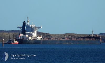
IOANNIS
Cargo
Current Trip
| Time Travelled | 9 days |
|---|---|
| Remaining Time | --- |
| Distance Travelled | 2589.90 nm |
| Remaining Distance | --- |
| AVG Speed | 12 Knots |
| MAX Speed | 14.9 Knots |
| AVG Wind | 10.8 knots |
| MAX Wind | 24.8 knots |
| MIN Temp | 15.8°C / 60.44°F |
| MAX Temp | 30.6°C / 87.08°F |
| Dybgang | 9.4 m |
| Position Modtaget | 3 d siden |
Current Position
| Longitude | 119.83280° |
|---|---|
| Latitude | 14.54531° |
| Status | Under way using engine |
| Fart | 12.4 Knots |
| Kurs | 172.3° |
| Område | South China Sea |
| Station | T-AIS |
| Position Modtaget | 3 d siden |
Info
Information
The current position of IOANNIS is in South China Sea with coordinates 14.54531° / 119.83280° as reported on 2024-06-03 22:34 by AIS to our vessel tracker app. The vessel's current speed is 12.4 Knots and is heading at the port of WHYALLA. The estimated time of arrival as calculated by MyShipTracking vessel tracking app is 2024-06-18 08:00 LT
The vessel IOANNIS (IMO: 9696096, MMSI: 311000131) is a Cargo It's sailing under the flag of [BS] Bahamas.
In this page you can find informations about the vessels current position, last detected port calls, and current voyage information. If the vessels is not in coverage by AIS you will find the latest position.
The current position of IOANNIS is detected by our AIS receivers and we are not responsible for the reliability of the data. The last position was recorded while the vessel was in Coverage by the Ais receivers of our vessel tracking app.
The current draught of IOANNIS as reported by AIS is 9.4 meters
Weather
| Temperature | 27.8°C / 82.04°F |
|---|---|
| Wind Speed | 1 knots |
| Direction | 72° ENE |
| Pressure | 1011.3 hPa |
| Humidity | 74.3 % |
| Cloud Coverage | 100 % |
Featured Company
Last Port Calls
| Port | Arrival | Departure | Time In Port |
|---|---|---|---|
| 2024-05-26 11:24 | 2024-05-29 08:25 | 2 d | |
| 2024-04-29 06:36 | 2024-04-29 15:51 | 9 h | |
| 2024-04-11 23:38 | 2024-04-14 12:30 | 2 d |
Most Visited Ports (Last year)
| Port | Arrivals | |
|---|---|---|
| 2 | ||
| 1 | ||
| 1 | ||
| 1 | ||
| 1 | ||
| 1 |
Last Trips
| Origin | Departure | Destination | Arrival | Distance | |
|---|---|---|---|---|---|
| 2024-04-29 15:51 | 2024-05-26 11:24 | 6076.95 nm | |||
| 2024-04-14 12:30 | 2024-04-29 06:36 | 3919.55 nm | |||
| 2024-03-05 17:52 | 2024-04-11 23:38 | 8402.71 nm |
Events
| Tid | Hændelsen | Detaljer | Position / Dest | Info |
|---|---|---|---|---|
| 2024-06-03 22:34 | Status er ændret | Default Under way using engine |
14.54295 / 119.83315
WHYALLA
|
Fart: 12.4 kn Kurs: 172.3° |
| 2024-06-03 22:34 | Udenfor Dækning |
14.54531 / 119.83280
South China Sea
WHYALLA
|
Fart: 12.4 kn Kurs: 172.3° |
|
| 2024-06-03 21:50 | Status er ændret | Under way using engine Default |
14.69390 / 119.81203
WHYALLA
|
Fart: 12.4 kn Kurs: 176° |
| 2024-06-03 21:41 | Status er ændret | Default Under way using engine |
14.72189 / 119.80576
WHYALLA
|
Fart: 12.5 kn Kurs: 172.2° |
| 2024-06-03 21:32 | Ændre havområde | Philippines part of the South China Sea Chinese part of the Yellow Sea |
14.75507 / 119.80117
South China Sea
WHYALLA
|
Fart: 12.7 kn Kurs: 172.4° |
| 2024-06-03 21:32 | Status er ændret | Under way using engine Default |
14.75507 / 119.80117
WHYALLA
|
Fart: 12.8 kn Kurs: 173° |
| 2024-06-03 21:20 | Indenfor Dækning |
14.75507 / 119.80117
South China Sea
WHYALLA
|
Fart: 12.7 kn Kurs: 172.4° |
|
| 2024-05-30 04:50 | Status er ændret | Default Under way using engine |
35.97908 / 123.87104
WHYALLA
|
Fart: 12.7 kn Kurs: 170.5° |
| 2024-05-30 04:44 | Udenfor Dækning |
35.99722 / 123.86750
Yellow Sea
WHYALLA
|
Fart: 12.7 kn Kurs: 170.5° |
|
| 2024-05-30 04:37 | Dybgangen er ændret | 9.4 18.1 |
36.02543 / 123.86185
WHYALLA
|
Fart: 12.5 kn Kurs: 170.7° |