
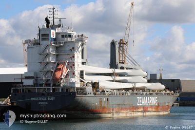
INDUSTRIAL RUBY
General Cargo
Current Trip
| Trip Time | 1 day |
|---|---|
| Trip Distance | 40.44 nm |
| AVG Speed | 8.6 Knots |
| MAX Speed | 15.2 Knots |
| Dybgang | 6 m |
| AVG Wind | 3 knots |
| MAX Wind | 9.4 knots |
| MIN Temp | 7.2°C / 44.96°F |
| MAX Temp | 10.2°C / 50.36°F |
| Position Modtaget | 18 h, 46 m siden |
Current Position
| Longitude | --- |
|---|---|
| Latitude | --- |
| Status | Under way using engine |
| Fart | 2.3 Knots |
| Kurs | 36° |
| Område | Tyrrhenian Sea |
| Station | T-AIS |
| Position Modtaget | 18 h, 46 m siden |
Info
Information
The current position of INDUSTRIAL RUBY is in Tyrrhenian Sea with coordinates 44.03105° / 10.04222° as reported on 2025-02-17 05:28 by AIS to our vessel tracker app. The vessel's current speed is 2.3 Knots and is currently inside the port of MARINA DI CARRARA.
The vessel INDUSTRIAL RUBY (IMO: 9277292, MMSI: 636092314) is a General Cargo that was built in 2005 ( 20 år gamle ). It's sailing under the flag of [LR] Liberia.
In this page you can find informations about the vessels current position, last detected port calls, and current voyage information. If the vessels is not in coverage by AIS you will find the latest position.
The current position of INDUSTRIAL RUBY is detected by our AIS receivers and we are not responsible for the reliability of the data. The last position was recorded while the vessel was in Coverage by the Ais receivers of our vessel tracking app.
The current draught of INDUSTRIAL RUBY as reported by AIS is 6 meters
Weather
| Temperature | 8.9°C / 48.02°F |
|---|---|
| Wind Speed | 2 knots |
| Direction | 118° ESE |
| Pressure | 1018.6 hPa |
| Humidity | 66 % |
| Cloud Coverage | 96 % |
Featured Company
Last Port Calls
| Port | Arrival | Departure | Time In Port |
|---|---|---|---|
| 2025-02-17 05:28 | |||
| 2025-02-10 15:01 | 2025-02-15 19:42 | 5 d | |
| 2025-02-07 08:34 | 2025-02-07 21:18 | 12 h | |
| 2025-01-31 08:58 | 2025-02-03 08:51 | 2 d | |
| 2025-01-31 08:16 | 2025-01-31 08:26 | 9 m | |
| 2025-01-25 08:42 | 2025-01-30 17:28 | 5 d | |
| 2025-01-16 22:15 | 2025-01-17 07:42 | 9 h | |
| 2025-01-04 09:49 | 2025-01-07 02:28 | 2 d | |
| 2024-12-29 20:38 | 2025-01-03 11:43 | 4 d | |
| 2024-12-29 19:52 | 2024-12-29 20:01 | 8 m |
Most Visited Ports (Last year)
| Port | Arrivals | |
|---|---|---|
| 4 | ||
| 3 | ||
| 2 | ||
| 2 | ||
| 2 | ||
| 2 |
Last Trips
| Origin | Departure | Destination | Arrival | Distance | |
|---|---|---|---|---|---|
| 2025-02-15 20:42 | 2025-02-17 06:28 | 40.44 nm | |||
| 2025-02-07 22:18 | 2025-02-10 16:01 | 875.67 nm | |||
| 2025-02-03 08:51 | 2025-02-07 09:34 | 1215.45 nm | |||
| 2025-01-31 08:26 | 2025-01-31 08:58 | 3.61 nm | |||
| 2025-01-30 17:28 | 2025-01-31 08:16 | 178.65 nm | |||
| 2025-01-17 03:42 | 2025-01-25 08:42 | 2233.11 nm | |||
| 2025-01-07 02:28 | 2025-01-16 18:15 | 2883.30 nm | |||
| 2025-01-03 11:43 | 2025-01-04 09:49 | 265.19 nm | |||
| 2024-12-29 20:01 | 2024-12-29 20:38 | 3.46 nm | |||
| 2024-12-29 02:35 | 2024-12-29 19:52 | 209.72 nm |
Events
| Tid | Hændelsen | Detaljer | Position / Dest | Info |
|---|---|---|---|---|
| 2025-02-17 05:36 | STOP Sejllads |
44.03256 / 10.04410
[IT] MARINA DI CARRARA
|
Fart: 0.3 kn Kurs: 28° |
|
| 2025-02-17 05:29 | Status er ændret | Default Under way using engine |
44.03164 / 10.04289
[IT] MARINA DI CARRARA
|
Fart: 2.3 kn Kurs: 36° |
| 2025-02-17 05:28 | Status er ændret | Under way using engine Default |
44.03105 / 10.04222
[IT] MARINA DI CARRARA
|
Fart: 4.2 kn Kurs: 333° |
| 2025-02-17 05:28 | Udenfor Dækning |
44.03105 / 10.04222
Tyrrhenian Sea
[IT] MARINA DI CARRARA
|
Fart: 2.3 kn Kurs: 38.4° |
|
| 2025-02-17 05:28 | Skibe i havn |
|
44.03105 / 10.04222
[IT] MARINA DI CARRARA
|
Fart: 4.2 kn Kurs: 333° |
| 2025-02-17 05:20 | Status er ændret | Default Under way using engine |
44.02618 / 10.04369
IT MDC
|
Fart: 6 kn Kurs: 19.2° |
| 2025-02-17 04:54 | START Sejllads | 2.7 nm, South West of MARINA DI CARRARA |
43.99269 / 10.01041
IT MDC
|
Fart: 3.1 kn Kurs: 31° |
| 2025-02-17 04:51 | Status er ændret | Under way using engine At anchor |
43.99114 / 10.01059
IT MDC
|
Fart: 0.3 kn Kurs: 351° |
| 2025-02-16 23:43 | Status er ændret | At anchor Default |
43.99025 / 10.00958
IT MDC
|
Fart: Kurs: 65° |
| 2025-02-16 23:40 | Status er ændret | Default At anchor |
43.99021 / 10.00956
IT MDC
|
Fart: Kurs: 65° |