
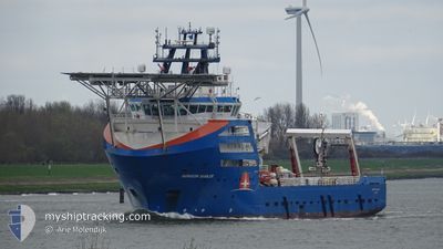
NORTH SEA ENABLER
Offshore Supply Ship
Current Trip
MORAY WEST OWF
| Time Travelled | 16 days |
|---|---|
| Remaining Time | --- |
| Distance Travelled | 198.93 nm |
| Remaining Distance | --- |
| AVG Speed | 9.7 Knots |
| MAX Speed | 11 Knots |
| AVG Wind | 19.8 knots |
| MAX Wind | 33.3 knots |
| MIN Temp | 7.2°C / 44.96°F |
| MAX Temp | 12.6°C / 54.68°F |
| Dybgang | 5.9 m |
| Position Modtaget | 15 d siden |
Current Position
| Longitude | -2.52644° |
|---|---|
| Latitude | 57.94492° |
| Status | Under way using engine |
| Fart | 9.6 Knots |
| Kurs | 281.4° |
| Område | North Sea |
| Station | T-AIS |
| Position Modtaget | 15 d siden |
Info
Information
The current position of NORTH SEA ENABLER is in North Sea with coordinates 57.94492° / -2.52644° as reported on 2024-04-13 19:55 by AIS to our vessel tracker app. The vessel's current speed is 9.6 Knots
The vessel NORTH SEA ENABLER (IMO: 9440203, MMSI: 314627000) is a Offshore Supply Ship that was built in 2010 ( 14 år gamle ). It's sailing under the flag of [BB] Barbados.
In this page you can find informations about the vessels current position, last detected port calls, and current voyage information. If the vessels is not in coverage by AIS you will find the latest position.
The current position of NORTH SEA ENABLER is detected by our AIS receivers and we are not responsible for the reliability of the data. The last position was recorded while the vessel was in Coverage by the Ais receivers of our vessel tracking app.
The current draught of NORTH SEA ENABLER as reported by AIS is 5.9 meters
Weather
| Temperature | 7.3°C / 45.14°F |
|---|---|
| Wind Speed | 28 knots |
| Direction | 265° W |
| Pressure | 1005.5 hPa |
| Humidity | 74.8 % |
| Cloud Coverage | 21 % |
Featured Company
Last Port Calls
| Port | Arrival | Departure | Time In Port |
|---|---|---|---|
| 2024-03-14 14:19 | 2024-04-12 12:46 | 28 d | |
| 2024-03-02 12:36 | 2024-03-11 07:56 | 8 d | |
| 2024-03-01 06:15 | 2024-03-01 13:10 | 6 h | |
| 2024-02-22 22:55 | 2024-02-22 23:57 | 1 h | |
| 2024-02-21 06:28 | 2024-02-21 11:35 | 5 h | |
| 2024-02-11 08:33 | 2024-02-13 00:24 | 1 d | |
| 2024-02-03 19:35 | 2024-02-10 02:55 | 6 d | |
| 2024-02-01 11:58 |
Last Trips
| Origin | Departure | Destination | Arrival | Distance | |
|---|---|---|---|---|---|
| 2024-03-11 07:56 | 2024-03-14 14:19 | 358.29 nm | |||
| 2024-03-01 13:10 | 2024-03-02 12:36 | 248.39 nm | |||
| 2024-02-22 23:57 | 2024-03-01 06:15 | 97.21 nm | |||
| 2024-02-21 11:35 | 2024-02-22 22:55 | 88.61 nm | |||
| 2024-02-13 00:24 | 2024-02-21 06:28 | 91.81 nm | |||
| 2024-02-10 02:55 | 2024-02-11 08:33 | 255.27 nm | |||
| 2024-02-01 12:58 | 2024-02-03 19:35 | 521.66 nm |
Events
| Tid | Hændelsen | Detaljer | Position / Dest | Info |
|---|