

HIMMEL
General Cargo

Current Trip
| Time Travelled | 5 days |
|---|---|
| Remaining Time | --- |
| Distance Travelled | 1066.55 nm |
| Remaining Distance | --- |
| AVG Speed | 8.5 Knots |
| MAX Speed | 10.2 Knots |
| AVG Wind | 10.2 knots |
| MAX Wind | 33 knots |
| MIN Temp | 11.3°C / 52.34°F |
| MAX Temp | 23.1°C / 73.58°F |
| Dybgang | 4.1 m |
| Position Modtaget | 4 m siden |
Current Position
| Longitude | --- |
|---|---|
| Latitude | --- |
| Status | At anchor |
| Fart | |
| Kurs | 76° |
| Område | Sea of Marmara |
| Station | T-AIS |
| Position Modtaget | 4 m siden |
Information
The current position of HIMMEL is in Sea of Marmara with coordinates 40.74717° / 29.88065° as reported on 2025-03-28 01:37 by AIS to our vessel tracker app. The vessel's current speed is 0 Knots
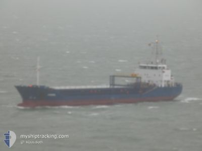
The vessel HIMMEL (IMO: 9518414, MMSI: 255802860) is a General Cargo that was built in 2010 ( 15 år gamle ). It's sailing under the flag of [PT] Portugal.
In this page you can find informations about the vessels current position, last detected port calls, and current voyage information. If the vessels is not in coverage by AIS you will find the latest position.
The current position of HIMMEL is detected by our AIS receivers and we are not responsible for the reliability of the data. The last position was recorded while the vessel was in Coverage by the Ais receivers of our vessel tracking app.
The current draught of HIMMEL as reported by AIS is 4.1 meters
Weather
| Temperature | 17.5°C / 63.5°F |
|---|---|
| Wind Speed | 3 knots |
| Direction | 116° ESE |
| Pressure | 1004.2 hPa |
| Humidity | 47.7 % |
| Cloud Coverage | 100 % |


Featured Company
Last Port Calls
| Port | Arrival | Departure | Time In Port |
|---|---|---|---|
| 2025-03-20 07:23 | 2025-03-22 15:53 | 2 d | |
| 2025-03-18 18:01 | 2025-03-19 06:37 | 12 h | |
| 2025-03-14 11:27 | 2025-03-15 15:25 | 1 d | |
| 2025-03-08 13:38 | 2025-03-12 18:12 | 4 d | |
| 2025-02-27 16:04 | 2025-03-01 20:37 | 2 d | |
| 2025-02-18 12:19 | 2025-02-19 10:22 | 22 h | |
| 2025-02-08 07:36 | 2025-02-08 16:56 | 9 h | |
| 2025-01-29 00:43 | 2025-02-01 19:01 | 3 d | |
| 2025-01-25 18:23 | 2025-01-28 02:32 | 2 d | |
| 2025-01-25 16:52 | 2025-01-25 17:08 | 16 m |
Last Trips
| Origin | Departure | Destination | Arrival | Distance | |
|---|---|---|---|---|---|
| 2025-03-19 06:37 | 2025-03-20 07:23 | 190.06 nm | |||
| 2025-03-15 15:25 | 2025-03-18 18:01 | 655.32 nm | |||
| 2025-03-12 18:12 | 2025-03-14 11:27 | 386.70 nm | |||
| 2025-03-01 20:37 | 2025-03-08 13:38 | 1306.32 nm | |||
| 2025-02-19 10:22 | 2025-02-27 16:04 | 292.23 nm | |||
| 2025-02-08 16:56 | 2025-02-18 12:19 | 1816.68 nm | |||
| 2025-02-01 19:01 | 2025-02-08 07:36 | 1365.31 nm | |||
| 2025-01-28 02:32 | 2025-01-29 00:43 | 79.03 nm | |||
| 2025-01-25 17:08 | 2025-01-25 18:23 | 7.18 nm | |||
| 2025-01-21 09:15 | 2025-01-25 16:52 | 788.06 nm |
Events
| Tid | Hændelsen | Detaljer | Position / Dest | Info |
|---|---|---|---|---|
| 2025-03-28 00:07 | Status er ændret | At anchor Default |
40.74757 / 29.88063
DERINCE
|
Fart: 0.1 kn Kurs: 104° |
| 2025-03-28 00:01 | Status er ændret | Default At anchor |
40.74753 / 29.88057
DERINCE
|
Fart: 0.1 kn Kurs: 100° |
| 2025-03-27 21:07 | Status er ændret | At anchor Default |
40.74732 / 29.88072
DERINCE
|
Fart: Kurs: 91° |
| 2025-03-27 21:01 | Status er ændret | Default At anchor |
40.74733 / 29.88062
DERINCE
|
Fart: Kurs: 91° |
| 2025-03-27 18:01 | STOP Sejllads | 1.5 nm, North of AUTOPORT |
40.74782 / 29.88108
DERINCE
|
Fart: 0.2 kn Kurs: 140° |
| 2025-03-27 17:57 | Status er ændret | At anchor Under way using engine |
40.74790 / 29.88098
DERINCE
|
Fart: 0.7 kn Kurs: 149° |
| 2025-03-27 06:12 | Status er ændret | Under way using engine Default |
40.70467 / 27.66363
DERINCE
|
Fart: 8.5 kn Kurs: 84° |
| 2025-03-27 06:03 | Indenfor Dækning |
40.70485 / 27.66575
Sea of Marmara
DERINCE
|
Fart: 8.4 kn Kurs: 83° |
|
| 2025-03-27 00:11 | Status er ændret | Default Under way using engine |
40.31977 / 26.61857
DERINCE
|
Fart: 8.5 kn Kurs: 40° |
| 2025-03-27 00:09 | Udenfor Dækning |
40.31538 / 26.61343
Sea of Marmara
DERINCE
|
Fart: 8.5 kn Kurs: 40° |