
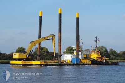
HELENE
Dredging or underwater ops
Current Trip
| Trip Time | 17 days |
|---|---|
| Trip Distance | 72.13 nm |
| AVG Speed | 5.3 Knots |
| MAX Speed | 7.4 Knots |
| Dybgang | 1.4 m |
| AVG Wind | 12.7 knots |
| MAX Wind | 14 knots |
| MIN Temp | 1.4°C / 34.52°F |
| MAX Temp | 22.7°C / 72.86°F |
| Position Modtaget | 5 m siden |
Current Position
| Longitude | 10.17724° |
|---|---|
| Latitude | 54.32924° |
| Status | Not under command |
| Fart | |
| Kurs | --- |
| Område | North Sea |
| Station | T-AIS |
| Position Modtaget | 5 m siden |
Info
Information
The current position of HELENE is in North Sea with coordinates 54.32924° / 10.17724° as reported on 2024-05-06 19:14 by AIS to our vessel tracker app. The vessel's current speed is 0 Knots and is currently inside the port of KIEL.
The vessel HELENE (MMSI: 211526930) is a Dredging or underwater ops It's sailing under the flag of [DE] Germany.
In this page you can find informations about the vessels current position, last detected port calls, and current voyage information. If the vessels is not in coverage by AIS you will find the latest position.
The current position of HELENE is detected by our AIS receivers and we are not responsible for the reliability of the data. The last position was recorded while the vessel was in Coverage by the Ais receivers of our vessel tracking app.
The current draught of HELENE as reported by AIS is 1.4 meters
Weather
| Temperature | 9.7°C / 49.46°F |
|---|---|
| Wind Speed | 4 knots |
| Direction | 33° NNE |
| Pressure | 1011.3 hPa |
| Humidity | 90.7 % |
| Cloud Coverage | 38 % |
Featured Company
Most Visited Ports (Last year)
| Port | Arrivals | |
|---|---|---|
| 13 | ||
| 2 | ||
| 1 | ||
| 1 |
Events
| Tid | Hændelsen | Detaljer | Position / Dest | Info |
|---|---|---|---|---|
| 2024-05-02 15:37 | STOP Sejllads |
54.32856 / 10.17986
[DE] KIEL
|
Fart: Kurs: 511° |
|
| 2024-05-02 15:03 | Skibe i havn |
|
54.36406 / 10.15128
[DE] KIEL
|
Fart: 5.5 kn Kurs: 104.5° |
| 2024-05-02 15:00 | START Sejllads | 1.36 nm, South West of STICKENHΟRN SPORT |
54.36532 / 10.14364
LNG CONSTR SITE
|
Fart: 3.8 kn Kurs: 106.3° |
| 2024-05-02 14:26 | STOP Sejllads | 1.4 nm, South West of STICKENHΟRN SPORT |
54.36587 / 10.14049
LNG CONSTR SITE
|
Fart: 0.2 kn Kurs: 511° |
| 2024-05-02 14:19 | Status er ændret | Not under command Under way using engine |
54.36747 / 10.12880
LNG CONSTR SITE
|
Fart: 18.5 kn Kurs: 104.5° |
| 2024-05-02 14:18 | Status er ændret | Under way using engine Not under command |
54.36754 / 10.12832
LNG CONSTR SITE
|
Fart: 5.7 kn Kurs: 104.5° |
| 2024-05-02 13:09 | START Sejllads | 7.02 nm, West of KIEL |
54.34144 / 9.96028
LNG CONSTR SITE
|
Fart: 5.1 kn Kurs: 81.1° |
| 2024-05-02 12:17 | STOP Sejllads | 7.14 nm, West of KIEL |
54.34098 / 9.95710
LNG CONSTR SITE
|
Fart: 0.2 kn Kurs: 511° |
| 2024-05-02 03:54 | START Sejllads | 0.14 nm, South of BRUNSBUETTEL |
53.90078 / 9.15958
LNG CONSTR SITE
|
Fart: 5.3 kn Kurs: 23.2° |
| 2024-05-01 13:12 | STOP Sejllads | 0.24 nm, South of BRUNSBUETTEL |
53.89912 / 9.15833
LNG CONSTR SITE
|
Fart: 0.2 kn Kurs: 511° |