
HAMMERSHUS
Passenger
Current Trip
| Trip Time | 4 h, 58 mins |
|---|---|
| Trip Distance | 90.35 nm |
| AVG Speed | 17.5 Knots |
| MAX Speed | 19.6 Knots |
| Dybgang | 5.4 m |
| AVG Wind | 10.1 knots |
| MAX Wind | 12.4 knots |
| MIN Temp | 8°C / 46.4°F |
| MAX Temp | 8.8°C / 47.84°F |
| Position Modtaget | 2 m siden |
Current Position
| Longitude | 14.68961° |
|---|---|
| Latitude | 55.09846° |
| Status | Moored |
| Fart | |
| Kurs | 175° |
| Område | Kattegat |
| Station | T-AIS |
| Position Modtaget | 2 m siden |
Info
Information
The current position of HAMMERSHUS is in Kattegat with coordinates 55.09846° / 14.68961° as reported on 2024-04-30 05:02 by AIS to our vessel tracker app. The vessel's current speed is 0 Knots and is currently inside the port of ROENNE.
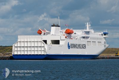
The vessel HAMMERSHUS (IMO: 9812107, MMSI: 219026000) is a Passenger It's sailing under the flag of [DK] Denmark.
In this page you can find informations about the vessels current position, last detected port calls, and current voyage information. If the vessels is not in coverage by AIS you will find the latest position.
The current position of HAMMERSHUS is detected by our AIS receivers and we are not responsible for the reliability of the data. The last position was recorded while the vessel was in Coverage by the Ais receivers of our vessel tracking app.
The current draught of HAMMERSHUS as reported by AIS is 5.4 meters
Weather
| Temperature | 8.3°C / 46.94°F |
|---|---|
| Wind Speed | 13 knots |
| Direction | 76° ENE |
| Pressure | 1024.6 hPa |
| Humidity | 77.5 % |
| Cloud Coverage | 64 % |
Featured Company
Last Port Calls
| Port | Arrival | Departure | Time In Port |
|---|---|---|---|
| 2024-04-30 03:40 | |||
| 2024-04-29 20:09 | 2024-04-29 22:42 | 2 h | |
| 2024-04-29 03:40 | 2024-04-29 15:00 | 11 h | |
| 2024-04-28 20:15 | 2024-04-28 22:25 | 2 h | |
| 2024-04-28 12:50 | 2024-04-28 15:03 | 2 h | |
| 2024-04-28 09:06 | 2024-04-28 10:02 | 56 m | |
| 2024-04-28 03:40 | 2024-04-28 06:01 | 2 h | |
| 2024-04-27 20:13 | 2024-04-27 22:23 | 2 h | |
| 2024-04-27 12:51 | 2024-04-27 14:59 | 2 h | |
| 2024-04-27 09:01 | 2024-04-27 09:56 | 55 m |
Last Trips
| Origin | Departure | Destination | Arrival | Distance | |
|---|---|---|---|---|---|
| 2024-04-30 00:42 | 2024-04-30 05:40 | 90.35 nm | |||
| 2024-04-29 17:00 | 2024-04-29 22:09 | 88.97 nm | |||
| 2024-04-29 00:25 | 2024-04-29 05:40 | 90.09 nm | |||
| 2024-04-28 17:03 | 2024-04-28 22:15 | 90.02 nm | |||
| 2024-04-28 12:02 | 2024-04-28 14:50 | 51.95 nm | |||
| 2024-04-28 08:01 | 2024-04-28 11:06 | 53.15 nm | |||
| 2024-04-28 00:23 | 2024-04-28 05:40 | 90.30 nm | |||
| 2024-04-27 16:59 | 2024-04-27 22:13 | 90.27 nm | |||
| 2024-04-27 11:56 | 2024-04-27 14:51 | 53.73 nm | |||
| 2024-04-27 07:56 | 2024-04-27 11:01 | 52.66 nm |
Events
| Tid | Hændelsen | Detaljer | Position / Dest | Info |
|---|---|---|---|---|
| 2024-04-30 04:10 | ETA er ændret | 2024/04/30 20:30 2024/04/30 04:00 |
55.09847 / 14.68961
[DK] ROENNE
|
Fart: Kurs: 175° |
| 2024-04-30 04:02 | Status er ændret | Moored Under way using engine |
55.09847 / 14.68961
[DK] ROENNE
|
Fart: Kurs: 175° |
| 2024-04-30 04:02 | Destination er ændret | KOGE RONNE |
55.09847 / 14.68960
[DK] ROENNE
|
Fart: Kurs: 175° |
| 2024-04-30 03:45 | STOP Sejllads |
55.09707 / 14.69188
[DK] ROENNE
|
Fart: 0.2 kn Kurs: 79° |
|
| 2024-04-30 03:40 | Skibe i havn |
|
55.09397 / 14.68089
[DK] ROENNE
|
Fart: 11.3 kn Kurs: 65.9° |
| 2024-04-30 02:50 | Ændre havområde | Danish part of the Kattegat Swedish part of the Baltic Sea |
55.13674 / 14.22917
Kattegat
RONNE
|
Fart: 19.6 kn Kurs: 100.2° |
| 2024-04-29 23:56 | Ændre havområde | Swedish part of the Baltic Sea Danish part of the Baltic Sea |
55.29022 / 12.66279
Baltic Sea
RONNE
|
Fart: 17.5 kn Kurs: 110.4° |
| 2024-04-29 23:47 | Ændre havområde | Danish part of the Baltic Sea Danish part of the Kattegat |
55.31759 / 12.60311
Baltic Sea
RONNE
|
Fart: 17.7 kn Kurs: 133.6° |
| 2024-04-29 22:42 | Afsejlet fra sidste havn |
|
55.45776 / 12.21369
RONNE
|
Fart: 9.9 kn Kurs: 81° |
| 2024-04-29 22:39 | START Sejllads |
55.45593 / 12.20048
[DK] KOEGE
|
Fart: 5.6 kn Kurs: 77° |