

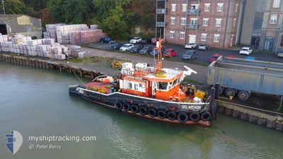
GPS ARCADIA
Tug

Current Trip
MISTLEY
| Time Travelled | 3 days |
|---|---|
| Remaining Time | --- |
| Distance Travelled | 100.78 nm |
| Remaining Distance | --- |
| AVG Speed | 8.6 Knots |
| MAX Speed | 13.3 Knots |
| AVG Wind | 9.7 knots |
| MAX Wind | 14.8 knots |
| MIN Temp | 8.1°C / 46.58°F |
| MAX Temp | 15.9°C / 60.62°F |
| Dybgang | 2.2 m |
| Position Modtaget | 2 d siden |
Current Position
| Longitude | --- |
|---|---|
| Latitude | --- |
| Status | Under way using engine |
| Fart | 0.2 Knots |
| Kurs | --- |
| Område | North Sea |
| Station | T-AIS |
| Position Modtaget | 2 d siden |
Information
The current position of GPS ARCADIA is in North Sea with coordinates 51.49876° / 0.07269° as reported on 2025-03-21 15:19 by AIS to our vessel tracker app. The vessel's current speed is 0.2 Knots
The vessel GPS ARCADIA (MMSI: 235115658) is a Tug It's sailing under the flag of [GB] United Kingdom.
In this page you can find informations about the vessels current position, last detected port calls, and current voyage information. If the vessels is not in coverage by AIS you will find the latest position.
The current position of GPS ARCADIA is detected by our AIS receivers and we are not responsible for the reliability of the data. The last position was recorded while the vessel was in Coverage by the Ais receivers of our vessel tracking app.
The current draught of GPS ARCADIA as reported by AIS is 2.2 meters
Weather
| Temperature | 15.7°C / 60.26°F |
|---|---|
| Wind Speed | 11 knots |
| Direction | 140° SE |
| Pressure | 1004.1 hPa |
| Humidity | 59 % |
| Cloud Coverage | 100 % |


Featured Company
Last Port Calls
| Port | Arrival | Departure | Time In Port |
|---|---|---|---|
| 2025-03-20 02:53 | 2025-03-20 13:02 | 10 h | |
| 2025-03-19 15:34 | 2025-03-19 15:49 | 14 m | |
| 2025-03-17 18:31 | 2025-03-17 19:18 | 46 m | |
| 2025-03-17 16:12 | 2025-03-17 18:00 | 1 h | |
| 2025-03-17 13:55 | 2025-03-17 14:14 | 19 m | |
| 2025-03-17 10:42 | 2025-03-17 11:22 | 40 m | |
| 2025-03-17 06:09 | 2025-03-17 09:54 | 3 h | |
| 2025-03-17 05:23 | 2025-03-17 05:26 | 2 m | |
| 2025-03-14 12:14 | 2025-03-14 12:50 | 36 m | |
| 2025-03-14 11:07 | 2025-03-14 11:18 | 11 m |
Last Trips
| Origin | Departure | Destination | Arrival | Distance | |
|---|---|---|---|---|---|
| 2025-03-19 15:49 | 2025-03-20 02:53 | 57.44 nm | |||
| 2025-03-17 19:18 | 2025-03-19 15:34 | 51.55 nm | |||
| 2025-03-17 18:00 | 2025-03-17 18:31 | 3.73 nm | |||
| 2025-03-17 14:14 | 2025-03-17 16:12 | 17.62 nm | |||
| 2025-03-17 11:22 | 2025-03-17 13:55 | 7.93 nm | |||
| 2025-03-17 09:54 | 2025-03-17 10:42 | 6.06 nm | |||
| 2025-03-17 05:26 | 2025-03-17 06:09 | 3.45 nm | |||
| 2025-03-14 12:50 | 2025-03-17 05:23 | 1.60 nm | |||
| 2025-03-14 11:18 | 2025-03-14 12:14 | 5.64 nm | |||
| 2025-03-13 13:59 | 2025-03-14 11:07 | 11.49 nm |
Events
| Tid | Hændelsen | Detaljer | Position / Dest | Info |
|---|---|---|---|---|
| 2025-03-21 15:19 | Udenfor Dækning |
51.49876 / .07270
North Sea
|
Fart: 0.2 kn Kurs: 131.9° |
|
| 2025-03-21 15:15 | STOP Sejllads | 0.24 nm, North East of WOOLWICH |
51.49876 / .07269
MISTLEY
|
Fart: 0.2 kn Kurs: 511° |
| 2025-03-21 14:08 | START Sejllads | 0.71 nm, South East of SOUTH STIFFORD |
51.46508 / .31786
MISTLEY
|
Fart: 10.3 kn Kurs: 325.1° |
| 2025-03-21 13:18 | STOP Sejllads | 0.83 nm, South East of SOUTH STIFFORD |
51.46352 / .31986
MISTLEY
|
Fart: 0.3 kn Kurs: 511° |
| 2025-03-21 10:28 | START Sejllads | 0.63 nm, North West of CHATHAM |
51.41033 / .53284
MISTLEY
|
Fart: 7.5 kn Kurs: 48.6° |
| 2025-03-21 09:12 | STOP Sejllads | 0.64 nm, North West of CHATHAM |
51.40928 / .53034
MISTLEY
|
Fart: 0.2 kn Kurs: 511° |
| 2025-03-21 08:15 | START Sejllads | 0.53 nm, South East of THAMESPORT |
51.42517 / .70093
MISTLEY
|
Fart: 8.8 kn Kurs: 284° |
| 2025-03-20 20:03 | STOP Sejllads | 0.63 nm, South East of THAMESPORT |
51.42443 / .70372
MISTLEY
|
Fart: 0.3 kn Kurs: 511° |
| 2025-03-20 13:02 | Afsejlet fra sidste havn |
|
51.94742 / 1.09235
MISTLEY
|
Fart: 5.8 kn Kurs: 64.3° |
| 2025-03-20 13:01 | START Sejllads |
51.94611 / 1.08828
[GB] MISTLEY
|
Fart: 5.8 kn Kurs: 59° |