

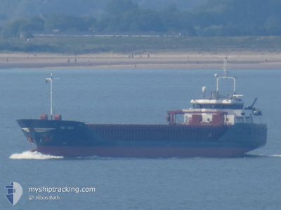
FRI SEA
General Cargo

Current Trip
| Time Travelled | 16 h, 26 mins |
|---|---|
| Remaining Time | 1 day |
| Distance Travelled | 153.07 nm |
| Remaining Distance | 475.01 nm |
| AVG Speed | 11.2 Knots |
| MAX Speed | 13.9 Knots |
| AVG Wind | 14.3 knots |
| MAX Wind | 18 knots |
| MIN Temp | 9.2°C / 48.56°F |
| MAX Temp | 12.8°C / 55.04°F |
| Dybgang | 3.8 m |
| Position Modtaget | 5 h, 27 m siden |
Current Position
| Longitude | --- |
|---|---|
| Latitude | --- |
| Status | Under way using engine |
| Fart | 11.7 Knots |
| Kurs | 201.5° |
| Område | Irish Sea and St. George's Channel |
| Station | T-AIS |
| Position Modtaget | 5 h, 27 m siden |
Information
The current position of FRI SEA is in Irish Sea and St. George's Channel with coordinates 52.86627° / -5.26887° as reported on 2025-03-22 06:19 by AIS to our vessel tracker app. The vessel's current speed is 11.7 Knots and is heading at the port of TERNEUZEN. The estimated time of arrival as calculated by MyShipTracking vessel tracking app is 2025-03-24 03:54 LT
The vessel FRI SEA (IMO: 9229166, MMSI: 311028300) is a General Cargo that was built in 2001 ( 24 år gamle ). It's sailing under the flag of [BS] Bahamas.
In this page you can find informations about the vessels current position, last detected port calls, and current voyage information. If the vessels is not in coverage by AIS you will find the latest position.
The current position of FRI SEA is detected by our AIS receivers and we are not responsible for the reliability of the data. The last position was recorded while the vessel was in Coverage by the Ais receivers of our vessel tracking app.
The current draught of FRI SEA as reported by AIS is 3.8 meters
Weather
| Temperature | 9.7°C / 49.46°F |
|---|---|
| Wind Speed | 9 knots |
| Direction | 149° SSE |
| Pressure | 998.2 hPa |
| Humidity | 90.1 % |
| Cloud Coverage | 100 % |


Featured Company
Last Port Calls
| Port | Arrival | Departure | Time In Port |
|---|---|---|---|
| 2025-03-19 21:51 | 2025-03-21 19:20 | 1 d | |
| 2025-03-17 10:16 | 2025-03-19 19:53 | 2 d | |
| 2025-03-12 14:28 | 2025-03-14 17:17 | 2 d | |
| 2025-03-10 14:16 | 2025-03-12 02:33 | 1 d | |
| 2025-03-06 11:14 | 2025-03-07 03:39 | 16 h | |
| 2025-03-06 09:50 | 2025-03-06 10:18 | 27 m | |
| 2025-02-26 06:23 | 2025-03-04 20:56 | 6 d | |
| 2025-02-21 17:48 | 2025-02-22 14:26 | 20 h | |
| 2025-02-20 22:37 | 2025-02-21 17:39 | 19 h | |
| 2025-02-15 01:20 | 2025-02-17 21:48 | 2 d |
Last Trips
| Origin | Departure | Destination | Arrival | Distance | |
|---|---|---|---|---|---|
| 2025-03-14 18:17 | 2025-03-19 21:51 | 685.69 nm | |||
| 2025-03-14 18:17 | 2025-03-17 10:16 | 663.81 nm | |||
| 2025-03-12 03:33 | 2025-03-12 15:28 | 131.28 nm | |||
| 2025-03-07 04:39 | 2025-03-10 15:16 | 771.53 nm | |||
| 2025-03-06 11:18 | 2025-03-06 12:14 | 9.15 nm | |||
| 2025-03-04 21:56 | 2025-03-06 10:50 | 426.38 nm | |||
| 2025-02-22 15:26 | 2025-02-26 07:23 | 416.44 nm | |||
| 2025-02-21 18:39 | 2025-02-21 18:48 | 0.37 nm | |||
| 2025-02-17 21:48 | 2025-02-20 23:37 | 660.10 nm | |||
| 2025-02-12 03:58 | 2025-02-15 01:20 | 632.54 nm |
Events
| Tid | Hændelsen | Detaljer | Position / Dest | Info |
|---|---|---|---|---|
| 2025-03-22 06:24 | Status er ændret | Default Under way using engine |
52.85097 / -5.27918
FOR ORDER
|
Fart: 11.7 kn Kurs: 201.5° |
| 2025-03-22 06:19 | Udenfor Dækning |
52.86627 / -5.26887
Irish Sea and St. George's Channel
FOR ORDER
|
Fart: 11.7 kn Kurs: 201.5° |
|
| 2025-03-22 06:17 | Status er ændret | Under way using engine Default |
52.87031 / -5.26622
FOR ORDER
|
Fart: 11.5 kn Kurs: 203° |
| 2025-03-22 06:08 | Status er ændret | Default Under way using engine |
52.89838 / -5.24727
FOR ORDER
|
Fart: 11.5 kn Kurs: 202.1° |
| 2025-03-22 06:02 | Status er ændret | Under way using engine Default |
52.91628 / -5.23528
FOR ORDER
|
Fart: 11.5 kn Kurs: 202° |
| 2025-03-22 05:43 | Indenfor Dækning |
52.91628 / -5.23528
Irish Sea and St. George's Channel
FOR ORDER
|
Fart: 11.5 kn Kurs: 202.1° |
|
| 2025-03-22 03:48 | Status er ændret | Default Under way using engine |
53.28898 / -5.00338
FOR ORDER
|
Fart: 10.2 kn Kurs: 199.6° |
| 2025-03-22 03:42 | Udenfor Dækning |
53.30311 / -4.99483
Irish Sea and St. George's Channel
FOR ORDER
|
Fart: 10.2 kn Kurs: 199.6° |
|
| 2025-03-22 03:41 | Status er ændret | Under way using engine Default |
53.30576 / -4.99316
FOR ORDER
|
Fart: 10.1 kn Kurs: 200° |
| 2025-03-22 02:35 | Udenfor Dækning |
53.46388 / -4.85406
Irish Sea and St. George's Channel
FOR ORDER
|
Fart: 9.4 kn Kurs: 218.6° |