
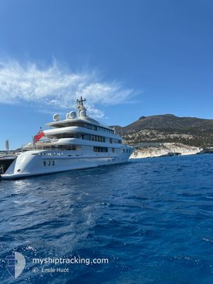
FELIX
Yacht
Current Trip
LAST UPDATE TIME
| Time Travelled | --- |
|---|---|
| Remaining Time | --- |
| Distance Travelled | --- |
| Remaining Distance | --- |
| AVG Speed | --- |
| MAX Speed | --- |
| AVG Wind | --- |
| MAX Wind | --- |
| MIN Temp | --- |
| MAX Temp | --- |
| Dybgang | 3.8 m |
| Position Modtaget | 2 m siden |
Current Position
| Longitude | --- |
|---|---|
| Latitude | --- |
| Status | At anchor |
| Fart | |
| Kurs | 203° |
| Område | South Pacific Ocean |
| Station | T-AIS |
| Position Modtaget | 2 m siden |
Info
Information
The current position of FELIX is in South Pacific Ocean with coordinates -0.89573° / -89.61415° as reported on 2025-03-07 18:57 by AIS to our vessel tracker app. The vessel's current speed is 0 Knots
The vessel FELIX (IMO: 1008217, MMSI: 319369000) is a Yacht that was built in 2006 ( 19 år gamle ). It's sailing under the flag of [KY] Cayman Is.
In this page you can find informations about the vessels current position, last detected port calls, and current voyage information. If the vessels is not in coverage by AIS you will find the latest position.
The current position of FELIX is detected by our AIS receivers and we are not responsible for the reliability of the data. The last position was recorded while the vessel was in Coverage by the Ais receivers of our vessel tracking app.
The current draught of FELIX as reported by AIS is 3.8 meters
Weather
| Temperature | 26.8°C / 80.24°F |
|---|---|
| Wind Speed | 7 knots |
| Direction | 106° ESE |
| Pressure | 1012.4 hPa |
| Humidity | 81.6 % |
| Cloud Coverage | 32 % |
Featured Company
Last Port Calls
| Port | Arrival | Departure | Time In Port |
|---|---|---|---|
| 2025-01-28 15:59 | |||
| 2025-01-10 20:47 | 2025-01-12 16:54 | 1 d | |
| 2025-01-01 10:50 | 2025-01-04 19:32 | 3 d |
Last Trips
| Origin | Departure | Destination | Arrival | Distance | |
|---|---|---|---|---|---|
| 2025-01-04 15:32 | 2025-01-10 16:47 | 132.38 nm | |||
| 2024-12-27 17:58 | 2025-01-01 06:50 | 1176.39 nm |
Events
| Tid | Hændelsen | Detaljer | Position / Dest | Info |
|---|---|---|---|---|
| 2025-03-07 15:14 | Indenfor Dækning |
-.89616 / -89.61437
South Pacific Ocean
|
Fart: Kurs: 148.3° |
|
| 2025-03-07 14:05 | Udenfor Dækning |
-.89632 / -89.61410
South Pacific Ocean
|
Fart: Kurs: 142° |
|
| 2025-03-07 01:47 | Indenfor Dækning |
-.89624 / -89.61424
South Pacific Ocean
|
Fart: Kurs: 305° |
|
| 2025-03-07 00:29 | Udenfor Dækning |
-.89650 / -89.61427
South Pacific Ocean
|
Fart: Kurs: 352° |
|
| 2025-03-05 21:26 | Indenfor Dækning |
-.89645 / -89.61428
South Pacific Ocean
|
Fart: Kurs: 275° |
|
| 2025-03-05 20:14 | Udenfor Dækning |
-.89659 / -89.61421
South Pacific Ocean
|
Fart: Kurs: 304.5° |
|
| 2025-03-05 17:02 | Indenfor Dækning |
-.89631 / -89.61399
South Pacific Ocean
|
Fart: 0.3 kn Kurs: 108.6° |
|
| 2025-03-05 15:59 | Udenfor Dækning |
-.89622 / -89.61380
South Pacific Ocean
|
Fart: Kurs: 193° |
|
| 2025-03-05 14:35 | Indenfor Dækning |
-.89590 / -89.61374
South Pacific Ocean
|
Fart: Kurs: 140.3° |
|
| 2025-03-05 13:05 | Udenfor Dækning |
-.89581 / -89.61375
South Pacific Ocean
|
Fart: Kurs: 336° |