
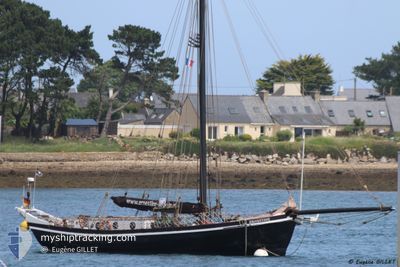
ERNESTINE
Sailing
Current Trip
| Time Travelled | 38 days |
|---|---|
| Remaining Time | --- |
| Distance Travelled | 84.64 nm |
| Remaining Distance | --- |
| AVG Speed | 4.9 Knots |
| MAX Speed | 7.3 Knots |
| AVG Wind | 9.1 knots |
| MAX Wind | 14.1 knots |
| MIN Temp | 13.8°C / 56.84°F |
| MAX Temp | 17°C / 62.6°F |
| Dybgang | 2.3 m |
| Position Modtaget | 2 d siden |
Current Position
| Longitude | 13.10286° |
|---|---|
| Latitude | 54.31480° |
| Status | Under way sailing |
| Fart | 5.2 Knots |
| Kurs | 143.6° |
| Område | Baltic Sea |
| Station | T-AIS |
| Position Modtaget | 2 d siden |
Info
Information
The current position of ERNESTINE is in Baltic Sea with coordinates 54.31480° / 13.10286° as reported on 2024-06-03 10:10 by AIS to our vessel tracker app. The vessel's current speed is 5.2 Knots and is heading at the port of BREST. The estimated time of arrival as calculated by MyShipTracking vessel tracking app is 2024-07-29 18:00 LT
The vessel ERNESTINE (MMSI: 211260310) is a Sailing It's sailing under the flag of [DE] Germany.
In this page you can find informations about the vessels current position, last detected port calls, and current voyage information. If the vessels is not in coverage by AIS you will find the latest position.
The current position of ERNESTINE is detected by our AIS receivers and we are not responsible for the reliability of the data. The last position was recorded while the vessel was in Coverage by the Ais receivers of our vessel tracking app.
The current draught of ERNESTINE as reported by AIS is 2.3 meters
Weather
| Temperature | 16.6°C / 61.88°F |
|---|---|
| Wind Speed | 14 knots |
| Direction | 282° WNW |
| Pressure | 1014.6 hPa |
| Humidity | 69.8 % |
| Cloud Coverage | 12 % |
Featured Company
Last Trips
| Origin | Departure | Destination | Arrival | Distance |
|---|
Events
| Tid | Hændelsen | Detaljer | Position / Dest | Info |
|---|---|---|---|---|
| 2024-06-03 10:10 | Udenfor Dækning |
54.31480 / 13.10286
Baltic Sea
|
Fart: 5.2 kn Kurs: 143.6° |
|
| 2024-06-03 09:50 | Indenfor Dækning |
54.32074 / 13.10828
Baltic Sea
|
Fart: 5.7 kn Kurs: 187.1° |
|
| 2024-06-02 11:22 | Udenfor Dækning |
54.77513 / 12.86035
Baltic Sea
|
Fart: 3.9 kn Kurs: 68.7° |
|
| 2024-06-02 10:45 | Ændre havområde | German part of the Baltic Sea Danish part of the Baltic Sea |
54.77088 / 12.79212
Baltic Sea
|
Fart: 4.4 kn Kurs: 88.9° |
| 2024-06-02 06:44 | START Sejllads | 5.65 nm, South East of STUBBEKOBING |
54.82207 / 12.15068
BREST
|
Fart: 4.4 kn Kurs: 100° |
| 2024-06-02 06:37 | Indenfor Dækning |
54.82193 / 12.14474
Baltic Sea
|
Fart: 0.1 kn Kurs: 511° |
|
| 2024-06-01 16:01 | Udenfor Dækning |
54.82186 / 12.14417
Baltic Sea
|
Fart: 0.3 kn Kurs: 108.2° |
|
| 2024-06-01 15:57 | Status er ændret | At anchor Moored |
54.82187 / 12.14411
BREST
|
Fart: 0.1 kn Kurs: 511° |
| 2024-06-01 15:53 | Status er ændret | Moored At anchor |
54.82189 / 12.14406
BREST
|
Fart: 0.2 kn Kurs: 511° |
| 2024-06-01 15:42 | Status er ændret | At anchor Under way sailing |
54.82189 / 12.14407
BREST
|
Fart: 0.3 kn Kurs: 511° |