

EMPIRE
Container Ship

Current Trip
| Time Travelled | 2 days |
|---|---|
| Remaining Time | 3 h, 6 mins |
| Distance Travelled | 685.69 nm |
| Remaining Distance | 50.01 nm |
| AVG Speed | 10.1 Knots |
| MAX Speed | 17.9 Knots |
| AVG Wind | 7.7 knots |
| MAX Wind | 15 knots |
| MIN Temp | 3.1°C / 37.58°F |
| MAX Temp | 14.2°C / 57.56°F |
| Dybgang | 7.6 m |
| Position Modtaget | 1 m siden |
Current Position
| Longitude | --- |
|---|---|
| Latitude | --- |
| Status | Under way using engine |
| Fart | 13.1 Knots |
| Kurs | 71.2° |
| Område | Gulf of Finland |
| Station | T-AIS |
| Position Modtaget | 1 m siden |
Information
The current position of EMPIRE is in Gulf of Finland with coordinates 59.70169° / 24.25612° as reported on 2025-03-30 05:38 by AIS to our vessel tracker app. The vessel's current speed is 13.1 Knots and is heading at the port of HELSINKI. The estimated time of arrival as calculated by MyShipTracking vessel tracking app is 2025-03-30 11:45 LT
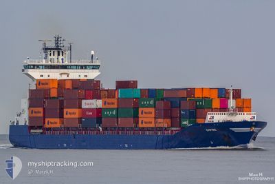
The vessel EMPIRE (IMO: 9387425, MMSI: 245258000) is a Container Ship that was built in 2009 ( 16 år gamle ). It's sailing under the flag of [NL] Netherlands.
In this page you can find informations about the vessels current position, last detected port calls, and current voyage information. If the vessels is not in coverage by AIS you will find the latest position.
The current position of EMPIRE is detected by our AIS receivers and we are not responsible for the reliability of the data. The last position was recorded while the vessel was in Coverage by the Ais receivers of our vessel tracking app.
The current draught of EMPIRE as reported by AIS is 7.6 meters
Weather
| Temperature | 3.2°C / 37.76°F |
|---|---|
| Wind Speed | 8 knots |
| Direction | 194° SSW |
| Pressure | 1008.1 hPa |
| Humidity | 96.4 % |
| Cloud Coverage | 100 % |


Featured Company
Last Port Calls
| Port | Arrival | Departure | Time In Port |
|---|---|---|---|
| 2025-03-26 04:53 | 2025-03-27 15:32 | 1 d | |
| 2025-03-24 01:38 | 2025-03-25 18:05 | 1 d | |
| 2025-03-23 08:35 | 2025-03-23 09:20 | 45 m | |
| 2025-03-20 08:47 | 2025-03-21 12:01 | 1 d | |
| 2025-03-18 22:42 | 2025-03-19 13:17 | 14 h | |
| 2025-03-18 04:49 | 2025-03-18 19:10 | 14 h | |
| 2025-03-16 07:26 | 2025-03-16 21:33 | 14 h | |
| 2025-03-14 15:43 | 2025-03-14 15:48 | 4 m | |
| 2025-03-10 13:42 | 2025-03-13 23:18 | 3 d | |
| 2025-03-06 14:23 | 2025-03-07 18:50 | 1 d |
Last Trips
| Origin | Departure | Destination | Arrival | Distance | |
|---|---|---|---|---|---|
| 2025-03-25 18:05 | 2025-03-26 04:53 | 109.39 nm | |||
| 2025-03-23 09:20 | 2025-03-24 01:38 | 127.69 nm | |||
| 2025-03-21 12:01 | 2025-03-23 08:35 | 651.80 nm | |||
| 2025-03-19 13:17 | 2025-03-20 08:47 | 304.88 nm | |||
| 2025-03-18 19:10 | 2025-03-18 22:42 | 45.12 nm | |||
| 2025-03-16 21:33 | 2025-03-18 04:49 | 434.18 nm | |||
| 2025-03-14 15:48 | 2025-03-16 07:26 | 350.33 nm | |||
| 2025-03-13 23:18 | 2025-03-14 15:43 | 87.19 nm | |||
| 2025-03-07 18:50 | 2025-03-10 13:42 | 745.24 nm | |||
| 2025-03-04 20:14 | 2025-03-06 14:23 | 313.00 nm |
Events
| Tid | Hændelsen | Detaljer | Position / Dest | Info |
|---|---|---|---|---|
| 2025-03-30 03:08 | Ændre havområde | Finnish part of the Gulf of Finland Estonian part of the Gulf of Finland |
59.52987 / 23.22875
Gulf of Finland
FIHEL
|
Fart: 13.5 kn Kurs: 73.5° |
| 2025-03-30 03:02 | Ændre havområde | Estonian part of the Gulf of Finland Estonian part of the Baltic Sea |
59.52338 / 23.18674
Gulf of Finland
FIHEL
|
Fart: 13.4 kn Kurs: 73.3° |
| 2025-03-30 02:50 | Ændre havområde | Estonian part of the Baltic Sea Finnish part of the Baltic Sea |
59.51035 / 23.10431
Baltic Sea
FIHEL
|
Fart: 13.4 kn Kurs: 72.4° |
| 2025-03-30 01:28 | Ændre havområde | Finnish part of the Baltic Sea Estonian part of the Baltic Sea |
59.40442 / 22.54996
Baltic Sea
FIHEL
|
Fart: 13.5 kn Kurs: 48.6° |
| 2025-03-30 00:53 | Fundet i havområde | Estonian part of the Baltic Sea |
59.31901 / 22.35229
Baltic Sea
FIHEL
|
Fart: 13.2 kn Kurs: 50.1° |
| 2025-03-30 00:52 | Status er ændret | Under way using engine Default |
59.31665 / 22.34677
FIHEL
|
Fart: 13.2 kn Kurs: 50° |
| 2025-03-30 00:44 | Indenfor Dækning |
59.31901 / 22.35229
Baltic Sea
FIHEL
|
Fart: 13.2 kn Kurs: 50.1° |
|
| 2025-03-29 13:54 | Status er ændret | Default Under way using engine |
57.43939 / 19.37129
FIHEL
|
Fart: 16.2 kn Kurs: 36.5° |
| 2025-03-29 13:47 | Udenfor Dækning |
57.41632 / 19.33977
Baltic Sea
FIHEL
|
Fart: 16.2 kn Kurs: 36.5° |
|
| 2025-03-29 12:16 | Status er ændret | Under way using engine Default |
57.08092 / 18.88731
FIHEL
|
Fart: 16.5 kn Kurs: 36° |