
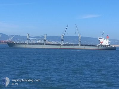
ELM K
General Cargo
Current Trip
| Time Travelled | 11 days |
|---|---|
| Remaining Time | --- |
| Distance Travelled | 1865.68 nm |
| Remaining Distance | --- |
| AVG Speed | 11.5 Knots |
| MAX Speed | 14.6 Knots |
| AVG Wind | 9.7 knots |
| MAX Wind | 17 knots |
| MIN Temp | 25.5°C / 77.9°F |
| MAX Temp | 30.9°C / 87.62°F |
| Dybgang | 6.5 m |
| Position Modtaget | 15 h, 30 m siden |
Current Position
| Longitude | --- |
|---|---|
| Latitude | --- |
| Status | At anchor |
| Fart | 0.2 Knots |
| Kurs | 264° |
| Område | Indian Ocean |
| Station | T-AIS |
| Position Modtaget | 15 h, 30 m siden |
Info
Information
The current position of ELM K is in Indian Ocean with coordinates -21.51893° / 115.06896° as reported on 2024-12-31 13:02 by AIS to our vessel tracker app. The vessel's current speed is 0.2 Knots
The vessel ELM K (IMO: 9614294, MMSI: 373943000) is a General Cargo that was built in 2012 ( 13 år gamle ). It's sailing under the flag of [PA] Panama.
In this page you can find informations about the vessels current position, last detected port calls, and current voyage information. If the vessels is not in coverage by AIS you will find the latest position.
The current position of ELM K is detected by our AIS receivers and we are not responsible for the reliability of the data. The last position was recorded while the vessel was in Coverage by the Ais receivers of our vessel tracking app.
The current draught of ELM K as reported by AIS is 6.5 meters
Weather
| Temperature | 29.9°C / 85.82°F |
|---|---|
| Wind Speed | 10 knots |
| Direction | 5° N |
| Pressure | 1007.8 hPa |
| Humidity | 72.2 % |
| Cloud Coverage | 92 % |
Featured Company
Events
| Tid | Hændelsen | Detaljer | Position / Dest | Info |
|---|---|---|---|---|
| 2024-12-31 13:05 | Status er ændret | Default At anchor |
-21.51895 / 115.06898
AU ONS
|
Fart: 0.2 kn Kurs: 264° |
| 2024-12-31 13:02 | Udenfor Dækning |
-21.51893 / 115.06896
Indian Ocean
|
Fart: 0.2 kn Kurs: 347.9° |
|
| 2024-12-31 12:59 | Status er ændret | At anchor Default |
-21.51900 / 115.06898
AU ONS
|
Fart: 0.1 kn Kurs: 273° |
| 2024-12-31 12:59 | Indenfor Dækning |
-21.51900 / 115.06898
Indian Ocean
|
Fart: 0.1 kn Kurs: 179.2° |
|
| 2024-12-31 11:23 | Status er ændret | Default At anchor |
-21.51932 / 115.06898
AU ONS
|
Fart: 0.2 kn Kurs: 279° |
| 2024-12-31 11:17 | Udenfor Dækning |
-21.51937 / 115.06897
Indian Ocean
|
Fart: 0.2 kn Kurs: 211.6° |
|
| 2024-12-31 11:11 | Status er ændret | At anchor Default |
-21.51938 / 115.06897
AU ONS
|
Fart: 0.1 kn Kurs: 283° |
| 2024-12-31 10:59 | Indenfor Dækning |
-21.51938 / 115.06897
Indian Ocean
|
Fart: 0.1 kn Kurs: 264.2° |
|
| 2024-12-31 09:53 | Status er ændret | Default At anchor |
-21.51937 / 115.06900
AU ONS
|
Fart: 0.1 kn Kurs: 279° |
| 2024-12-31 09:47 | Udenfor Dækning |
-21.51937 / 115.06899
Indian Ocean
|
Fart: 0.1 kn Kurs: 193.8° |