

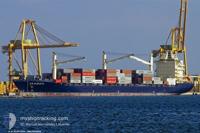
ELIZABETH
Container Ship

Current Trip
| Trip Time | 14 days |
|---|---|
| Trip Distance | 2966.66 nm |
| AVG Speed | 14.1 Knots |
| MAX Speed | 17.9 Knots |
| Dybgang | 11.6 m |
| AVG Wind | 9.5 knots |
| MAX Wind | 20 knots |
| MIN Temp | 18.6°C / 65.48°F |
| MAX Temp | 28.9°C / 84.02°F |
| Position Modtaget | 2025-01-07 19:41 |
Current Position
| Longitude | --- |
|---|---|
| Latitude | --- |
| Status | Under way using engine |
| Fart | 14.1 Knots |
| Kurs | 30.5° |
| Område | North Atlantic Ocean |
| Station | T-AIS |
| Position Modtaget | 2025-01-07 19:41 |
Information
The current position of ELIZABETH is in North Atlantic Ocean with coordinates 13.90370° / -17.71423° as reported on 2025-01-07 19:41 by AIS to our vessel tracker app. The vessel's current speed is 14.1 Knots and is currently inside the port of DAKAR.
The vessel ELIZABETH (IMO: 9246346, MMSI: 636020454) is a Container Ship that was built in 2003 ( 22 år gamle ). It's sailing under the flag of [LR] Liberia.
In this page you can find informations about the vessels current position, last detected port calls, and current voyage information. If the vessels is not in coverage by AIS you will find the latest position.
The current position of ELIZABETH is detected by our AIS receivers and we are not responsible for the reliability of the data. The last position was recorded while the vessel was in Coverage by the Ais receivers of our vessel tracking app.
The current draught of ELIZABETH as reported by AIS is 11.6 meters
Weather
| Temperature | 18.7°C / 65.66°F |
|---|---|
| Wind Speed | 16 knots |
| Direction | 334° NNW |
| Pressure | 1010 hPa |
| Humidity | 86.8 % |
| Cloud Coverage | 86 % |


Featured Company
Last Port Calls
| Port | Arrival | Departure | Time In Port |
|---|---|---|---|
| 2025-02-12 02:35 | |||
| 2025-01-26 04:11 | 2025-01-28 03:19 | 1 d | |
| 2025-01-16 06:22 | 2025-01-17 12:27 | 1 d | |
| 2025-01-08 00:23 | 2025-01-09 12:47 | 1 d | |
| 2024-12-28 05:39 | 2024-12-29 09:59 | 1 d | |
| 2024-12-23 08:55 | 2024-12-24 16:15 | 1 d | |
| 2024-12-10 19:38 | 2024-12-12 09:19 | 1 d | |
| 2024-12-03 17:34 | 2024-12-05 14:38 | 1 d |
Most Visited Ports (Last year)
| Port | Arrivals | |
|---|---|---|
| 19 | ||
| 12 | ||
| 6 | ||
| 1 | ||
| 1 |
Last Trips
| Origin | Departure | Destination | Arrival | Distance | |
|---|---|---|---|---|---|
| 2025-01-28 03:19 | 2025-02-12 02:35 | 2966.66 nm | |||
| 2025-01-17 12:27 | 2025-01-26 04:11 | 2000.25 nm | |||
| 2025-01-09 12:47 | 2025-01-16 06:22 | 1400.42 nm | |||
| 2024-12-29 09:59 | 2025-01-08 00:23 | 1813.74 nm | |||
| 2024-12-24 16:15 | 2024-12-28 05:39 | 1218.48 nm | |||
| 2024-12-12 09:19 | 2024-12-23 08:55 | 2021.43 nm | |||
| 2024-12-05 14:38 | 2024-12-10 19:38 | 1239.53 nm | |||
| 2024-11-22 06:06 | 2024-12-03 17:34 | 1826.88 nm |
Events
| Tid | Hændelsen | Detaljer | Position / Dest | Info |
|---|---|---|---|---|
| 2025-02-12 02:51 | STOP Sejllads |
14.68403 / -17.42621
[SN] DAKAR
|
Fart: 0.2 kn Kurs: 334° |
|
| 2025-02-12 02:35 | Skibe i havn |
|
14.67976 / -17.42372
[SN] DAKAR
|
Fart: 4.4 kn Kurs: 288° |
| 2025-02-12 01:51 | START Sejllads | 2.64 nm, East of GOREE |
14.67527 / -17.35286
ESALG
|
Fart: 5.4 kn Kurs: 276° |
| 2025-02-12 01:27 | STOP Sejllads | 3.02 nm, East of GOREE |
14.67479 / -17.34630
ESALG
|
Fart: 0.3 kn Kurs: 322° |
| 2025-02-12 01:03 | START Sejllads | 3.52 nm, East of GOREE |
14.67188 / -17.33746
ESALG
|
Fart: 3.3 kn Kurs: 291° |
| 2025-02-12 00:19 | STOP Sejllads | 3.79 nm, South West of RUFISQUE |
14.66874 / -17.32751
ESALG
|
Fart: 0.3 kn Kurs: 327° |
| 2025-02-11 23:27 | START Sejllads | 4.3 nm, South of RUFISQUE |
14.64148 / -17.29523
ESALG
|
Fart: 4 kn Kurs: 347° |
| 2025-02-11 16:42 | STOP Sejllads | 4.74 nm, South of RUFISQUE |
14.63401 / -17.29457
ESALG
|
Fart: 0.3 kn Kurs: 358° |
| 2025-02-11 16:23 | START Sejllads | 5.11 nm, South of RUFISQUE |
14.62744 / -17.29372
ESALG
|
Fart: 3.2 kn Kurs: 347° |
| 2025-02-11 15:55 | STOP Sejllads | 4.91 nm, South of RUFISQUE |
14.63086 / -17.29369
ESALG
|
Fart: 0.3 kn Kurs: 344° |