
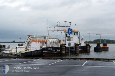
EGHOLM II
Passenger
Current Trip
| Time Travelled | 42 days |
|---|---|
| Remaining Time | --- |
| Distance Travelled | 679.02 nm |
| Remaining Distance | --- |
| AVG Speed | 6.1 Knots |
| MAX Speed | 9.4 Knots |
| AVG Wind | 9.9 knots |
| MAX Wind | 21 knots |
| MIN Temp | 5.3°C / 41.54°F |
| MAX Temp | 24.2°C / 75.56°F |
| Dybgang | 2 m |
| Position Modtaget | 1 m siden |
Current Position
| Longitude | 9.88212° |
|---|---|
| Latitude | 57.05899° |
| Status | Moored |
| Fart | |
| Kurs | 200° |
| Område | Kattegat |
| Station | T-AIS |
| Position Modtaget | 1 m siden |
Info
Information
The current position of EGHOLM II is in Kattegat with coordinates 57.05899° / 9.88212° as reported on 2024-06-29 04:36 by AIS to our vessel tracker app. The vessel's current speed is 0 Knots
The vessel EGHOLM II (MMSI: 219015127) is a Passenger It's sailing under the flag of [DK] Denmark.
In this page you can find informations about the vessels current position, last detected port calls, and current voyage information. If the vessels is not in coverage by AIS you will find the latest position.
The current position of EGHOLM II is detected by our AIS receivers and we are not responsible for the reliability of the data. The last position was recorded while the vessel was in Coverage by the Ais receivers of our vessel tracking app.
The current draught of EGHOLM II as reported by AIS is 2 meters
Weather
| Temperature | 10.5°C / 50.9°F |
|---|---|
| Wind Speed | 8 knots |
| Direction | 217° SW |
| Pressure | 1013.9 hPa |
| Humidity | 91 % |
| Cloud Coverage | --- |
Featured Company
Events
| Tid | Hændelsen | Detaljer | Position / Dest | Info |
|---|---|---|---|---|
| 2024-06-29 04:36 | Status er ændret | Moored Default |
57.05899 / 9.88212
AALBORG
|
Fart: Kurs: 200° |
| 2024-06-29 04:33 | Status er ændret | Default Moored |
57.05900 / 9.88211
AALBORG
|
Fart: Kurs: 200° |
| 2024-06-28 22:07 | STOP Sejllads | 2.55 nm, West of AALBORG |
57.05899 / 9.88211
AALBORG
|
Fart: 0.1 kn Kurs: 198° |
| 2024-06-28 22:05 | START Sejllads | 2.64 nm, West of AALBORG |
57.05986 / 9.87938
AALBORG
|
Fart: 7.9 kn Kurs: 115° |
| 2024-06-28 22:03 | STOP Sejllads | 2.75 nm, West of AALBORG |
57.06099 / 9.87630
AALBORG
|
Fart: 0.1 kn Kurs: 331° |
| 2024-06-28 22:01 | START Sejllads | 2.63 nm, West of AALBORG |
57.06056 / 9.87979
AALBORG
|
Fart: 6.9 kn Kurs: 293.2° |
| 2024-06-28 21:39 | STOP Sejllads | 2.55 nm, West of AALBORG |
57.05899 / 9.88212
AALBORG
|
Fart: 0.1 kn Kurs: 200° |
| 2024-06-28 21:38 | START Sejllads | 2.63 nm, West of AALBORG |
57.05994 / 9.87969
AALBORG
|
Fart: 7.7 kn Kurs: 116.9° |
| 2024-06-28 21:35 | STOP Sejllads | 2.75 nm, West of AALBORG |
57.06100 / 9.87629
AALBORG
|
Fart: 0.1 kn Kurs: 330° |
| 2024-06-28 21:33 | START Sejllads | 2.63 nm, West of AALBORG |
57.06052 / 9.87996
AALBORG
|
Fart: 6.4 kn Kurs: 297.3° |