
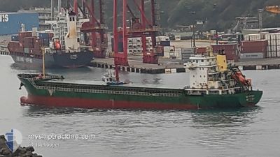
DS VICTORY
General Cargo
Current Trip
| Trip Time | 3 days |
|---|---|
| Trip Distance | 918.41 nm |
| AVG Speed | 9.7 Knots |
| MAX Speed | 11.9 Knots |
| Dybgang | 4.3 m |
| AVG Wind | 15.9 knots |
| MAX Wind | 33 knots |
| MIN Temp | 8.5°C / 47.3°F |
| MAX Temp | 16.1°C / 60.98°F |
| Position Modtaget | 4 d siden |
Current Position
| Longitude | 128.99781° |
|---|---|
| Latitude | 34.79708° |
| Status | Under way using engine |
| Fart | 10.5 Knots |
| Kurs | 224.2° |
| Område | Japan Sea |
| Station | T-AIS |
| Position Modtaget | 4 d siden |
Info
Information
The current position of DS VICTORY is in Japan Sea with coordinates 34.79708° / 128.99781° as reported on 2024-04-29 08:09 by AIS to our vessel tracker app. The vessel's current speed is 10.5 Knots and is currently inside the port of SHIDAO.
The vessel DS VICTORY (IMO: 9550785, MMSI: 312404000) is a General Cargo that was built in 2009 ( 15 år gamle ). It's sailing under the flag of [BZ] Belize.
In this page you can find informations about the vessels current position, last detected port calls, and current voyage information. If the vessels is not in coverage by AIS you will find the latest position.
The current position of DS VICTORY is detected by our AIS receivers and we are not responsible for the reliability of the data. The last position was recorded while the vessel was in Coverage by the Ais receivers of our vessel tracking app.
The current draught of DS VICTORY as reported by AIS is 4.3 meters
Weather
| Temperature | 12.2°C / 53.96°F |
|---|---|
| Wind Speed | 5 knots |
| Direction | 247° WSW |
| Pressure | 1018.4 hPa |
| Humidity | 69.8 % |
| Cloud Coverage | 64 % |
Featured Company
Last Port Calls
| Port | Arrival | Departure | Time In Port |
|---|---|---|---|
| 2024-05-01 02:00 | |||
| 2024-04-20 06:48 | 2024-04-27 05:10 | 6 d | |
| 2024-04-15 04:18 | 2024-04-17 01:19 | 1 d | |
| 2024-04-07 23:15 | 2024-04-12 08:00 | 4 d | |
| 2024-04-04 09:25 | 2024-04-04 23:33 | 14 h | |
| 2024-03-31 07:46 | 2024-04-02 12:39 | 2 d | |
| 2024-03-27 20:40 | 2024-03-29 01:18 | 1 d | |
| 2024-03-24 03:38 | 2024-03-25 13:19 | 1 d | |
| 2024-03-21 05:03 |
Last Trips
| Origin | Departure | Destination | Arrival | Distance | |
|---|---|---|---|---|---|
| 2024-04-27 15:10 | 2024-05-01 10:00 | 918.41 nm | |||
| 2024-04-17 10:19 | 2024-04-20 16:48 | 709.27 nm | |||
| 2024-04-12 17:00 | 2024-04-15 13:18 | 294.75 nm | |||
| 2024-04-05 07:33 | 2024-04-08 08:15 | 590.34 nm | |||
| 2024-04-02 21:39 | 2024-04-04 17:25 | 371.38 nm | |||
| 2024-03-29 09:18 | 2024-03-31 16:46 | 449.45 nm | |||
| 2024-03-25 22:19 | 2024-03-28 04:40 | 451.89 nm | |||
| 2024-03-21 13:03 | 2024-03-24 12:38 | 420.73 nm |
Events
| Tid | Hændelsen | Detaljer | Position / Dest | Info |
|---|---|---|---|---|
| 2024-05-03 06:43 | STOP Sejllads |
36.88186 / 122.43776
[CN] SHIDAO
|
Fart: Kurs: 60° |
|
| 2024-05-03 06:20 | START Sejllads |
36.88483 / 122.44067
[CN] SHIDAO
|
Fart: 4.4 kn Kurs: 332° |
|
| 2024-05-01 02:57 | STOP Sejllads |
36.88799 / 122.43878
[CN] SHIDAO
|
Fart: Kurs: 357° |
|
| 2024-05-01 02:00 | Skibe i havn |
|
36.88437 / 122.45323
[CN] SHIDAO
|
Fart: 6.6 kn Kurs: 328° |
| 2024-04-29 08:11 | Status er ændret | Default Under way using engine |
34.79258 / 128.99243
CN SHD
|
Fart: 10.5 kn Kurs: 224.2° |
| 2024-04-29 08:09 | Udenfor Dækning |
34.79708 / 128.99781
Japan Sea
CN SHD
|
Fart: 10.5 kn Kurs: 224.2° |
|
| 2024-04-29 07:58 | Status er ændret | Under way using engine Default |
34.81952 / 129.02453
CN SHD
|
Fart: 10.4 kn Kurs: 225° |
| 2024-04-29 07:51 | Status er ændret | Default Under way using engine |
34.83435 / 129.04184
CN SHD
|
Fart: 10.4 kn Kurs: 225.2° |
| 2024-04-29 07:44 | Status er ændret | Under way using engine Default |
34.84842 / 129.05845
CN SHD
|
Fart: 10 kn Kurs: 223° |
| 2024-04-29 07:33 | Status er ændret | Default Under way using engine |
34.87092 / 129.08475
CN SHD
|
Fart: 10 kn Kurs: 223.4° |