
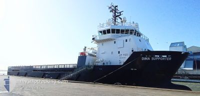
DINA SUPPORTER
Offshore Supply Ship
Current Trip
K6C
| Time Travelled | 5 h, 54 mins |
|---|---|
| Remaining Time | --- |
| Distance Travelled | 9.86 nm |
| Remaining Distance | --- |
| AVG Speed | 9.5 Knots |
| MAX Speed | 10.8 Knots |
| AVG Wind | 14 knots |
| MAX Wind | 14.5 knots |
| MIN Temp | 5.9°C / 42.62°F |
| MAX Temp | 6.1°C / 42.98°F |
| Dybgang | 4.6 m |
| Position Modtaget | 4 h, 40 m siden |
Current Position
| Longitude | --- |
|---|---|
| Latitude | --- |
| Status | Under way using engine |
| Fart | 8.7 Knots |
| Kurs | 314.1° |
| Område | North Sea |
| Station | T-AIS |
| Position Modtaget | 4 h, 40 m siden |
Info
Information
The current position of DINA SUPPORTER is in North Sea with coordinates 52.90713° / 4.57005° as reported on 2025-03-16 20:01 by AIS to our vessel tracker app. The vessel's current speed is 8.7 Knots
The vessel DINA SUPPORTER (IMO: 9402342, MMSI: 255805762) is a Offshore Supply Ship that was built in 2008 ( 17 år gamle ). It's sailing under the flag of [PT] Portugal.
In this page you can find informations about the vessels current position, last detected port calls, and current voyage information. If the vessels is not in coverage by AIS you will find the latest position.
The current position of DINA SUPPORTER is detected by our AIS receivers and we are not responsible for the reliability of the data. The last position was recorded while the vessel was in Coverage by the Ais receivers of our vessel tracking app.
The current draught of DINA SUPPORTER as reported by AIS is 4.6 meters
Weather
| Temperature | 6.1°C / 42.98°F |
|---|---|
| Wind Speed | 14 knots |
| Direction | 20° NNE |
| Pressure | 1025.1 hPa |
| Humidity | 87.8 % |
| Cloud Coverage | 11 % |
Featured Company
Last Port Calls
| Port | Arrival | Departure | Time In Port |
|---|---|---|---|
| 2025-03-16 17:47 | 2025-03-16 19:47 | 2 h | |
| 2025-03-14 16:10 | 2025-03-14 21:23 | 5 h | |
| 2025-03-11 11:01 | 2025-03-11 16:48 | 5 h | |
| 2025-03-07 16:45 | 2025-03-07 22:09 | 5 h | |
| 2025-03-03 21:12 | 2025-03-04 17:25 | 20 h | |
| 2025-02-27 15:46 | |||
| 2025-02-19 16:53 | 2025-02-19 17:44 | 50 m | |
| 2025-02-17 18:15 | 2025-02-18 15:21 | 21 h | |
| 2025-02-14 20:20 | 2025-02-15 21:23 | 1 d | |
| 2025-02-10 23:15 | 2025-02-11 11:43 | 12 h |
Most Visited Ports (Last year)
| Port | Arrivals | |
|---|---|---|
| 117 | ||
| 2 |
Last Trips
| Origin | Departure | Destination | Arrival | Distance | |
|---|---|---|---|---|---|
| 2025-03-14 21:23 | 2025-03-16 17:47 | 25.12 nm | |||
| 2025-03-11 16:48 | 2025-03-14 16:10 | 68.22 nm | |||
| 2025-03-07 22:09 | 2025-03-11 11:01 | 34.96 nm | |||
| 2025-03-04 17:25 | 2025-03-07 16:45 | 297.68 nm | |||
| 2025-02-27 15:46 | 2025-03-03 21:12 | 152.70 nm | |||
| 2025-02-18 15:21 | 2025-02-19 16:53 | 55.74 nm | |||
| 2025-02-15 21:23 | 2025-02-17 18:15 | 49.81 nm | |||
| 2025-02-11 11:43 | 2025-02-14 20:20 | 80.57 nm | |||
| 2025-02-08 21:17 | 2025-02-10 23:15 | 204.58 nm | |||
| 2025-02-04 22:07 | 2025-02-08 17:46 | 254.78 nm |
Events
| Tid | Hændelsen | Detaljer | Position / Dest | Info |
|---|---|---|---|---|
| 2025-03-16 20:01 | Udenfor Dækning |
52.90713 / 4.57006
North Sea
K6C
|
Fart: 8.7 kn Kurs: 314.1° |
|
| 2025-03-16 18:54 | ETA er ændret | 2025/03/17 06:00 2025/03/16 18:00 |
52.97034 / 4.76997
K6C
|
Fart: 9 kn Kurs: 267.7° |
| 2025-03-16 18:47 | Afsejlet fra sidste havn |
|
52.96669 / 4.78829
K6C
|
Fart: 8 kn Kurs: 10° |
| 2025-03-16 18:47 | Destination er ændret | K6C NL DHR |
52.96598 / 4.78805
[NL] DEN HELDER
|
Fart: 7.9 kn Kurs: 10° |
| 2025-03-16 18:46 | Status er ændret | Under way using engine Moored |
52.96434 / 4.78757
[NL] DEN HELDER
|
Fart: 6.4 kn Kurs: 10° |
| 2025-03-16 18:40 | START Sejllads |
52.96043 / 4.77846
[NL] DEN HELDER
|
Fart: 3.7 kn Kurs: 89° |
|
| 2025-03-16 17:10 | Status er ændret | Moored Under way using engine |
52.96085 / 4.77742
[NL] DEN HELDER
|
Fart: 0.1 kn Kurs: 89° |
| 2025-03-16 16:50 | STOP Sejllads |
52.96099 / 4.78618
[NL] DEN HELDER
|
Fart: 0.2 kn Kurs: 104° |
|
| 2025-03-16 16:47 | Skibe i havn |
|
52.96533 / 4.78744
[NL] DEN HELDER
|
Fart: 8.3 kn Kurs: 186.4° |
| 2025-03-16 16:01 | Destination er ændret | NL DHR SEAFOX 2 |
52.88152 / 4.59556
NL DHR
|
Fart: 10.7 kn Kurs: 85.9° |