
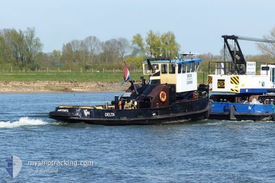
DELTA
Cargo
Current Trip
GRAVE
| Time Travelled | 2 days |
|---|---|
| Remaining Time | --- |
| Distance Travelled | 0.83 nm |
| Remaining Distance | --- |
| AVG Speed | --- |
| MAX Speed | --- |
| AVG Wind | 8.9 knots |
| MAX Wind | 11 knots |
| MIN Temp | 6.3°C / 43.34°F |
| MAX Temp | 12.5°C / 54.5°F |
| Dybgang | 0.2 m |
| Position Modtaget | 2 m siden |
Current Position
| Longitude | --- |
|---|---|
| Latitude | --- |
| Status | Under way using engine |
| Fart | |
| Kurs | --- |
| Område | North Sea |
| Station | T-AIS |
| Position Modtaget | 2 m siden |
Info
Information
The current position of DELTA is in North Sea with coordinates 51.81112° / 5.45636° as reported on 2025-12-12 15:08 by AIS to our vessel tracker app. The vessel's current speed is 0 Knots
The vessel DELTA (MMSI: 244780497) is a Cargo It's sailing under the flag of [NL] Netherlands.
In this page you can find informations about the vessels current position, last detected port calls, and current voyage information. If the vessels is not in coverage by AIS you will find the latest position.
The current position of DELTA is detected by our AIS receivers and we are not responsible for the reliability of the data. The last position was recorded while the vessel was in Coverage by the Ais receivers of our vessel tracking app.
The current draught of DELTA as reported by AIS is 0.2 meters
Weather
| Temperature | 9.1°C / 48.38°F |
|---|---|
| Wind Speed | 6 knots |
| Direction | 189° S |
| Pressure | 1020.7 hPa |
| Humidity | 91.5 % |
| Cloud Coverage | 77 % |
Featured Company
Last Port Calls
| Port | Arrival | Departure | Time In Port |
|---|---|---|---|
| 2025-12-10 06:17 | 2025-12-10 07:26 | 1 h | |
| 2025-12-01 11:35 | 2025-12-09 08:43 | 7 d | |
| 2025-11-19 12:54 | 2025-12-01 08:20 | 11 d | |
| 2025-10-30 19:49 | |||
| 2025-10-09 09:03 | 2025-10-10 06:51 | 21 h | |
| 2025-10-08 09:47 | |||
| 2025-10-03 12:04 | 2025-10-07 11:57 | 3 d |
Most Visited Ports (Last year)
| Port | Arrivals | |
|---|---|---|
| 9 | ||
| 6 | ||
| 3 | ||
| 2 | ||
| 1 | ||
| 1 |
Last Trips
| Origin | Departure | Destination | Arrival | Distance | |
|---|---|---|---|---|---|
| 2025-12-09 09:43 | 2025-12-10 07:17 | 12.02 nm | |||
| 2025-12-01 09:20 | 2025-12-01 12:35 | 14.05 nm | |||
| 2025-10-07 13:57 | 2025-10-09 11:03 | 23.41 nm | |||
| 2025-10-07 13:57 | 2025-10-08 11:47 | 7.92 nm | |||
| 2025-09-11 08:14 | 2025-10-03 14:04 | 75.48 nm |
Events
| Tid | Hændelsen | Detaljer | Position / Dest | Info |
|---|---|---|---|---|
| 2025-12-10 07:31 | STOP Sejllads | 0.75 nm, North West of LITHOIJEN |
51.81100 / 5.45917
GRAVE
|
Fart: 0.3 kn Kurs: 511° |
| 2025-12-10 07:26 | Afsejlet fra sidste havn |
|
51.81115 / 5.46530
GRAVE
|
Fart: 4.1 kn Kurs: 328° |
| 2025-12-10 07:20 | START Sejllads |
51.80591 / 5.46797
[NL] LITHOIJEN
|
Fart: 3.6 kn Kurs: 352° |
|
| 2025-12-10 06:24 | STOP Sejllads |
51.80379 / 5.46796
[NL] LITHOIJEN
|
Fart: 0.1 kn Kurs: 511° |
|
| 2025-12-10 06:17 | Skibe i havn |
|
51.80973 / 5.46649
[NL] LITHOIJEN
|
Fart: 2.7 kn Kurs: 511° |
| 2025-12-10 06:15 | START Sejllads | 0.56 nm, North West of LITHOIJEN |
51.80975 / 5.46443
GRAVE
|
Fart: 3.1 kn Kurs: 77.7° |
| 2025-12-09 12:30 | STOP Sejllads | 0.66 nm, North West of LITHOIJEN |
51.80980 / 5.46052
GRAVE
|
Fart: 0.1 kn Kurs: 511° |
| 2025-12-09 12:26 | START Sejllads | 0.73 nm, North West of LITHOIJEN |
51.80920 / 5.45729
GRAVE
|
Fart: 3.4 kn Kurs: 78.2° |
| 2025-12-09 12:08 | STOP Sejllads | 0.81 nm, North West of LITHOIJEN |
51.80892 / 5.45431
GRAVE
|
Fart: 0.3 kn Kurs: 511° |
| 2025-12-09 12:02 | START Sejllads | 1.07 nm, West of LITHOIJEN |
51.80882 / 5.44653
GRAVE
|
Fart: 3.4 kn Kurs: 89° |