
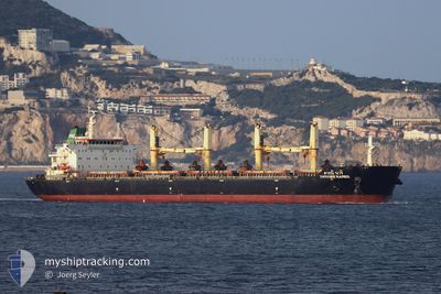
DARANEE NAREE
Bulk Carrier
Current Trip
ID BAH
| Time Travelled | 2 days |
|---|---|
| Remaining Time | --- |
| Distance Travelled | 535.86 nm |
| Remaining Distance | --- |
| AVG Speed | 11.3 Knots |
| MAX Speed | 13.3 Knots |
| AVG Wind | 13.1 knots |
| MAX Wind | 25.8 knots |
| MIN Temp | 8°C / 46.4°F |
| MAX Temp | 16.2°C / 61.16°F |
| Dybgang | 13.5 m |
| Position Modtaget | 23 d siden |
Current Position
| Longitude | --- |
|---|---|
| Latitude | --- |
| Status | Under way sailing |
| Fart | 10 Knots |
| Kurs | 46.5° |
| Område | South China Sea |
| Station | T-AIS |
| Position Modtaget | 23 d siden |
Info
Information
The current position of DARANEE NAREE is in South China Sea with coordinates 1.31601° / 104.37152° as reported on 2025-01-24 23:15 by AIS to our vessel tracker app. The vessel's current speed is 10 Knots
The vessel DARANEE NAREE (IMO: 9613446, MMSI: 566707000) is a Bulk Carrier that was built in 2012 ( 13 år gamle ). It's sailing under the flag of [SG] Singapore.
In this page you can find informations about the vessels current position, last detected port calls, and current voyage information. If the vessels is not in coverage by AIS you will find the latest position.
The current position of DARANEE NAREE is detected by our AIS receivers and we are not responsible for the reliability of the data. The last position was recorded while the vessel was in Coverage by the Ais receivers of our vessel tracking app.
The current draught of DARANEE NAREE as reported by AIS is 13.5 meters
Weather
| Temperature | 7.7°C / 45.86°F |
|---|---|
| Wind Speed | 14 knots |
| Direction | 347° NNW |
| Pressure | 1026.1 hPa |
| Humidity | 57.7 % |
| Cloud Coverage | 14 % |
Featured Company
Last Port Calls
| Port | Arrival | Departure | Time In Port |
|---|---|---|---|
| 2025-02-13 04:05 | 2025-02-15 01:05 | 1 d | |
| 2024-12-24 08:05 | 2025-01-04 03:24 | 10 d | |
| 2024-12-13 15:39 | 2024-12-16 22:50 | 3 d | |
| 2024-12-10 01:07 |
Last Trips
| Origin | Departure | Destination | Arrival | Distance | |
|---|---|---|---|---|---|
| 2025-01-04 05:24 | 2025-02-13 12:05 | 8669.70 nm | |||
| 2024-12-17 01:50 | 2024-12-24 10:05 | 1461.25 nm | |||
| 2024-12-10 04:07 | 2024-12-13 18:39 | 202.40 nm |
Events
| Tid | Hændelsen | Detaljer | Position / Dest | Info |
|---|---|---|---|---|
| 2025-02-15 01:05 | Afsejlet fra sidste havn |
|
26.74611 / 119.72442
ID BAH
|
Fart: 7.5 kn Kurs: 177° |
| 2025-02-15 00:57 | START Sejllads |
26.76265 / 119.72301
[CN] NINGDE
|
Fart: 6.4 kn Kurs: 175° |
|
| 2025-02-13 04:32 | STOP Sejllads |
26.76912 / 119.72297
[CN] NINGDE
|
Fart: Kurs: 342° |
|
| 2025-02-13 04:05 | Skibe i havn |
|
26.76912 / 119.72297
[CN] NINGDE
|
Fart: 4.1 kn Kurs: 351° |
| 2025-02-12 23:49 | START Sejllads | 8.56 nm, North East of LIAN JIANG |
26.41403 / 119.99728
ID BAH
|
Fart: 5 kn Kurs: 204° |
| 2025-02-12 19:23 | STOP Sejllads | 8.85 nm, North East of LIAN JIANG |
26.41793 / 120.00043
ID BAH
|
Fart: 0.3 kn Kurs: 1° |
| 2025-02-12 17:13 | START Sejllads | 14.9 nm, East of LIAN JIANG |
26.35623 / 120.15208
ID BAH
|
Fart: 4.3 kn Kurs: 281° |
| 2025-02-12 13:05 | STOP Sejllads | 20.57 nm, East of LIAN JIANG |
26.39778 / 120.25030
ID BAH
|
Fart: 0.1 kn Kurs: 59° |
| 2025-02-12 05:25 | START Sejllads | 8.4 nm, North East of LIAN JIANG |
26.40716 / 119.99968
ID BAH
|
Fart: 4.2 kn Kurs: 76° |
| 2025-02-12 04:29 | STOP Sejllads | 7.95 nm, North East of LIAN JIANG |
26.40535 / 119.99067
ID BAH
|
Fart: 0.3 kn Kurs: 73° |