
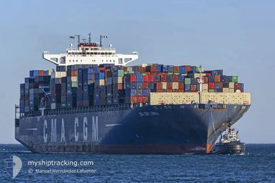
CMA CGM LIBRA
Container Ship
Current Trip
| Time Travelled | 3 days |
|---|---|
| Remaining Time | --- |
| Distance Travelled | 456.58 nm |
| Remaining Distance | 471.62 nm |
| AVG Speed | 12.8 Knots |
| MAX Speed | 14.8 Knots |
| AVG Wind | 9.2 knots |
| MAX Wind | 17.4 knots |
| MIN Temp | 16°C / 60.8°F |
| MAX Temp | 20.3°C / 68.54°F |
| Dybgang | 11.5 m |
| Position Modtaget | 7 d siden |
Current Position
| Longitude | 118.46574° |
|---|---|
| Latitude | 23.71796° |
| Status | Under way using engine |
| Fart | 18.6 Knots |
| Kurs | 55.3° |
| Område | South China Sea |
| Station | T-AIS |
| Position Modtaget | 7 d siden |
Info
Information
The current position of CMA CGM LIBRA is in South China Sea with coordinates 23.71796° / 118.46574° as reported on 2024-05-21 04:07 by AIS to our vessel tracker app. The vessel's current speed is 18.6 Knots and is heading at the port of NINGBO. The estimated time of arrival as calculated by MyShipTracking vessel tracking app is 2024-05-22 14:00 LT
The vessel CMA CGM LIBRA (IMO: 9399193, MMSI: 249819000) is a Container Ship that was built in 2009 ( 15 år gamle ). It's sailing under the flag of [MT] Malta.
In this page you can find informations about the vessels current position, last detected port calls, and current voyage information. If the vessels is not in coverage by AIS you will find the latest position.
The current position of CMA CGM LIBRA is detected by our AIS receivers and we are not responsible for the reliability of the data. The last position was recorded while the vessel was in Coverage by the Ais receivers of our vessel tracking app.
The current draught of CMA CGM LIBRA as reported by AIS is 11.5 meters
Weather
| Temperature | 18.5°C / 65.3°F |
|---|---|
| Wind Speed | 1 knots |
| Direction | 283° WNW |
| Pressure | 1010 hPa |
| Humidity | 66.6 % |
| Cloud Coverage | --- |
Featured Company
Last Port Calls
| Port | Arrival | Departure | Time In Port |
|---|---|---|---|
| 2024-05-24 08:28 | 2024-05-24 23:24 | 14 h | |
| 2024-05-20 05:44 | 2024-05-20 20:18 | 14 h | |
| 2024-04-01 21:18 | 2024-04-04 03:21 | 2 d | |
| 2024-03-28 15:40 | 2024-03-31 04:51 | 2 d | |
| 2024-03-26 13:42 | 2024-03-27 10:44 | 21 h | |
| 2024-03-23 17:49 | 2024-03-25 06:55 | 1 d | |
| 2024-03-22 03:57 | 2024-03-23 06:47 | 1 d | |
| 2024-03-17 22:08 | |||
| 2024-03-16 08:21 |
Most Visited Ports (Last year)
| Port | Arrivals | |
|---|---|---|
| 5 | ||
| 4 | ||
| 4 | ||
| 4 | ||
| 4 | ||
| 4 |
Last Trips
| Origin | Departure | Destination | Arrival | Distance | |
|---|---|---|---|---|---|
| 2024-05-20 20:18 | 2024-05-24 08:28 | 900.23 nm | |||
| 2024-04-04 03:21 | 2024-05-20 05:44 | 13160.92 nm | |||
| 2024-03-31 04:51 | 2024-04-01 21:18 | 447.33 nm | |||
| 2024-03-27 10:44 | 2024-03-28 15:40 | 479.38 nm | |||
| 2024-03-25 06:55 | 2024-03-26 13:42 | 292.48 nm | |||
| 2024-03-23 06:47 | 2024-03-23 17:49 | 47.13 nm | |||
| 2024-03-17 22:08 | 2024-03-22 03:57 | 1612.55 nm | |||
| 2024-02-28 23:46 | 2024-03-16 08:21 | 6521.10 nm |
Events
| Tid | Hændelsen | Detaljer | Position / Dest | Info |
|---|---|---|---|---|
| 2024-05-27 02:57 | STOP Sejllads |
35.76150 / 120.95999
NINGBO
|
Fart: 0.3 kn Kurs: 313° |
|
| 2024-05-27 01:49 | START Sejllads |
35.69756 / 120.91867
NINGBO
|
Fart: 3.8 kn Kurs: 46° |
|
| 2024-05-26 01:52 | STOP Sejllads |
35.69333 / 120.91833
NINGBO
|
Fart: Kurs: -1° |
|
| 2024-05-24 15:24 | START Sejllads | 4.01 nm, West of YANGSHAN |
30.62106 / 122.05867
NINGBO
|
Fart: 3.5 kn Kurs: 145° |
| 2024-05-24 15:24 | Afsejlet fra sidste havn |
|
30.62106 / 122.05867
NINGBO
|
Fart: 1.2 kn Kurs: 143° |
| 2024-05-24 00:28 | Skibe i havn |
|
30.62360 / 122.05904
[CN] YANGSHAN
|
Fart: Kurs: 130° |
| 2024-05-23 23:49 | STOP Sejllads | 4.03 nm, West of YANGSHAN |
30.62358 / 122.05904
NINGBO
|
Fart: Kurs: 131° |
| 2024-05-23 09:41 | START Sejllads | 13.44 nm, South East of NINGBO |
29.78283 / 122.02562
NINGBO
|
Fart: 3.2 kn Kurs: 84° |
| 2024-05-22 08:52 | STOP Sejllads | 13.28 nm, South East of NINGBO |
29.78338 / 122.02178
NINGBO
|
Fart: Kurs: 45° |
| 2024-05-21 04:07 | Udenfor Dækning |
23.71796 / 118.46574
South China Sea
NINGBO
|
Fart: 18.6 kn Kurs: 55.3° |