
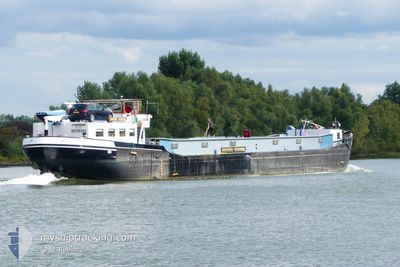
CHAPERON
Cargo
Current Trip
GOTTERWICKERSHAM
| Time Travelled | 4 days |
|---|---|
| Remaining Time | --- |
| Distance Travelled | 155.61 nm |
| Remaining Distance | --- |
| AVG Speed | 7.3 Knots |
| MAX Speed | 7.3 Knots |
| AVG Wind | 9.9 knots |
| MAX Wind | 15.8 knots |
| MIN Temp | 12.3°C / 54.14°F |
| MAX Temp | 27.5°C / 81.5°F |
| Dybgang | 0 m |
| Position Modtaget | 1 m siden |
Current Position
| Longitude | 5.68527° |
|---|---|
| Latitude | 51.89225° |
| Status | Under way using engine |
| Fart | 0.2 Knots |
| Kurs | --- |
| Område | North Sea |
| Station | T-AIS |
| Position Modtaget | 1 m siden |
Info
Information
The current position of CHAPERON is in North Sea with coordinates 51.89225° / 5.68527° as reported on 2024-07-01 12:02 by AIS to our vessel tracker app. The vessel's current speed is 0.2 Knots
The vessel CHAPERON (IMO: 3250303, MMSI: 244620984) is a Cargo It's sailing under the flag of [NL] Netherlands.
In this page you can find informations about the vessels current position, last detected port calls, and current voyage information. If the vessels is not in coverage by AIS you will find the latest position.
The current position of CHAPERON is detected by our AIS receivers and we are not responsible for the reliability of the data. The last position was recorded while the vessel was in Coverage by the Ais receivers of our vessel tracking app.
Weather
| Temperature | 18.2°C / 64.76°F |
|---|---|
| Wind Speed | 11 knots |
| Direction | 307° NW |
| Pressure | 1015 hPa |
| Humidity | 60.9 % |
| Cloud Coverage | 95 % |
Featured Company
Last Port Calls
| Port | Arrival | Departure | Time In Port |
|---|---|---|---|
| 2024-06-27 07:34 | 2024-06-27 07:55 | 21 m | |
| 2024-06-26 09:56 | 2024-06-26 11:10 | 1 h | |
| 2024-06-24 20:39 | 2024-06-25 04:35 | 7 h | |
| 2024-06-24 17:07 | 2024-06-24 17:31 | 23 m | |
| 2024-06-24 15:57 | 2024-06-24 16:02 | 4 m | |
| 2024-06-21 19:04 | 2024-06-24 08:01 | 2 d | |
| 2024-06-20 21:36 | 2024-06-21 05:33 | 7 h | |
| 2024-06-18 21:26 | 2024-06-19 03:11 | 5 h | |
| 2024-06-18 18:10 | 2024-06-18 18:23 | 13 m | |
| 2024-06-18 16:21 |
Most Visited Ports (Last year)
| Port | Arrivals | |
|---|---|---|
| 40 | ||
| 36 | ||
| 36 | ||
| 30 | ||
| 25 | ||
| 13 |
Last Trips
| Origin | Departure | Destination | Arrival | Distance | |
|---|---|---|---|---|---|
| 2024-06-26 13:10 | 2024-06-27 09:34 | 20.25 nm | |||
| 2024-06-25 06:35 | 2024-06-26 11:56 | 103.74 nm | |||
| 2024-06-24 19:31 | 2024-06-24 22:39 | 26.55 nm | |||
| 2024-06-24 18:02 | 2024-06-24 19:07 | 6.79 nm | |||
| 2024-06-24 10:01 | 2024-06-24 17:57 | 19.02 nm | |||
| 2024-06-21 07:33 | 2024-06-21 21:04 | 89.56 nm | |||
| 2024-06-19 05:11 | 2024-06-20 23:36 | 148.73 nm | |||
| 2024-06-18 20:23 | 2024-06-18 23:26 | 22.47 nm | |||
| 2024-06-17 18:11 | 2024-06-18 20:10 | 23.00 nm | |||
| 2024-06-17 18:11 | 2024-06-18 18:21 | 22.27 nm |
Events
| Tid | Hændelsen | Detaljer | Position / Dest | Info |
|---|---|---|---|---|
| 2024-07-01 09:03 | STOP Sejllads | 0.47 nm, East of DEEST |
51.89247 / 5.68483
GOTTERWICKERSHAM
|
Fart: 0.1 kn Kurs: 511° |
| 2024-07-01 07:38 | START Sejllads | 0.84 nm, North East of TIEL |
51.89861 / 5.45571
GOTTERWICKERSHAM
|
Fart: 8 kn Kurs: 158.2° |
| 2024-07-01 07:23 | STOP Sejllads | 0.92 nm, North East of TIEL |
51.90060 / 5.45444
GOTTERWICKERSHAM
|
Fart: 0.2 kn Kurs: 511° |
| 2024-07-01 05:11 | START Sejllads | 0.75 nm, North of NIEUWEGEIN |
52.03864 / 5.11343
GOTTERWICKERSHAM
|
Fart: 6.4 kn Kurs: 152.4° |
| 2024-06-28 17:06 | STOP Sejllads | 0.85 nm, North of NIEUWEGEIN |
52.04062 / 5.11160
GOTTERWICKERSHAM
|
Fart: 0.3 kn Kurs: 511° |
| 2024-06-28 14:20 | START Sejllads | 0.23 nm, West of SCHELLINGWOUDE |
52.38037 / 4.95850
GOTTERWICKERSHAM
|
Fart: 6.6 kn Kurs: 292.4° |
| 2024-06-28 14:10 | STOP Sejllads | 0.15 nm, South West of SCHELLINGWOUDE |
52.37958 / 4.96123
GOTTERWICKERSHAM
|
Fart: 0.1 kn Kurs: 511° |
| 2024-06-28 11:56 | START Sejllads | 0.57 nm, North of LELYSTAD HAVEN |
52.50444 / 5.41723
GOTTERWICKERSHAM
|
Fart: 5.3 kn Kurs: 325.4° |
| 2024-06-28 11:47 | Status er ændret | Under way using engine Default |
52.50276 / 5.41979
GOTTERWICKERSHAM
|
Fart: 2.6 kn Kurs: -1° |
| 2024-06-28 11:47 | STOP Sejllads | 0.47 nm, North of LELYSTAD HAVEN |
52.50276 / 5.41979
GOTTERWICKERSHAM
|
Fart: 0.2 kn Kurs: 511° |