
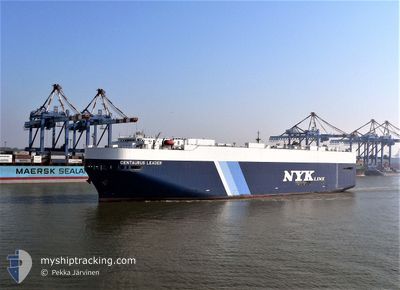
CENTAURUS LEADER
Vehicles Carrier
Current Trip
| Time Travelled | 2 days |
|---|---|
| Remaining Time | --- |
| Distance Travelled | 1041.23 nm |
| Remaining Distance | --- |
| AVG Speed | 17.2 Knots |
| MAX Speed | 19.6 Knots |
| AVG Wind | 13.1 knots |
| MAX Wind | 18.7 knots |
| MIN Temp | 27.5°C / 81.5°F |
| MAX Temp | 29.3°C / 84.74°F |
| Dybgang | 8.7 m |
| Position Modtaget | Nu |
Current Position
| Longitude | -79.50563° |
|---|---|
| Latitude | 25.60750° |
| Status | Under way using engine |
| Fart | 19 Knots |
| Kurs | 0.7° |
| Område | North Atlantic Ocean |
| Station | T-AIS |
| Position Modtaget | Nu |
Info
Information
The current position of CENTAURUS LEADER is in North Atlantic Ocean with coordinates 25.60750° / -79.50563° as reported on 2024-06-30 16:43 by AIS to our vessel tracker app. The vessel's current speed is 19 Knots and is heading at the port of JACKSONVILLE. The estimated time of arrival as calculated by MyShipTracking vessel tracking app is 2024-07-01 03:30 LT
The vessel CENTAURUS LEADER (IMO: 9284740, MMSI: 565503000) is a Vehicles Carrier that was built in 2004 ( 20 år gamle ). It's sailing under the flag of [SG] Singapore.
In this page you can find informations about the vessels current position, last detected port calls, and current voyage information. If the vessels is not in coverage by AIS you will find the latest position.
The current position of CENTAURUS LEADER is detected by our AIS receivers and we are not responsible for the reliability of the data. The last position was recorded while the vessel was in Coverage by the Ais receivers of our vessel tracking app.
The current draught of CENTAURUS LEADER as reported by AIS is 8.7 meters
Weather
| Temperature | 29°C / 84.2°F |
|---|---|
| Wind Speed | 10 knots |
| Direction | 104° ESE |
| Pressure | 1018.9 hPa |
| Humidity | 73.1 % |
| Cloud Coverage | 100 % |
Featured Company
Last Port Calls
| Port | Arrival | Departure | Time In Port |
|---|---|---|---|
| 2024-06-27 01:45 | 2024-06-27 23:39 | 21 h | |
| 2024-06-23 04:59 | 2024-06-23 18:03 | 13 h | |
| 2024-05-31 06:57 | 2024-05-31 15:20 | 8 h | |
| 2024-05-29 11:05 | 2024-05-31 05:54 | 1 d | |
| 2024-05-22 20:11 | 2024-05-23 20:06 | 23 h | |
| 2024-04-14 19:05 | 2024-04-15 22:49 | 1 d | |
| 2024-04-11 18:33 | 2024-04-13 03:24 | 1 d | |
| 2024-04-08 10:27 | 2024-04-09 00:27 | 13 h | |
| 2024-04-04 06:19 | 2024-04-05 01:15 | 18 h |
Last Trips
| Origin | Departure | Destination | Arrival | Distance | |
|---|---|---|---|---|---|
| 2024-06-23 18:03 | 2024-06-27 01:45 | 1311.86 nm | |||
| 2024-05-31 15:20 | 2024-06-23 04:59 | 8577.65 nm | |||
| 2024-05-31 05:54 | 2024-05-31 06:57 | 5.30 nm | |||
| 2024-05-23 20:06 | 2024-05-29 11:05 | 1489.76 nm | |||
| 2024-04-15 22:49 | 2024-05-22 20:11 | 5908.91 nm | |||
| 2024-04-13 03:24 | 2024-04-14 19:05 | 575.58 nm | |||
| 2024-04-09 00:27 | 2024-04-11 18:33 | 658.85 nm | |||
| 2024-04-05 01:15 | 2024-04-08 10:27 | 758.94 nm | |||
| 2024-03-24 18:47 | 2024-04-04 06:19 | 3565.26 nm |
Events
| Tid | Hændelsen | Detaljer | Position / Dest | Info |
|---|---|---|---|---|
| 2024-06-30 16:27 | Status er ændret | Under way using engine Default |
25.52351 / -79.51153
US JAX
|
Fart: 19.1 kn Kurs: 5° |
| 2024-06-30 16:22 | Status er ændret | Default Under way using engine |
25.49371 / -79.51428
US JAX
|
Fart: 19 kn Kurs: 4.6° |
| 2024-06-30 16:14 | Ændre havområde | Bahamas part of the North Atlantic Ocean United States part of the Gulf of Mexico |
25.45113 / -79.51829
North Atlantic Ocean
US JAX
|
Fart: 19.1 kn Kurs: 4.8° |
| 2024-06-30 16:14 | Status er ændret | Under way using engine Default |
25.45113 / -79.51829
US JAX
|
Fart: 19.6 kn Kurs: 5° |
| 2024-06-30 16:07 | Indenfor Dækning |
25.45113 / -79.51829
North Atlantic Ocean
US JAX
|
Fart: 19.1 kn Kurs: 4.8° |
|
| 2024-06-28 05:32 | Status er ændret | Default Under way using engine |
28.82370 / -95.17851
US JAX
|
Fart: 14.4 kn Kurs: 152° |
| 2024-06-28 05:24 | Udenfor Dækning |
28.85105 / -95.19880
Gulf of Mexico
US JAX
|
Fart: 14.4 kn Kurs: 152° |
|
| 2024-06-28 05:15 | Status er ændret | Under way using engine Default |
28.87970 / -95.21692
US JAX
|
Fart: 12.2 kn Kurs: 136° |
| 2024-06-28 05:12 | Status er ændret | Default Under way using engine |
28.88839 / -95.22578
US JAX
|
Fart: 11.2 kn Kurs: 131.2° |
| 2024-06-28 04:39 | Afsejlet fra sidste havn |
|
28.94251 / -95.30765
US JAX
|
Fart: 5.8 kn Kurs: 81° |