
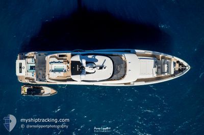
C
Pleasure Craft
Current Trip
US PQM
| Time Travelled | 55 days |
|---|---|
| Remaining Time | --- |
| Distance Travelled | 0.45 nm |
| Remaining Distance | --- |
| AVG Speed | --- |
| MAX Speed | --- |
| AVG Wind | 10.1 knots |
| MAX Wind | 13.5 knots |
| MIN Temp | 19.4°C / 66.92°F |
| MAX Temp | 27.1°C / 80.78°F |
| Dybgang | 2.7 m |
| Position Modtaget | 3 m siden |
Current Position
| Longitude | --- |
|---|---|
| Latitude | --- |
| Status | Moored |
| Fart | |
| Kurs | 183° |
| Område | North Atlantic Ocean |
| Station | T-AIS |
| Position Modtaget | 3 m siden |
Info
Information
The current position of C is in North Atlantic Ocean with coordinates 26.74867° / -80.04894° as reported on 2025-03-07 15:52 by AIS to our vessel tracker app. The vessel's current speed is 0 Knots
The vessel C (IMO: 9838929, MMSI: 538071485) is a Pleasure Craft It's sailing under the flag of [MH] Marshall Is.
In this page you can find informations about the vessels current position, last detected port calls, and current voyage information. If the vessels is not in coverage by AIS you will find the latest position.
The current position of C is detected by our AIS receivers and we are not responsible for the reliability of the data. The last position was recorded while the vessel was in Coverage by the Ais receivers of our vessel tracking app.
The current draught of C as reported by AIS is 2.7 meters
Weather
| Temperature | 20.8°C / 69.44°F |
|---|---|
| Wind Speed | 4 knots |
| Direction | 59° ENE |
| Pressure | 1019.8 hPa |
| Humidity | 44.8 % |
| Cloud Coverage | 23 % |
Featured Company
Last Port Calls
| Port | Arrival | Departure | Time In Port |
|---|---|---|---|
| 2025-01-10 16:29 | 2025-01-10 17:29 | 1 h |
Last Trips
| Origin | Departure | Destination | Arrival | Distance | |
|---|---|---|---|---|---|
| 2024-12-18 07:12 | 2025-01-10 11:29 | 2193.13 nm |
Events
| Tid | Hændelsen | Detaljer | Position / Dest | Info |
|---|---|---|---|---|
| 2025-03-07 05:40 | Indenfor Dækning |
26.74866 / -80.04893
North Atlantic Ocean
|
Fart: Kurs: 193.4° |
|
| 2025-03-07 04:34 | Udenfor Dækning |
26.74866 / -80.04893
North Atlantic Ocean
|
Fart: Kurs: 272.5° |
|
| 2025-03-07 01:22 | Indenfor Dækning |
26.74866 / -80.04894
North Atlantic Ocean
|
Fart: Kurs: 169.5° |
|
| 2025-03-07 00:10 | Udenfor Dækning |
26.74866 / -80.04893
North Atlantic Ocean
|
Fart: Kurs: 209.9° |
|
| 2025-03-06 14:40 | Indenfor Dækning |
26.74867 / -80.04894
North Atlantic Ocean
|
Fart: 0.1 kn Kurs: 122.8° |
|
| 2025-03-05 20:04 | Udenfor Dækning |
26.74867 / -80.04894
North Atlantic Ocean
|
Fart: Kurs: 282.1° |
|
| 2025-03-05 18:40 | Indenfor Dækning |
26.74867 / -80.04894
North Atlantic Ocean
|
Fart: Kurs: 273.1° |
|
| 2025-03-03 19:05 | Udenfor Dækning |
26.75009 / -80.05127
North Atlantic Ocean
|
Fart: 0.1 kn Kurs: 511° |
|
| 2025-03-03 15:16 | Indenfor Dækning |
26.75008 / -80.05118
North Atlantic Ocean
|
Fart: Kurs: 224.2° |
|
| 2025-03-01 19:15 | Udenfor Dækning |
26.75006 / -80.05182
North Atlantic Ocean
|
Fart: Kurs: 66.2° |