
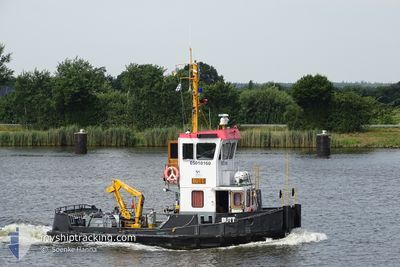
BUTT
Other Type
Current Trip
NOK KONTROLLFAHRT
| Time Travelled | 29 days |
|---|---|
| Remaining Time | --- |
| Distance Travelled | 41.48 nm |
| Remaining Distance | --- |
| AVG Speed | 5.1 Knots |
| MAX Speed | 6.7 Knots |
| AVG Wind | 6.8 knots |
| MAX Wind | 13.5 knots |
| MIN Temp | -3.4°C / 25.88°F |
| MAX Temp | 11.4°C / 52.52°F |
| Dybgang | 2.2 m |
| Position Modtaget | 1 m siden |
Current Position
| Longitude | --- |
|---|---|
| Latitude | --- |
| Status | Default |
| Fart | |
| Kurs | --- |
| Område | North Sea |
| Station | T-AIS |
| Position Modtaget | 1 m siden |
Info
Information
The current position of BUTT is in North Sea with coordinates 54.17349° / 9.44806° as reported on 2026-01-08 03:25 by AIS to our vessel tracker app. The vessel's current speed is 0 Knots
The vessel BUTT (MMSI: 211202570) is a Other Type It's sailing under the flag of [DE] Germany.
In this page you can find informations about the vessels current position, last detected port calls, and current voyage information. If the vessels is not in coverage by AIS you will find the latest position.
The current position of BUTT is detected by our AIS receivers and we are not responsible for the reliability of the data. The last position was recorded while the vessel was in Coverage by the Ais receivers of our vessel tracking app.
The current draught of BUTT as reported by AIS is 2.2 meters
Weather
| Temperature | -2.4°C / 27.68°F |
|---|---|
| Wind Speed | 10 knots |
| Direction | 166° SSE |
| Pressure | 1003.6 hPa |
| Humidity | 95.6 % |
| Cloud Coverage | 100 % |
Featured Company
Last Port Calls
| Port | Arrival | Departure | Time In Port |
|---|---|---|---|
| 2025-12-09 07:36 | 2025-12-09 08:34 | 57 m | |
| 2025-11-17 16:08 | 2025-11-20 07:30 | 2 d | |
| 2025-11-17 10:38 | 2025-11-17 11:39 | 1 h | |
| 2025-11-13 12:56 | 2025-11-17 06:37 | 3 d | |
| 2025-11-11 14:01 | 2025-11-13 12:20 | 1 d | |
| 2025-11-10 10:48 | 2025-11-11 06:34 | 19 h | |
| 2025-11-06 15:08 | 2025-11-10 09:01 | 3 d | |
| 2025-11-04 14:36 | 2025-11-06 06:00 | 1 d | |
| 2025-11-04 06:30 |
Most Visited Ports (Last year)
| Port | Arrivals | |
|---|---|---|
| 41 | ||
| 16 | ||
| 12 | ||
| 4 | ||
| 2 | ||
| 1 |
Last Trips
| Origin | Departure | Destination | Arrival | Distance | |
|---|---|---|---|---|---|
| 2025-11-20 08:30 | 2025-12-09 08:36 | 51.94 nm | |||
| 2025-11-17 12:39 | 2025-11-17 17:08 | 30.25 nm | |||
| 2025-11-17 07:37 | 2025-11-17 11:38 | 30.13 nm | |||
| 2025-11-13 13:20 | 2025-11-13 13:56 | 1.44 nm | |||
| 2025-11-11 07:34 | 2025-11-11 15:01 | 3.08 nm | |||
| 2025-11-10 10:01 | 2025-11-10 11:48 | 0.82 nm | |||
| 2025-11-06 07:00 | 2025-11-06 16:08 | 3.04 nm | |||
| 2025-11-04 07:30 | 2025-11-04 15:36 | 1.98 nm |
Events
| Tid | Hændelsen | Detaljer | Position / Dest | Info |
|---|---|---|---|---|
| 2026-01-06 10:39 | STOP Sejllads | 2.88 nm, North East of FISCHERHUTTE |
54.17353 / 9.44804
NOK KONTROLLFAHRT
|
Fart: 0.3 kn Kurs: 80° |
| 2026-01-06 10:36 | START Sejllads | 2.77 nm, North East of FISCHERHUTTE |
54.17314 / 9.44490
NOK KONTROLLFAHRT
|
Fart: 5.7 kn Kurs: 85.6° |
| 2026-01-06 10:29 | STOP Sejllads | 2.66 nm, North East of FISCHERHUTTE |
54.17301 / 9.44151
NOK KONTROLLFAHRT
|
Fart: 0.1 kn Kurs: 48° |
| 2026-01-06 10:26 | START Sejllads | 2.45 nm, North East of FISCHERHUTTE |
54.17133 / 9.43611
NOK KONTROLLFAHRT
|
Fart: 4.2 kn Kurs: 69° |
| 2026-01-06 10:11 | STOP Sejllads | 2.36 nm, North East of FISCHERHUTTE |
54.16954 / 9.43503
NOK KONTROLLFAHRT
|
Fart: 0.1 kn Kurs: 216° |
| 2026-01-06 10:08 | START Sejllads | 2.56 nm, North East of FISCHERHUTTE |
54.17109 / 9.43984
NOK KONTROLLFAHRT
|
Fart: 4.8 kn Kurs: 241° |
| 2026-01-06 10:05 | STOP Sejllads | 2.67 nm, North East of FISCHERHUTTE |
54.17191 / 9.44261
NOK KONTROLLFAHRT
|
Fart: 0.2 kn Kurs: 174° |
| 2026-01-06 10:04 | START Sejllads | 2.75 nm, North East of FISCHERHUTTE |
54.17271 / 9.44466
NOK KONTROLLFAHRT
|
Fart: 5.5 kn Kurs: 242.2° |
| 2026-01-06 10:01 | STOP Sejllads | 2.89 nm, North East of FISCHERHUTTE |
54.17363 / 9.44821
NOK KONTROLLFAHRT
|
Fart: 0.2 kn Kurs: 145° |
| 2026-01-06 09:25 | START Sejllads | 6.71 nm, North East of FISCHERHUTTE |
54.19806 / 9.54828
NOK KONTROLLFAHRT
|
Fart: 6.4 kn Kurs: 232.9° |