
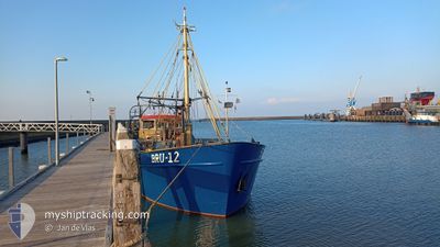
BRU-12 WOLFERT.FRANK
Fishing
Current Trip
| Trip Time | 23 h, 15 mins |
|---|---|
| Trip Distance | 89.29 nm |
| AVG Speed | 6 Knots |
| MAX Speed | 10.5 Knots |
| Dybgang | 1 m |
| AVG Wind | 16.6 knots |
| MAX Wind | 19 knots |
| MIN Temp | 14.6°C / 58.28°F |
| MAX Temp | 15.8°C / 60.44°F |
| Position Modtaget | 1 m siden |
Current Position
| Longitude | 5.41136° |
|---|---|
| Latitude | 53.17055° |
| Status | Under way using engine |
| Fart | 0.1 Knots |
| Kurs | 135° |
| Område | North Sea |
| Station | T-AIS |
| Position Modtaget | 1 m siden |
Info
Information
The current position of BRU-12 WOLFERT.FRANK is in North Sea with coordinates 53.17055° / 5.41136° as reported on 2024-07-05 01:32 by AIS to our vessel tracker app. The vessel's current speed is 0.1 Knots and is currently inside the port of HARLINGEN.
The vessel BRU-12 WOLFERT.FRANK (IMO: 8136013, MMSI: 246431000) is a Fishing It's sailing under the flag of [NL] Netherlands.
In this page you can find informations about the vessels current position, last detected port calls, and current voyage information. If the vessels is not in coverage by AIS you will find the latest position.
The current position of BRU-12 WOLFERT.FRANK is detected by our AIS receivers and we are not responsible for the reliability of the data. The last position was recorded while the vessel was in Coverage by the Ais receivers of our vessel tracking app.
The current draught of BRU-12 WOLFERT.FRANK as reported by AIS is 1 meters
Weather
| Temperature | 15.4°C / 59.72°F |
|---|---|
| Wind Speed | 20 knots |
| Direction | 253° WSW |
| Pressure | 1006.7 hPa |
| Humidity | 70.2 % |
| Cloud Coverage | 61 % |
Featured Company
Most Visited Ports (Last year)
| Port | Arrivals | |
|---|---|---|
| 20 | ||
| 17 | ||
| 13 | ||
| 9 | ||
| 7 | ||
| 5 |
Events
| Tid | Hændelsen | Detaljer | Position / Dest | Info |
|---|---|---|---|---|
| 2024-07-02 17:55 | STOP Sejllads |
53.17056 / 5.41134
[NL] HARLINGEN
|
Fart: Kurs: 137° |
|
| 2024-07-02 17:49 | START Sejllads |
53.17759 / 5.41280
[NL] HARLINGEN
|
Fart: 8 kn Kurs: 221° |
|
| 2024-07-02 17:46 | STOP Sejllads |
53.17941 / 5.41462
[NL] HARLINGEN
|
Fart: Kurs: 176° |
|
| 2024-07-02 17:46 | Skibe i havn |
|
53.17941 / 5.41462
[NL] HARLINGEN
|
Fart: 0.8 kn Kurs: 178° |
| 2024-07-02 17:14 | Indenfor Dækning |
53.12141 / 5.37253
North Sea
|
Fart: 8 kn Kurs: 355.1° |
|
| 2024-07-02 16:07 | Udenfor Dækning |
53.04498 / 5.17141
North Sea
|
Fart: 9.1 kn Kurs: 68.9° |
|
| 2024-07-02 13:34 | START Sejllads | 3.54 nm, North West of DEN OEVER |
52.97706 / 4.96548
FISHING GROUNDS
|
Fart: 3.6 kn Kurs: 325° |
| 2024-07-02 13:30 | STOP Sejllads | 3.47 nm, North West of DEN OEVER |
52.97520 / 4.96532
FISHING GROUNDS
|
Fart: 0.3 kn Kurs: 330° |
| 2024-07-02 12:55 | START Sejllads | 3.58 nm, South East of OUDESCHILD |
52.99579 / 4.91682
FISHING GROUNDS
|
Fart: 3.5 kn Kurs: 3° |
| 2024-07-02 12:45 | STOP Sejllads | 3.85 nm, South East of OUDESCHILD |
52.99676 / 4.92972
FISHING GROUNDS
|
Fart: 0.1 kn Kurs: 334° |