

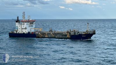
BRISBANE
Trailing Suction Hopper Dredger

Current Trip
| Time Travelled | 17 h, 41 mins |
|---|---|
| Remaining Time | --- |
| Distance Travelled | 107.72 nm |
| Remaining Distance | --- |
| AVG Speed | 7 Knots |
| MAX Speed | 10.5 Knots |
| AVG Wind | 11.8 knots |
| MAX Wind | 14 knots |
| MIN Temp | 23.9°C / 75.02°F |
| MAX Temp | 24.6°C / 76.28°F |
| Dybgang | 5.5 m |
| Position Modtaget | Nu |
Current Position
| Longitude | --- |
|---|---|
| Latitude | --- |
| Status | Under way using engine |
| Fart | 8.9 Knots |
| Kurs | 211.9° |
| Område | Coral Sea |
| Station | T-AIS |
| Position Modtaget | Nu |
Information
The current position of BRISBANE is in Coral Sea with coordinates -27.29259° / 153.22742° as reported on 2025-03-14 02:27 by AIS to our vessel tracker app. The vessel's current speed is 8.9 Knots
The vessel BRISBANE (IMO: 9204623, MMSI: 503380000) is a Trailing Suction Hopper Dredger that was built in 2000 ( 25 år gamle ). It's sailing under the flag of [AU] Australia.
In this page you can find informations about the vessels current position, last detected port calls, and current voyage information. If the vessels is not in coverage by AIS you will find the latest position.
The current position of BRISBANE is detected by our AIS receivers and we are not responsible for the reliability of the data. The last position was recorded while the vessel was in Coverage by the Ais receivers of our vessel tracking app.
The current draught of BRISBANE as reported by AIS is 5.5 meters
Weather
| Temperature | 24.2°C / 75.56°F |
|---|---|
| Wind Speed | 11 knots |
| Direction | 123° ESE |
| Pressure | 1019.6 hPa |
| Humidity | 70.3 % |
| Cloud Coverage | 3 % |


Featured Company
Last Port Calls
| Port | Arrival | Departure | Time In Port |
|---|---|---|---|
| 2025-03-13 05:27 | 2025-03-13 18:47 | 13 h | |
| 2025-03-12 06:17 | 2025-03-12 07:29 | 1 h | |
| 2025-03-11 16:45 | 2025-03-11 17:50 | 1 h | |
| 2025-03-11 13:54 | 2025-03-11 14:57 | 1 h | |
| 2025-03-11 08:27 | 2025-03-11 10:03 | 1 h | |
| 2025-03-11 06:06 | 2025-03-11 07:23 | 1 h | |
| 2025-03-10 15:23 | 2025-03-10 16:42 | 1 h | |
| 2025-03-03 09:52 | 2025-03-10 10:11 | 7 d | |
| 2025-03-02 08:41 | 2025-03-02 15:41 | 7 h | |
| 2025-03-02 06:12 | 2025-03-02 07:47 | 1 h |
Last Trips
| Origin | Departure | Destination | Arrival | Distance | |
|---|---|---|---|---|---|
| 2025-03-12 07:29 | 2025-03-13 05:27 | 6.30 nm | |||
| 2025-03-11 17:50 | 2025-03-12 06:17 | 5.03 nm | |||
| 2025-03-11 14:57 | 2025-03-11 16:45 | 5.59 nm | |||
| 2025-03-11 10:03 | 2025-03-11 13:54 | 5.95 nm | |||
| 2025-03-11 07:23 | 2025-03-11 08:27 | 5.62 nm | |||
| 2025-03-10 16:42 | 2025-03-11 06:06 | 6.68 nm | |||
| 2025-03-10 10:11 | 2025-03-10 15:23 | 4.14 nm | |||
| 2025-03-02 15:41 | 2025-03-03 09:52 | 12.60 nm | |||
| 2025-03-02 07:47 | 2025-03-02 08:41 | 5.39 nm | |||
| 2025-03-02 04:28 | 2025-03-02 06:12 | 6.59 nm |
Events
| Tid | Hændelsen | Detaljer | Position / Dest | Info |
|---|---|---|---|---|
| 2025-03-14 00:09 | Status er ændret | Under way using engine Restricted manoeuverability |
-27.04044 / 153.26424
BRISBANE
|
Fart: 3.1 kn Kurs: 146° |
| 2025-03-14 00:09 | START Sejllads | 5.83 nm, West of BULWER |
-27.04038 / 153.26398
BRISBANE
|
Fart: 3.1 kn Kurs: 133° |
| 2025-03-13 23:48 | STOP Sejllads | 6.02 nm, East of BONGAREE |
-27.03933 / 153.26046
BRISBANE
|
Fart: 0.3 kn Kurs: 186° |
| 2025-03-13 22:38 | START Sejllads | 5.91 nm, West of BULWER |
-27.04013 / 153.26260
BRISBANE
|
Fart: 3.1 kn Kurs: 88° |
| 2025-03-13 22:09 | STOP Sejllads | 5.79 nm, West of BULWER |
-27.04077 / 153.26470
BRISBANE
|
Fart: 0.2 kn Kurs: 120° |
| 2025-03-13 21:18 | Status er ændret | Restricted manoeuverability Under way using engine |
-27.04316 / 153.26943
BRISBANE
|
Fart: 3.6 kn Kurs: 306° |
| 2025-03-13 15:35 | Status er ændret | Under way using engine Restricted manoeuverability |
-26.94781 / 153.20931
BRISBANE
|
Fart: 4.6 kn Kurs: 173° |
| 2025-03-13 15:06 | START Sejllads | 7.76 nm, North East of BANKSIA BEACH |
-26.93805 / 153.20804
BRISBANE
|
Fart: 5.6 kn Kurs: 320.6° |
| 2025-03-13 14:34 | STOP Sejllads | 7.68 nm, North East of BANKSIA BEACH |
-26.94019 / 153.20913
BRISBANE
|
Fart: 0.2 kn Kurs: 159° |
| 2025-03-13 14:00 | START Sejllads | 7.83 nm, South East of CALOUNDRA |
-26.92456 / 153.19646
BRISBANE
|
Fart: 4 kn Kurs: 179° |