

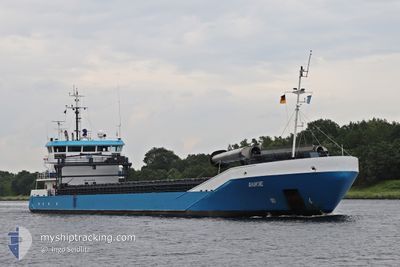
ANKIE
General Cargo

Current Trip
STOCKVIK
| Time Travelled | 2 days |
|---|---|
| Remaining Time | --- |
| Distance Travelled | 252.28 nm |
| Remaining Distance | --- |
| AVG Speed | 8 Knots |
| MAX Speed | 11.7 Knots |
| AVG Wind | 11.2 knots |
| MAX Wind | 21 knots |
| MIN Temp | 1.2°C / 34.16°F |
| MAX Temp | 11.3°C / 52.34°F |
| Dybgang | 5.2 m |
| Position Modtaget | 1 m siden |
Current Position
| Longitude | --- |
|---|---|
| Latitude | --- |
| Status | Under way using engine |
| Fart | 10.8 Knots |
| Kurs | 113.1° |
| Område | Baltic Sea |
| Station | T-AIS |
| Position Modtaget | 1 m siden |
Information
The current position of ANKIE is in Baltic Sea with coordinates 55.26227° / 12.80879° as reported on 2025-03-21 05:41 by AIS to our vessel tracker app. The vessel's current speed is 10.8 Knots
The vessel ANKIE (IMO: 9331359, MMSI: 244554000) is a General Cargo that was built in 2007 ( 18 år gamle ). It's sailing under the flag of [NL] Netherlands.
In this page you can find informations about the vessels current position, last detected port calls, and current voyage information. If the vessels is not in coverage by AIS you will find the latest position.
The current position of ANKIE is detected by our AIS receivers and we are not responsible for the reliability of the data. The last position was recorded while the vessel was in Coverage by the Ais receivers of our vessel tracking app.
The current draught of ANKIE as reported by AIS is 5.2 meters
Weather
| Temperature | 4.4°C / 39.92°F |
|---|---|
| Wind Speed | 11 knots |
| Direction | 83° E |
| Pressure | 1022 hPa |
| Humidity | 77.5 % |
| Cloud Coverage | 55 % |


Featured Company
Last Port Calls
| Port | Arrival | Departure | Time In Port |
|---|---|---|---|
| 2025-03-17 10:08 | 2025-03-18 18:17 | 1 d | |
| 2025-03-15 04:40 | 2025-03-15 05:10 | 29 m | |
| 2025-03-13 14:55 | 2025-03-13 16:34 | 1 h | |
| 2025-03-09 15:25 | 2025-03-12 16:53 | 3 d | |
| 2025-03-04 16:18 | 2025-03-05 16:47 | 1 d | |
| 2025-02-22 20:44 | 2025-02-24 22:54 | 2 d | |
| 2025-02-19 13:26 | 2025-02-22 20:32 | 3 d | |
| 2025-02-18 01:49 | 2025-02-19 12:47 | 1 d | |
| 2025-02-11 09:50 | 2025-02-12 20:37 | 1 d | |
| 2025-02-10 02:25 | 2025-02-10 18:37 | 16 h |
Last Trips
| Origin | Departure | Destination | Arrival | Distance | |
|---|---|---|---|---|---|
| 2025-03-15 05:10 | 2025-03-17 10:08 | 510.00 nm | |||
| 2025-03-13 16:34 | 2025-03-15 04:40 | 6.51 nm | |||
| 2025-03-12 16:53 | 2025-03-13 14:55 | 220.51 nm | |||
| 2025-03-05 16:47 | 2025-03-09 15:25 | 795.14 nm | |||
| 2025-02-24 22:54 | 2025-03-04 16:18 | 1765.25 nm | |||
| 2025-02-22 20:32 | 2025-02-22 20:44 | 1.18 nm | |||
| 2025-02-19 12:47 | 2025-02-19 13:26 | 1.12 nm | |||
| 2025-02-12 20:37 | 2025-02-18 01:49 | 886.32 nm | |||
| 2025-02-10 18:37 | 2025-02-11 09:50 | 114.30 nm | |||
| 2025-02-08 10:46 | 2025-02-10 02:25 | 346.01 nm |
Events
| Tid | Hændelsen | Detaljer | Position / Dest | Info |
|---|---|---|---|---|
| 2025-03-21 05:07 | Ændre havområde | Swedish part of the Baltic Sea Danish part of the Baltic Sea |
55.30302 / 12.64330
Baltic Sea
STOCKVIK
|
Fart: 10.9 kn Kurs: 117° |
| 2025-03-21 05:01 | Ændre havområde | Danish part of the Baltic Sea Danish part of the Kattegat |
55.31807 / 12.62821
Baltic Sea
STOCKVIK
|
Fart: 11.1 kn Kurs: 173.6° |
| 2025-03-21 04:46 | Ændre havområde | Danish part of the Kattegat Swedish part of the Kattegat |
55.36423 / 12.63163
Kattegat
STOCKVIK
|
Fart: 11 kn Kurs: 186.4° |
| 2025-03-21 04:16 | Ændre havområde | Swedish part of the Kattegat Danish part of the Kattegat |
55.45478 / 12.66221
Kattegat
STOCKVIK
|
Fart: 11.1 kn Kurs: 193.5° |
| 2025-03-21 01:19 | Ændre havområde | Danish part of the Kattegat Swedish part of the Kattegat |
55.95284 / 12.65349
Kattegat
STOCKVIK
|
Fart: 10.5 kn Kurs: 204.2° |
| 2025-03-21 00:56 | Ændre havområde | Swedish part of the Kattegat Danish part of the Kattegat |
56.01602 / 12.66059
Kattegat
STOCKVIK
|
Fart: 10.3 kn Kurs: 165.4° |
| 2025-03-20 14:00 | START Sejllads | 13.43 nm, North of RANDERS |
56.68400 / 10.03897
STOCKVIK
|
Fart: 3.2 kn Kurs: 6° |
| 2025-03-20 12:34 | ETA er ændret | 2025/03/23 16:00 2025/03/19 16:00 |
56.68261 / 10.03794
STOCKVIK
|
Fart: Kurs: 36° |
| 2025-03-20 10:09 | Destination er ændret | STOCKVIK MARIAGER |
56.68251 / 10.03779
STOCKVIK
|
Fart: Kurs: 36° |
| 2025-03-20 10:09 | ETA er ændret | 2025/03/19 16:00 2025/03/19 09:00 |
56.68251 / 10.03779
STOCKVIK
|
Fart: Kurs: 36° |