

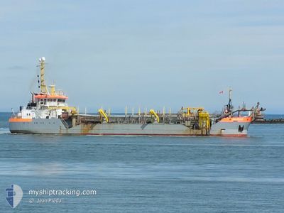
AMAZONE
Trailing Suction Hopper Dredger

Current Trip
| Time Travelled | 6 days |
|---|---|
| Remaining Time | 5 days |
| Distance Travelled | 1548.60 nm |
| Remaining Distance | 1177.62 nm |
| AVG Speed | 9.6 Knots |
| MAX Speed | 10.8 Knots |
| AVG Wind | 11.3 knots |
| MAX Wind | 22.2 knots |
| MIN Temp | 21.4°C / 70.52°F |
| MAX Temp | 26°C / 78.8°F |
| Dybgang | 3.5 m |
| Position Modtaget | 6 d siden |
Current Position
| Longitude | --- |
|---|---|
| Latitude | --- |
| Status | Under way using engine |
| Fart | 9.7 Knots |
| Kurs | 71.3° |
| Område | Caribbean Sea |
| Station | T-AIS |
| Position Modtaget | 6 d siden |
Information
The current position of AMAZONE is in Caribbean Sea with coordinates 18.12257° / -62.68853° as reported on 2025-03-20 05:08 by AIS to our vessel tracker app. The vessel's current speed is 9.7 Knots and is heading at the port of LAS PALMAS. The estimated time of arrival as calculated by MyShipTracking vessel tracking app is 2025-04-01 14:19 LT
The vessel AMAZONE (IMO: 9158630, MMSI: 245718000) is a Trailing Suction Hopper Dredger that was built in 1997 ( 28 år gamle ). It's sailing under the flag of [NL] Netherlands.
In this page you can find informations about the vessels current position, last detected port calls, and current voyage information. If the vessels is not in coverage by AIS you will find the latest position.
The current position of AMAZONE is detected by our AIS receivers and we are not responsible for the reliability of the data. The last position was recorded while the vessel was in Coverage by the Ais receivers of our vessel tracking app.
The current draught of AMAZONE as reported by AIS is 3.5 meters
Weather
| Temperature | 21.4°C / 70.52°F |
|---|---|
| Wind Speed | 23 knots |
| Direction | 60° ENE |
| Pressure | 1026.2 hPa |
| Humidity | 67.5 % |
| Cloud Coverage | 32 % |


Featured Company
Last Port Calls
| Port | Arrival | Departure | Time In Port |
|---|---|---|---|
| 2025-03-19 17:14 | 2025-03-19 22:55 | 5 h | |
| 2025-03-13 09:35 | 2025-03-13 11:23 | 1 h | |
| 2025-03-13 07:03 | 2025-03-13 08:23 | 1 h | |
| 2025-03-13 04:47 | 2025-03-13 05:47 | 1 h | |
| 2025-03-12 18:39 | 2025-03-12 19:27 | 48 m | |
| 2025-03-12 16:11 | 2025-03-12 17:23 | 1 h | |
| 2025-03-12 13:51 | 2025-03-12 15:07 | 1 h | |
| 2025-03-12 12:19 | 2025-03-12 12:51 | 32 m | |
| 2025-03-12 09:11 | 2025-03-12 10:23 | 1 h | |
| 2025-03-12 06:55 | 2025-03-12 08:04 | 1 h |
Most Visited Ports (Last year)
| Port | Arrivals | |
|---|---|---|
| 313 | ||
| 244 | ||
| 159 | ||
| 151 | ||
| 107 | ||
| 103 |
Last Trips
| Origin | Departure | Destination | Arrival | Distance | |
|---|---|---|---|---|---|
| 2025-03-13 11:23 | 2025-03-19 17:14 | 1494.48 nm | |||
| 2025-03-13 08:23 | 2025-03-13 09:35 | 5.21 nm | |||
| 2025-03-13 05:47 | 2025-03-13 07:03 | 7.68 nm | |||
| 2025-03-12 19:27 | 2025-03-13 04:47 | 44.94 nm | |||
| 2025-03-12 17:23 | 2025-03-12 18:39 | 8.43 nm | |||
| 2025-03-12 15:07 | 2025-03-12 16:11 | 8.23 nm | |||
| 2025-03-12 12:51 | 2025-03-12 13:51 | 7.82 nm | |||
| 2025-03-12 10:23 | 2025-03-12 12:19 | 8.91 nm | |||
| 2025-03-12 08:04 | 2025-03-12 09:11 | 8.00 nm | |||
| 2025-03-12 05:43 | 2025-03-12 06:55 | 8.05 nm |
Events
| Tid | Hændelsen | Detaljer | Position / Dest | Info |
|---|---|---|---|---|
| 2025-03-20 05:18 | Status er ændret | Default Under way using engine |
18.13177 / -62.66089
ES LPA
|
Fart: 9.7 kn Kurs: 71.3° |
| 2025-03-20 05:08 | Udenfor Dækning |
18.12257 / -62.68853
Caribbean Sea
ES LPA
|
Fart: 9.7 kn Kurs: 71.3° |
|
| 2025-03-20 03:31 | Ændre havområde | Saint-Martin part of the Caribbean Sea Sint-Maarten part of the Caribbean Sea |
18.02135 / -62.94750
Caribbean Sea
ES LPA
|
Fart: 10 kn Kurs: 68.6° |
| 2025-03-20 02:55 | Afsejlet fra sidste havn |
|
18.00455 / -63.04666
ES LPA
|
Fart: 8.2 kn Kurs: 165° |
| 2025-03-20 02:54 | Destination er ændret | ES LPA SX PHI |
18.00683 / -63.04675
[SX] PHILIPSBURG
|
Fart: 7.2 kn Kurs: 181° |
| 2025-03-20 02:54 | ETA er ændret | 2025/04/02 12:00 2025/03/20 12:00 |
18.00683 / -63.04675
[SX] PHILIPSBURG
|
Fart: 7.2 kn Kurs: 181° |
| 2025-03-20 02:53 | START Sejllads |
18.00747 / -63.04662
[SX] PHILIPSBURG
|
Fart: 6.3 kn Kurs: 187° |
|
| 2025-03-20 02:46 | Status er ændret | Under way using engine Moored |
18.00936 / -63.04466
[SX] PHILIPSBURG
|
Fart: 0.4 kn Kurs: 5° |
| 2025-03-20 02:43 | Status er ændret | Moored Under way using engine |
18.00929 / -63.04448
[SX] PHILIPSBURG
|
Fart: Kurs: 4° |
| 2025-03-20 02:42 | Status er ændret | Under way using engine Moored |
18.00931 / -63.04447
[SX] PHILIPSBURG
|
Fart: Kurs: 4° |