
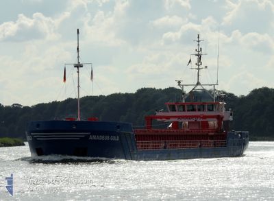
AMADEUS GOLD
General Cargo
Current Trip
| Time Travelled | 2 days |
|---|---|
| Remaining Time | --- |
| Distance Travelled | 557.33 nm |
| Remaining Distance | --- |
| AVG Speed | 8 Knots |
| MAX Speed | 11 Knots |
| AVG Wind | 8.6 knots |
| MAX Wind | 19 knots |
| MIN Temp | 3.2°C / 37.76°F |
| MAX Temp | 10°C / 50°F |
| Dybgang | 3.5 m |
| Position Modtaget | Nu |
Current Position
| Longitude | 9.43063° |
|---|---|
| Latitude | 54.16895° |
| Status | Under way using engine |
| Fart | 5 Knots |
| Kurs | 243.3° |
| Område | Baltic Sea |
| Station | T-AIS |
| Position Modtaget | Nu |
Info
Information
The current position of AMADEUS GOLD is in Baltic Sea with coordinates 54.16895° / 9.43063° as reported on 2024-04-28 05:05 by AIS to our vessel tracker app. The vessel's current speed is 5 Knots and is heading at the port of GENK. The estimated time of arrival as calculated by MyShipTracking vessel tracking app is 2024-04-30 17:00 LT
The vessel AMADEUS GOLD (IMO: 9479565, MMSI: 244810730) is a General Cargo that was built in 2010 ( 14 år gamle ). It's sailing under the flag of [NL] Netherlands.
In this page you can find informations about the vessels current position, last detected port calls, and current voyage information. If the vessels is not in coverage by AIS you will find the latest position.
The current position of AMADEUS GOLD is detected by our AIS receivers and we are not responsible for the reliability of the data. The last position was recorded while the vessel was in Coverage by the Ais receivers of our vessel tracking app.
The current draught of AMADEUS GOLD as reported by AIS is 3.5 meters
Weather
| Temperature | 9°C / 48.2°F |
|---|---|
| Wind Speed | 8 knots |
| Direction | 114° ESE |
| Pressure | 1007.7 hPa |
| Humidity | 89 % |
| Cloud Coverage | 99 % |
Featured Company
Last Port Calls
| Port | Arrival | Departure | Time In Port |
|---|---|---|---|
| 2024-04-25 06:48 | 2024-04-25 15:32 | 8 h | |
| 2024-04-22 13:13 | 2024-04-23 09:02 | 19 h | |
| 2024-04-20 17:55 | 2024-04-20 17:58 | 3 m | |
| 2024-04-18 02:58 | 2024-04-18 20:18 | 17 h | |
| 2024-04-16 19:44 | 2024-04-16 20:42 | 57 m | |
| 2024-04-12 18:01 | 2024-04-13 16:18 | 22 h | |
| 2024-04-09 10:42 | 2024-04-12 12:30 | 3 d | |
| 2024-04-03 20:20 | 2024-04-05 12:09 | 1 d | |
| 2024-04-02 19:29 | 2024-04-02 20:04 | 34 m | |
| 2024-03-27 16:18 | 2024-03-28 10:07 | 17 h |
Most Visited Ports (Last year)
| Port | Arrivals | |
|---|---|---|
| 27 | ||
| 4 | ||
| 4 | ||
| 4 | ||
| 4 | ||
| 4 |
Last Trips
| Origin | Departure | Destination | Arrival | Distance | |
|---|---|---|---|---|---|
| 2024-04-23 11:02 | 2024-04-25 09:48 | 462.62 nm | |||
| 2024-04-20 19:58 | 2024-04-22 15:13 | 82.44 nm | |||
| 2024-04-18 22:18 | 2024-04-20 19:55 | 319.87 nm | |||
| 2024-04-16 22:42 | 2024-04-18 04:58 | 183.93 nm | |||
| 2024-04-13 18:18 | 2024-04-16 21:44 | 585.30 nm | |||
| 2024-04-12 14:30 | 2024-04-12 20:01 | 44.00 nm | |||
| 2024-04-05 14:09 | 2024-04-09 12:42 | 885.81 nm | |||
| 2024-04-02 22:04 | 2024-04-03 22:20 | 195.20 nm | |||
| 2024-03-28 11:07 | 2024-04-02 21:29 | 763.78 nm | |||
| 2024-03-21 23:18 | 2024-03-27 17:18 | 777.33 nm |
Events
| Tid | Hændelsen | Detaljer | Position / Dest | Info |
|---|---|---|---|---|
| 2024-04-28 01:07 | START Sejllads | 7.14 nm, West of KIEL |
54.34227 / 9.95699
GENK
|
Fart: 3.1 kn Kurs: 254° |
| 2024-04-28 01:06 | Status er ændret | Under way using engine Moored |
54.34243 / 9.95846
GENK
|
Fart: 0.3 kn Kurs: 265° |
| 2024-04-28 00:53 | Status er ændret | Moored Under way using engine |
54.34258 / 9.96049
GENK
|
Fart: 0.3 kn Kurs: 260° |
| 2024-04-28 00:33 | STOP Sejllads | 6.97 nm, West of KIEL |
54.34260 / 9.96203
GENK
|
Fart: 0.3 kn Kurs: 264° |
| 2024-04-27 23:19 | START Sejllads | 1.4 nm, South West of STICKENHΟRN SPORT |
54.36654 / 10.13930
GENK
|
Fart: 4.6 kn Kurs: 283° |
| 2024-04-27 23:17 | Status er ændret | Under way using engine Moored |
54.36608 / 10.14220
GENK
|
Fart: Kurs: 281° |
| 2024-04-27 23:13 | Status er ændret | Moored Under way using engine |
54.36594 / 10.14254
GENK
|
Fart: Kurs: 282° |
| 2024-04-27 22:57 | STOP Sejllads | 1.35 nm, South West of STICKENHΟRN SPORT |
54.36594 / 10.14255
GENK
|
Fart: 0.2 kn Kurs: 283° |
| 2024-04-27 20:38 | Ændre havområde | German part of the Baltic Sea Danish part of the Baltic Sea |
54.56278 / 10.55944
Baltic Sea
GENK
|
Fart: 9.5 kn Kurs: 248.6° |
| 2024-04-27 19:47 | Ændre havområde | Danish part of the Baltic Sea German part of the Baltic Sea |
54.58173 / 10.79150
Baltic Sea
GENK
|
Fart: 9.8 kn Kurs: 264.1° |